
GRANDE TEMA
Cargo
Current Trip
| Time Travelled | 16 h, 17 mins |
|---|---|
| Remaining Time | 2 days |
| Distance Travelled | 254.20 nm |
| Remaining Distance | 1007.02 nm |
| AVG Speed | 15.9 Knots |
| MAX Speed | 16.6 Knots |
| AVG Wind | 7.2 knots |
| MAX Wind | 11 knots |
| MIN Temp | 23.2°C / 73.76°F |
| MAX Temp | 25.4°C / 77.72°F |
| Draught | 8.3 m |
| Position Received | 2 h, 2 m ago |
Current Position
| Longitude | -42.78277° |
|---|---|
| Latitude | -23.41264° |
| Status | Under way using engine |
| Speed | 16.4 Knots |
| Course | 72.4° |
| Area | South Atlantic Ocean |
| Station | T-AIS |
| Position Received | 2 h, 2 m ago |
Info
Information
The current position of GRANDE TEMA is in South Atlantic Ocean with coordinates -23.41264° / -42.78277° as reported on 2024-04-25 11:28 by AIS to our vessel tracker app. The vessel's current speed is 16.4 Knots and is heading at the port of SUAPE. The estimated time of arrival as calculated by MyShipTracking vessel tracking app is 2024-04-28 04:02 LT
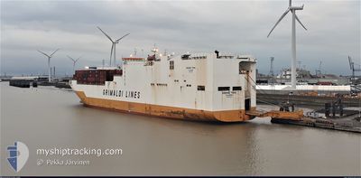
The vessel GRANDE TEMA (IMO: 9672090, MMSI: 247341300) is a Cargo It's sailing under the flag of [IT] Italy.
In this page you can find informations about the vessels current position, last detected port calls, and current voyage information. If the vessels is not in coverage by AIS you will find the latest position.
The current position of GRANDE TEMA is detected by our AIS receivers and we are not responsible for the reliability of the data. The last position was recorded while the vessel was in Coverage by the Ais receivers of our vessel tracking app.
The current draught of GRANDE TEMA as reported by AIS is 8.3 meters
Weather
| Temperature | 25.4°C / 77.72°F |
|---|---|
| Wind Speed | 8 knots |
| Direction | 251° WSW |
| Pressure | 1017.7 hPa |
| Humidity | 83.8 % |
| Cloud Coverage | 17 % |
Featured Company
Last Port Calls
| Port | Arrival | Departure | Time In Port |
|---|---|---|---|
| 2024-04-23 15:00 | 2024-04-24 21:14 | 1 d | |
| 2024-04-22 06:32 | 2024-04-23 02:44 | 20 h | |
| 2024-04-10 15:58 | 2024-04-11 10:33 | 18 h | |
| 2024-04-07 07:11 | 2024-04-09 07:33 | 2 d | |
| 2024-04-06 06:37 | 2024-04-07 00:41 | 18 h | |
| 2024-03-31 09:11 | 2024-04-01 18:31 | 1 d | |
| 2024-03-18 09:18 | 2024-03-19 00:28 | 15 h | |
| 2024-03-15 19:00 | 2024-03-17 03:25 | 1 d | |
| 2024-03-15 04:15 | 2024-03-15 18:40 | 14 h | |
| 2024-03-06 18:06 | 2024-03-08 01:13 | 1 d |
Last Trips
| Origin | Departure | Destination | Arrival | Distance | |
|---|---|---|---|---|---|
| 2024-04-22 23:44 | 2024-04-23 12:00 | 177.38 nm | |||
| 2024-04-11 10:33 | 2024-04-22 03:32 | 3431.62 nm | |||
| 2024-04-09 08:33 | 2024-04-10 15:58 | 283.75 nm | |||
| 2024-04-07 01:41 | 2024-04-07 08:11 | 84.95 nm | |||
| 2024-04-01 18:31 | 2024-04-06 07:37 | 1622.85 nm | |||
| 2024-03-18 20:28 | 2024-03-31 09:11 | 3673.95 nm | |||
| 2024-03-16 23:25 | 2024-03-18 05:18 | 408.37 nm | |||
| 2024-03-15 14:40 | 2024-03-15 15:00 | 0.76 nm | |||
| 2024-03-07 19:13 | 2024-03-15 00:15 | 2039.10 nm | |||
| 2024-03-03 13:47 | 2024-03-06 12:06 | 441.97 nm |
Events
| Time | Event | Details | Position / Dest | Info |
|---|---|---|---|---|
| 2024-04-25 11:32 | Status Changed | Default Under way using engine |
-23.40500 / -42.75834
BR SSZ>BR SUA
|
Speed: 16.4 kn Course: 72.4° |
| 2024-04-25 11:28 | OUT of Coverage |
-23.41264 / -42.78277
South Atlantic Ocean
BR SSZ>BR SUA
|
Speed: 16.4 kn Course: 72.4° |
|
| 2024-04-25 11:27 | Status Changed | Under way using engine Default |
-23.41293 / -42.78372
BR SSZ>BR SUA
|
Speed: 16.4 kn Course: 72° |
| 2024-04-25 11:20 | IN Coverage |
-23.41264 / -42.78277
South Atlantic Ocean
BR SSZ>BR SUA
|
Speed: 16.4 kn Course: 72.4° |
|
| 2024-04-25 10:32 | Status Changed | Default Under way using engine |
-23.48667 / -43.04167
BR SSZ>BR SUA
|
Speed: 15.8 kn Course: 71.2° |
| 2024-04-25 10:26 | OUT of Coverage |
-23.49636 / -43.07137
South Atlantic Ocean
BR SSZ>BR SUA
|
Speed: 15.8 kn Course: 71.2° |
|
| 2024-04-25 10:20 | Status Changed | Under way using engine Default |
-23.50477 / -43.09908
BR SSZ>BR SUA
|
Speed: 15.8 kn Course: 73° |
| 2024-04-25 10:15 | Status Changed | Default Under way using engine |
-23.51095 / -43.12100
BR SSZ>BR SUA
|
Speed: 15.9 kn Course: 73.6° |
| 2024-04-25 09:23 | Status Changed | Under way using engine Default |
-23.58283 / -43.35941
BR SSZ>BR SUA
|
Speed: 15.7 kn Course: 73° |
| 2024-04-25 09:16 | Status Changed | Default Under way using engine |
-23.59183 / -43.38976
BR SSZ>BR SUA
|
Speed: 15.6 kn Course: 72.3° |