
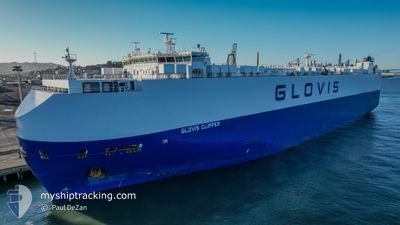
GLOVIS CLIPPER
Vehicles Carrier
Current Trip
| Time Travelled | 1 day |
|---|---|
| Remaining Time | --- |
| Distance Travelled | 427.33 nm |
| Remaining Distance | --- |
| AVG Speed | 13 Knots |
| MAX Speed | 16.4 Knots |
| AVG Wind | 7.2 knots |
| MAX Wind | 23.5 knots |
| MIN Temp | 5.7°C / 42.26°F |
| MAX Temp | 21°C / 69.8°F |
| Draught | 8.4 m |
| Position Received | 20 h, 40 m ago |
Current Position
| Longitude | -125.03902° |
|---|---|
| Latitude | 46.01352° |
| Status | Under way using engine |
| Speed | 15.1 Knots |
| Course | 237.6° |
| Area | North Pacific Ocean |
| Station | T-AIS |
| Position Received | 20 h, 40 m ago |
Info
Information
The current position of GLOVIS CLIPPER is in North Pacific Ocean with coordinates 46.01352° / -125.03902° as reported on 2024-04-24 10:21 by AIS to our vessel tracker app. The vessel's current speed is 15.1 Knots and is heading at the port of PYEONGTAEK. The estimated time of arrival as calculated by MyShipTracking vessel tracking app is 2024-05-09 06:00 LT
The vessel GLOVIS CLIPPER (IMO: 9441582, MMSI: 311054400) is a Vehicles Carrier that was built in 2012 ( 12 years old ). It's sailing under the flag of [BS] Bahamas.
In this page you can find informations about the vessels current position, last detected port calls, and current voyage information. If the vessels is not in coverage by AIS you will find the latest position.
The current position of GLOVIS CLIPPER is detected by our AIS receivers and we are not responsible for the reliability of the data. The last position was recorded while the vessel was in Coverage by the Ais receivers of our vessel tracking app.
The current draught of GLOVIS CLIPPER as reported by AIS is 8.4 meters
Weather
| Temperature | 10.1°C / 50.18°F |
|---|---|
| Wind Speed | 22 knots |
| Direction | 222° SW |
| Pressure | 1010.2 hPa |
| Humidity | 96.8 % |
| Cloud Coverage | 100 % |
Featured Company
Last Port Calls
| Port | Arrival | Departure | Time In Port |
|---|---|---|---|
| 2024-04-23 07:09 | 2024-04-24 00:02 | 16 h | |
| 2024-04-20 06:58 | 2024-04-21 04:26 | 21 h | |
| 2024-04-18 12:27 | 2024-04-18 22:23 | 9 h | |
| 2024-04-12 13:56 | 2024-04-14 16:56 | 2 d | |
| 2024-04-10 01:00 | 2024-04-10 11:46 | 10 h | |
| 2024-04-09 02:02 | 2024-04-09 07:39 | 5 h | |
| 2024-04-08 21:22 | |||
| 2024-04-08 03:13 | 2024-04-08 08:06 | 4 h | |
| 2024-03-31 02:46 | 2024-03-31 12:26 | 9 h | |
| 2024-03-26 08:09 | 2024-03-26 18:59 | 10 h |
Most Visited Ports (Last year)
| Port | Arrivals | |
|---|---|---|
| 6 | ||
| 5 | ||
| 4 | ||
| 3 | ||
| 3 | ||
| 3 |
Last Trips
| Origin | Departure | Destination | Arrival | Distance | |
|---|---|---|---|---|---|
| 2024-04-20 21:26 | 2024-04-23 00:09 | 681.46 nm | |||
| 2024-04-18 15:23 | 2024-04-19 23:58 | 514.89 nm | |||
| 2024-04-14 11:56 | 2024-04-18 05:27 | 1312.26 nm | |||
| 2024-04-10 05:46 | 2024-04-12 08:56 | 727.68 nm | |||
| 2024-04-09 01:39 | 2024-04-09 19:00 | 219.59 nm | |||
| 2024-04-08 02:06 | 2024-04-08 20:02 | 92.60 nm | |||
| 2024-04-08 02:06 | 2024-04-08 15:22 | 92.44 nm | |||
| 2024-03-31 07:26 | 2024-04-07 21:13 | 1720.83 nm | |||
| 2024-03-26 15:59 | 2024-03-30 21:46 | 1352.37 nm | |||
| 2024-03-14 21:00 | 2024-03-26 05:09 | 3502.74 nm |
Events
| Time | Event | Details | Position / Dest | Info |
|---|---|---|---|---|
| 2024-04-24 10:25 | Status Changed | Default Under way using engine |
46.00426 / -125.05976
KRPTK
|
Speed: 15.1 kn Course: 237.6° |
| 2024-04-24 10:21 | Status Changed | Under way using engine Default |
46.01352 / -125.03902
KRPTK
|
Speed: 15.1 kn Course: 237° |
| 2024-04-24 10:21 | OUT of Coverage |
46.01352 / -125.03902
North Pacific Ocean
KRPTK
|
Speed: 15.1 kn Course: 237.6° |
|
| 2024-04-24 10:13 | Status Changed | Default Under way using engine |
46.03173 / -124.99774
KRPTK
|
Speed: 14.9 kn Course: 238° |
| 2024-04-24 03:26 | ETA Changed | 2024/05/09 06:00 2024/05/09 04:00 |
46.16784 / -123.08760
KRPTK
|
Speed: 13 kn Course: 306.9° |
| 2024-04-24 01:27 | Status Changed | Under way using engine Default |
45.88785 / -122.80120
KRPTK
|
Speed: 10.4 kn Course: 331° |
| 2024-04-24 01:10 | IN Coverage |
45.89262 / -122.80382
North Pacific Ocean
KRPTK
|
Speed: 9.9 kn Course: 340.1° |
|
| 2024-04-24 00:40 | Draught Changed | 8.4 8.3 |
45.73300 / -122.76093
KRPTK
|
Speed: 13.4 kn Course: 11° |
| 2024-04-24 00:10 | START Moving | 2.48 nm, North West of VANCOUVER |
45.65480 / -122.76067
KRPTK
|
Speed: 8.2 kn Course: 321° |
| 2024-04-24 00:02 | PORT DEPARTURE |
|
45.64755 / -122.75391
KRPTK
|
Speed: Course: 137° |