
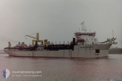
GERARDUS MERCATOR
Trailing Suction Hopper Dredger
Current Trip
NMDC
| Time Travelled | --- |
|---|---|
| Remaining Time | --- |
| Distance Travelled | 6246.34 nm |
| Remaining Distance | --- |
| AVG Speed | 10.4 Knots |
| MAX Speed | 10.4 Knots |
| AVG Wind | 7.5 knots |
| MAX Wind | 20.5 knots |
| MIN Temp | 30°C / 86°F |
| MAX Temp | 35.7°C / 96.26°F |
| Draught | 12.5 m |
| Position Received | Now |
Current Position
| Longitude | 54.33258° |
|---|---|
| Latitude | 24.78280° |
| Status | Restricted manoeuverability |
| Speed | 1.6 Knots |
| Course | 64° |
| Area | Persian Gulf |
| Station | T-AIS |
| Position Received | Now |
Info
Information
The current position of GERARDUS MERCATOR is in Persian Gulf with coordinates 24.78280° / 54.33258° as reported on 2024-04-25 14:44 by AIS to our vessel tracker app. The vessel's current speed is 1.6 Knots
The vessel GERARDUS MERCATOR (IMO: 9119335, MMSI: 645309000) is a Trailing Suction Hopper Dredger that was built in 1997 ( 27 years old ). It's sailing under the flag of [MU] Mauritius.
In this page you can find informations about the vessels current position, last detected port calls, and current voyage information. If the vessels is not in coverage by AIS you will find the latest position.
The current position of GERARDUS MERCATOR is detected by our AIS receivers and we are not responsible for the reliability of the data. The last position was recorded while the vessel was in Coverage by the Ais receivers of our vessel tracking app.
The current draught of GERARDUS MERCATOR as reported by AIS is 12.5 meters
Weather
| Temperature | 26°C / 78.8°F |
|---|---|
| Wind Speed | 7 knots |
| Direction | 31° NNE |
| Pressure | 1005.6 hPa |
| Humidity | 70.1 % |
| Cloud Coverage | --- |
Featured Company
Last Port Calls
Last Trips
| Origin | Departure | Destination | Arrival | Distance |
|---|
Events
| Time | Event | Details | Position / Dest | Info |
|---|---|---|---|---|
| 2024-04-25 12:59 | STOP Moving | 17.6 nm, West of KHALIFA |
24.79106 / 54.34598
NMDC
|
Speed: 0.3 kn Course: 41° |
| 2024-04-25 12:01 | START Moving | 7.15 nm, South West of KHALIFA |
24.74676 / 54.55526
NMDC
|
Speed: 3.3 kn Course: 243° |
| 2024-04-25 08:03 | STOP Moving | 7.04 nm, South West of KHALIFA |
24.74694 / 54.55744
NMDC
|
Speed: 0.3 kn Course: 149° |
| 2024-04-25 05:39 | START Moving | 17.41 nm, North of ABU DHABI |
24.78697 / 54.34698
NMDC
|
Speed: 3.1 kn Course: 42° |
| 2024-04-25 04:29 | STOP Moving | 17.15 nm, West of KHALIFA |
24.79843 / 54.35377
NMDC
|
Speed: 0.3 kn Course: 211° |
| 2024-04-25 03:27 | START Moving | 7.4 nm, South West of KHALIFA |
24.74628 / 54.55019
NMDC
|
Speed: 3.1 kn Course: 331° |
| 2024-04-24 23:50 | STOP Moving | 7.3 nm, South West of KHALIFA |
24.74244 / 54.55488
NMDC
|
Speed: 0.3 kn Course: 141° |
| 2024-04-24 22:21 | START Moving | 16.71 nm, North of ABU DHABI |
24.77569 / 54.33819
NMDC
|
Speed: 3.1 kn Course: 73° |
| 2024-04-24 19:49 | STOP Moving | 17.53 nm, West of KHALIFA |
24.79344 / 54.34702
NMDC
|
Speed: 0.3 kn Course: 253° |
| 2024-04-24 18:40 | START Moving | 7.28 nm, South West of KHALIFA |
24.74510 / 54.55359
NMDC
|
Speed: 3.1 kn Course: 355° |