
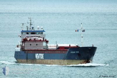
FRISIAN SEA
General Cargo
Current Trip
| Time Travelled | 2 days |
|---|---|
| Remaining Time | 2 days |
| Distance Travelled | 456.51 nm |
| Remaining Distance | 286.76 nm |
| AVG Speed | 8 Knots |
| MAX Speed | 11.9 Knots |
| AVG Wind | 9.9 knots |
| MAX Wind | 19 knots |
| MIN Temp | 1.4°C / 34.52°F |
| MAX Temp | 7.6°C / 45.68°F |
| Draught | 6 m |
| Position Received | Now |
Current Position
| Longitude | 9.14680° |
|---|---|
| Latitude | 53.89418° |
| Status | Under way using engine |
| Speed | |
| Course | 227° |
| Area | Baltic Sea |
| Station | T-AIS |
| Position Received | Now |
Info
Information
The current position of FRISIAN SEA is in Baltic Sea with coordinates 53.89418° / 9.14680° as reported on 2024-04-24 23:56 by AIS to our vessel tracker app. The vessel's current speed is 0 Knots and is heading at the port of SCHIEDAM. The estimated time of arrival as calculated by MyShipTracking vessel tracking app is 2024-04-27 00:14 LT
The vessel FRISIAN SEA (IMO: 9534547, MMSI: 244780424) is a General Cargo that was built in 2014 ( 10 years old ). It's sailing under the flag of [NL] Netherlands.
In this page you can find informations about the vessels current position, last detected port calls, and current voyage information. If the vessels is not in coverage by AIS you will find the latest position.
The current position of FRISIAN SEA is detected by our AIS receivers and we are not responsible for the reliability of the data. The last position was recorded while the vessel was in Coverage by the Ais receivers of our vessel tracking app.
The current draught of FRISIAN SEA as reported by AIS is 6 meters
Weather
| Temperature | 1.5°C / 34.7°F |
|---|---|
| Wind Speed | 3 knots |
| Direction | 61° ENE |
| Pressure | 1004.2 hPa |
| Humidity | 95 % |
| Cloud Coverage | 50 % |
Featured Company
Last Port Calls
| Port | Arrival | Departure | Time In Port |
|---|---|---|---|
| 2024-04-21 07:19 | 2024-04-22 22:37 | 1 d | |
| 2024-04-18 10:42 | 2024-04-19 20:33 | 1 d | |
| 2024-04-14 08:39 | 2024-04-16 10:16 | 2 d | |
| 2024-04-12 08:12 | 2024-04-14 08:12 | 2 d | |
| 2024-04-06 04:09 | 2024-04-10 21:18 | 4 d | |
| 2024-04-04 03:03 | 2024-04-04 23:21 | 20 h | |
| 2024-03-31 04:52 | 2024-04-04 02:16 | 3 d | |
| 2024-03-28 15:41 | 2024-03-31 04:17 | 2 d | |
| 2024-03-24 06:17 | 2024-03-25 10:51 | 1 d | |
| 2024-03-19 12:08 | 2024-03-20 16:20 | 1 d |
Last Trips
| Origin | Departure | Destination | Arrival | Distance | |
|---|---|---|---|---|---|
| 2024-04-19 22:33 | 2024-04-21 10:19 | 343.08 nm | |||
| 2024-04-16 12:16 | 2024-04-18 12:42 | 408.98 nm | |||
| 2024-04-14 10:12 | 2024-04-14 10:39 | 3.08 nm | |||
| 2024-04-10 23:18 | 2024-04-12 10:12 | 305.55 nm | |||
| 2024-04-05 01:21 | 2024-04-06 06:09 | 287.84 nm | |||
| 2024-04-04 04:16 | 2024-04-04 05:03 | 6.31 nm | |||
| 2024-03-31 06:17 | 2024-03-31 06:52 | 1.87 nm | |||
| 2024-03-25 12:51 | 2024-03-28 16:41 | 748.49 nm | |||
| 2024-03-20 18:20 | 2024-03-24 08:17 | 495.52 nm | |||
| 2024-03-18 13:11 | 2024-03-19 14:08 | 264.13 nm |
Events
| Time | Event | Details | Position / Dest | Info |
|---|---|---|---|---|
| 2024-04-24 23:37 | STOP Moving | 0.7 nm, South West of BRUNSBUETTEL |
53.89422 / 9.14681
NLSCI
|
Speed: 0.3 kn Course: 226° |
| 2024-04-24 22:47 | START Moving | 1.95 nm, North East of OSTERMOOR |
53.94350 / 9.22511
NLSCI
|
Speed: 3.9 kn Course: 214° |
| 2024-04-24 22:36 | STOP Moving | 2.08 nm, North East of OSTERMOOR |
53.94523 / 9.22722
NLSCI
|
Speed: 0.3 kn Course: 213° |
| 2024-04-24 17:40 | START Moving | 1.18 nm, East of BORGSTEDT |
54.34067 / 9.74752
NLSCI
|
Speed: 6.8 kn Course: 230.4° |
| 2024-04-24 17:39 | STOP Moving | 1.29 nm, North East of BORGSTEDT |
54.34191 / 9.75001
NLSCI
|
Speed: Course: 0° |
| 2024-04-24 16:54 | START Moving | 5.99 nm, East of BORGSTEDT |
54.35638 / 9.88235
NLSCI
|
Speed: 6.8 kn Course: 298.3° |
| 2024-04-24 16:54 | STOP Moving | 6.07 nm, East of BORGSTEDT |
54.35548 / 9.88521
NLSCI
|
Speed: Course: 0° |
| 2024-04-24 16:32 | START Moving | 7.5 nm, West of KIEL |
54.34108 / 9.94673
NLSCI
|
Speed: 4 kn Course: 259° |
| 2024-04-24 16:30 | STOP Moving | 7.38 nm, West of KIEL |
54.34153 / 9.95003
NLSCI
|
Speed: Course: 0° |
| 2024-04-24 15:55 | START Moving | 4.83 nm, West of KIEL |
54.36071 / 10.02900
NLSCI
|
Speed: 6.3 kn Course: 262.4° |