
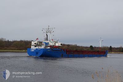
GT FORSETI
General Cargo
Current Trip
| Time Travelled | 2 days |
|---|---|
| Remaining Time | 2 days |
| Distance Travelled | 400.07 nm |
| Remaining Distance | 349.21 nm |
| AVG Speed | 7.4 Knots |
| MAX Speed | 9.4 Knots |
| AVG Wind | 11.3 knots |
| MAX Wind | 16.9 knots |
| MIN Temp | 3.1°C / 37.58°F |
| MAX Temp | 9.1°C / 48.38°F |
| Draught | 5.5 m |
| Position Received | Now |
Current Position
| Longitude | 9.70235° |
|---|---|
| Latitude | 54.29885° |
| Status | Under way using engine |
| Speed | 6.6 Knots |
| Course | 227.8° |
| Area | Baltic Sea |
| Station | T-AIS |
| Position Received | Now |
Info
Information
The current position of GT FORSETI is in Baltic Sea with coordinates 54.29885° / 9.70235° as reported on 2024-04-19 09:07 by AIS to our vessel tracker app. The vessel's current speed is 6.6 Knots and is heading at the port of TERNEUZEN. The estimated time of arrival as calculated by MyShipTracking vessel tracking app is 2024-04-21 14:05 LT
The vessel GT FORSETI (IMO: 9041320, MMSI: 304010297) is a General Cargo that was built in 1993 ( 31 years old ). It's sailing under the flag of [AG] Antigua Barbuda.
In this page you can find informations about the vessels current position, last detected port calls, and current voyage information. If the vessels is not in coverage by AIS you will find the latest position.
The current position of GT FORSETI is detected by our AIS receivers and we are not responsible for the reliability of the data. The last position was recorded while the vessel was in Coverage by the Ais receivers of our vessel tracking app.
The current draught of GT FORSETI as reported by AIS is 5.5 meters
Weather
| Temperature | 8.6°C / 47.48°F |
|---|---|
| Wind Speed | 13 knots |
| Direction | 281° W |
| Pressure | 999.4 hPa |
| Humidity | 82.9 % |
| Cloud Coverage | 100 % |
Featured Company
Last Port Calls
| Port | Arrival | Departure | Time In Port |
|---|---|---|---|
| 2024-04-13 13:53 | 2024-04-16 19:31 | 3 d | |
| 2024-04-10 22:02 | 2024-04-12 14:35 | 1 d | |
| 2024-04-05 14:44 | 2024-04-08 09:46 | 2 d | |
| 2024-03-29 20:07 | 2024-04-02 18:20 | 3 d | |
| 2024-03-29 19:03 | 2024-03-29 19:16 | 12 m | |
| 2024-03-22 16:53 | 2024-03-25 19:45 | 3 d | |
| 2024-03-18 00:58 | 2024-03-18 20:01 | 19 h | |
| 2024-03-10 17:24 | 2024-03-14 14:34 | 3 d | |
| 2024-03-04 18:21 | 2024-03-06 21:06 | 2 d | |
| 2024-02-22 06:27 | 2024-02-22 18:39 | 12 h |
Most Visited Ports (Last year)
| Port | Arrivals | |
|---|---|---|
| 6 | ||
| 6 | ||
| 6 | ||
| 5 | ||
| 4 | ||
| 3 |
Last Trips
| Origin | Departure | Destination | Arrival | Distance | |
|---|---|---|---|---|---|
| 2024-04-12 16:35 | 2024-04-13 15:53 | 224.66 nm | |||
| 2024-04-08 11:46 | 2024-04-11 00:02 | 510.72 nm | |||
| 2024-04-02 20:20 | 2024-04-05 16:44 | 107.61 nm | |||
| 2024-03-29 20:16 | 2024-03-29 21:07 | 7.11 nm | |||
| 2024-03-25 21:45 | 2024-03-29 20:03 | 763.11 nm | |||
| 2024-03-18 21:01 | 2024-03-22 18:53 | 728.99 nm | |||
| 2024-03-14 16:34 | 2024-03-18 01:58 | 709.75 nm | |||
| 2024-03-06 21:06 | 2024-03-10 19:24 | 809.29 nm | |||
| 2024-02-22 19:39 | 2024-03-04 18:21 | 1607.71 nm | |||
| 2024-02-19 14:25 | 2024-02-22 07:27 | 288.17 nm |
Events
| Time | Event | Details | Position / Dest | Info |
|---|---|---|---|---|
| 2024-04-19 07:27 | START Moving | 7.08 nm, West of KIEL |
54.34227 / 9.95881
GHENT
|
Speed: 3.1 kn Course: 256° |
| 2024-04-19 06:57 | STOP Moving | 6.91 nm, West of KIEL |
54.34296 / 9.96360
GHENT
|
Speed: 0.3 kn Course: 257° |
| 2024-04-19 05:51 | START Moving | 1.42 nm, South West of STICKENHΟRN SPORT |
54.36601 / 10.13967
GHENT
|
Speed: 3.5 kn Course: 283° |
| 2024-04-19 05:24 | STOP Moving | 1.36 nm, South West of STICKENHΟRN SPORT |
54.36556 / 10.14285
GHENT
|
Speed: 0.3 kn Course: 286° |
| 2024-04-19 03:29 | START Moving | 7.24 nm, North of WENDTORF |
54.53264 / 10.34841
GHENT
|
Speed: 3.3 kn Course: 277° |
| 2024-04-19 03:21 | Status Changed | Under way using engine At anchor |
54.53279 / 10.35022
GHENT
|
Speed: 0.4 kn Course: 165° |
| 2024-04-18 15:44 | STOP Moving | 7.28 nm, North of WENDTORF |
54.53229 / 10.35336
GHENT
|
Speed: 0.3 kn Course: 270° |
| 2024-04-18 15:38 | Status Changed | At anchor Under way using engine |
54.53270 / 10.35170
GHENT
|
Speed: 1 kn Course: 259° |
| 2024-04-18 14:35 | Change Sea Area | German part of the Baltic Sea Danish part of the Baltic Sea |
54.56671 / 10.55441
Baltic Sea
GHENT
|
Speed: 7.8 kn Course: 257.1° |
| 2024-04-18 13:26 | Detected in Sea | Danish part of the Baltic Sea |
54.58606 / 10.80419
Baltic Sea
GHENT
|
Speed: 7.6 kn Course: 264.1° |