
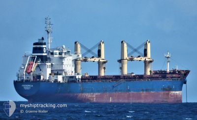
FEDERICA
Bulk Carrier
Current Trip
| Time Travelled | 7 days |
|---|---|
| Remaining Time | --- |
| Distance Travelled | 1025.11 nm |
| Remaining Distance | --- |
| AVG Speed | 11.5 Knots |
| MAX Speed | 13.5 Knots |
| AVG Wind | 15.7 knots |
| MAX Wind | 36.9 knots |
| MIN Temp | 2.1°C / 35.78°F |
| MAX Temp | 10.8°C / 51.44°F |
| Draught | 10.6 m |
| Position Received | Now |
Current Position
| Longitude | 9.94064° |
|---|---|
| Latitude | 57.82787° |
| Status | Under way using engine |
| Speed | 12.5 Knots |
| Course | 261.3° |
| Area | Skaggerak |
| Station | T-AIS |
| Position Received | Now |
Info
Information
The current position of FEDERICA is in Skaggerak with coordinates 57.82787° / 9.94064° as reported on 2024-04-16 22:44 by AIS to our vessel tracker app. The vessel's current speed is 12.5 Knots and is heading at the port of NEW ORLEANS. The estimated time of arrival as calculated by MyShipTracking vessel tracking app is 2024-05-04 11:00 LT
The vessel FEDERICA (IMO: 9612313, MMSI: 311000886) is a Bulk Carrier that was built in 2012 ( 12 years old ). It's sailing under the flag of [BS] Bahamas.
In this page you can find informations about the vessels current position, last detected port calls, and current voyage information. If the vessels is not in coverage by AIS you will find the latest position.
The current position of FEDERICA is detected by our AIS receivers and we are not responsible for the reliability of the data. The last position was recorded while the vessel was in Coverage by the Ais receivers of our vessel tracking app.
The current draught of FEDERICA as reported by AIS is 10.6 meters
Weather
| Temperature | 7°C / 44.6°F |
|---|---|
| Wind Speed | 6 knots |
| Direction | 1° N |
| Pressure | 1005.5 hPa |
| Humidity | 63.2 % |
| Cloud Coverage | 56 % |
Featured Company
Last Port Calls
| Port | Arrival | Departure | Time In Port |
|---|---|---|---|
| 2024-04-06 16:08 | 2024-04-09 21:24 | 3 d | |
| 2024-03-25 07:04 | 2024-03-27 18:27 | 2 d | |
| 2024-03-21 20:41 | 2024-03-24 18:47 | 2 d | |
| 2024-02-19 09:38 | 2024-02-24 18:37 | 5 d | |
| 2024-02-11 08:46 |
Most Visited Ports (Last year)
| Port | Arrivals | |
|---|---|---|
| 2 | ||
| 2 | ||
| 2 | ||
| 1 | ||
| 1 | ||
| 1 |
Last Trips
| Origin | Departure | Destination | Arrival | Distance | |
|---|---|---|---|---|---|
| 2024-03-27 18:27 | 2024-04-06 19:08 | 1684.86 nm | |||
| 2024-03-24 18:47 | 2024-03-25 07:04 | 110.89 nm | |||
| 2024-02-24 20:37 | 2024-03-21 20:41 | 3418.15 nm | |||
| 2024-02-11 11:46 | 2024-02-19 11:38 | 754.64 nm |
Events
| Time | Event | Details | Position / Dest | Info |
|---|---|---|---|---|
| 2024-04-16 22:06 | ETA Changed | 2024/05/04 11:00 2024/05/04 06:00 |
57.84302 / 10.19054
NEW ORLEANS
|
Speed: 12.2 kn Course: 263.6° |
| 2024-04-16 20:34 | Destination Changed | NEW ORLEANS SKAGEN |
57.82044 / 10.76147
NEW ORLEANS
|
Speed: 13 kn Course: 341.2° |
| 2024-04-16 20:34 | ETA Changed | 2024/05/04 06:00 2024/04/13 09:00 |
57.82044 / 10.76147
NEW ORLEANS
|
Speed: 13 kn Course: 341.2° |
| 2024-04-16 20:19 | Change Sea Area | Danish part of the Skaggerak Danish part of the Kattegat |
57.76920 / 10.77048
Skaggerak
|
Speed: 12.6 kn Course: 1.4° |
| 2024-04-16 19:19 | START Moving | 4.32 nm, South of SKAGEN |
57.64158 / 10.59787
SKAGEN
|
Speed: 3.1 kn Course: 305° |
| 2024-04-16 19:13 | Status Changed | Under way using engine At anchor |
57.64286 / 10.60186
SKAGEN
|
Speed: 0.4 kn Course: 202° |
| 2024-04-16 06:38 | Status Changed | At anchor Default |
57.64373 / 10.60155
SKAGEN
|
Speed: Course: 139° |
| 2024-04-16 06:35 | Status Changed | Default At anchor |
57.64366 / 10.60153
SKAGEN
|
Speed: Course: 136° |
| 2024-04-16 04:14 | Status Changed | At anchor Default |
57.64375 / 10.60204
SKAGEN
|
Speed: Course: 151° |
| 2024-04-16 04:11 | Status Changed | Default At anchor |
57.64377 / 10.60209
SKAGEN
|
Speed: Course: 152° |