
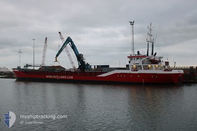
FAST SUS
General Cargo
Current Trip
| Time Travelled | 1 day |
|---|---|
| Remaining Time | 18 h, 35 mins |
| Distance Travelled | 150.38 nm |
| Remaining Distance | 145.70 nm |
| AVG Speed | 9 Knots |
| MAX Speed | 12.4 Knots |
| AVG Wind | 8.9 knots |
| MAX Wind | 12.6 knots |
| MIN Temp | 2.4°C / 36.32°F |
| MAX Temp | 7.8°C / 46.04°F |
| Draught | 4.7 m |
| Position Received | 1 m ago |
Current Position
| Longitude | 1.95481° |
|---|---|
| Latitude | 52.47529° |
| Status | Under way using engine |
| Speed | 8.2 Knots |
| Course | 326.9° |
| Area | North Sea |
| Station | T-AIS |
| Position Received | 1 m ago |
Info
Information
The current position of FAST SUS is in North Sea with coordinates 52.47529° / 1.95481° as reported on 2024-04-23 10:12 by AIS to our vessel tracker app. The vessel's current speed is 8.2 Knots and is heading at the port of GUNNESS. The estimated time of arrival as calculated by MyShipTracking vessel tracking app is 2024-04-24 04:48 LT
The vessel FAST SUS (IMO: 9136096, MMSI: 205482000) is a General Cargo that was built in 1996 ( 28 years old ). It's sailing under the flag of [BE] Belgium.
In this page you can find informations about the vessels current position, last detected port calls, and current voyage information. If the vessels is not in coverage by AIS you will find the latest position.
The current position of FAST SUS is detected by our AIS receivers and we are not responsible for the reliability of the data. The last position was recorded while the vessel was in Coverage by the Ais receivers of our vessel tracking app.
The current draught of FAST SUS as reported by AIS is 4.7 meters
Weather
| Temperature | 6.2°C / 43.16°F |
|---|---|
| Wind Speed | 11 knots |
| Direction | 242° WSW |
| Pressure | 1021.6 hPa |
| Humidity | 88.3 % |
| Cloud Coverage | 100 % |
Featured Company
Last Port Calls
| Port | Arrival | Departure | Time In Port |
|---|---|---|---|
| 2024-04-22 00:26 | 2024-04-22 01:54 | 1 h | |
| 2024-04-19 06:06 | 2024-04-19 14:12 | 8 h | |
| 2024-04-14 02:59 | 2024-04-16 19:13 | 2 d | |
| 2024-04-10 20:18 | 2024-04-12 18:57 | 1 d | |
| 2024-04-04 08:21 | 2024-04-07 12:14 | 3 d | |
| 2024-03-30 21:20 | 2024-03-30 21:26 | 5 m | |
| 2024-03-27 22:43 | 2024-03-29 01:40 | 1 d | |
| 2024-03-24 06:28 | 2024-03-26 18:13 | 2 d | |
| 2024-03-21 10:43 | 2024-03-21 12:14 | 1 h | |
| 2024-03-13 23:42 | 2024-03-15 00:59 | 1 d |
Most Visited Ports (Last year)
| Port | Arrivals | |
|---|---|---|
| 13 | ||
| 8 | ||
| 6 | ||
| 4 | ||
| 4 | ||
| 3 |
Last Trips
| Origin | Departure | Destination | Arrival | Distance | |
|---|---|---|---|---|---|
| 2024-04-19 16:12 | 2024-04-22 02:26 | 481.34 nm | |||
| 2024-04-16 21:13 | 2024-04-19 08:06 | 468.69 nm | |||
| 2024-04-12 19:57 | 2024-04-14 04:59 | 264.63 nm | |||
| 2024-04-07 14:14 | 2024-04-10 21:18 | 646.82 nm | |||
| 2024-03-30 22:26 | 2024-04-04 10:21 | 213.94 nm | |||
| 2024-03-29 02:40 | 2024-03-30 22:20 | 390.86 nm | |||
| 2024-03-26 18:13 | 2024-03-27 23:43 | 258.34 nm | |||
| 2024-03-21 13:14 | 2024-03-24 06:28 | 289.31 nm | |||
| 2024-03-15 01:59 | 2024-03-21 11:43 | 820.65 nm | |||
| 2024-03-12 18:22 | 2024-03-14 00:42 | 259.74 nm |
Events
| Time | Event | Details | Position / Dest | Info |
|---|---|---|---|---|
| 2024-04-23 07:55 | Change Sea Area | United Kingdom part of the North Sea Dutch part of the North Sea |
52.24332 / 2.25434
North Sea
GBGRW
|
Speed: 7.3 kn Course: 313.2° |
| 2024-04-23 07:55 | Status Changed | Under way using engine Default |
52.24332 / 2.25434
GBGRW
|
Speed: 7.5 kn Course: 312° |
| 2024-04-23 07:43 | IN Coverage |
52.24332 / 2.25434
North Sea
GBGRW
|
Speed: 7.3 kn Course: 313.2° |
|
| 2024-04-23 05:29 | Status Changed | Default Under way using engine |
52.02314 / 2.69245
GBGRW
|
Speed: 9.5 kn Course: 304.1° |
| 2024-04-23 05:24 | Status Changed | Under way using engine Default |
52.01555 / 2.71007
GBGRW
|
Speed: 9.7 kn Course: 308° |
| 2024-04-23 05:24 | OUT of Coverage |
52.01555 / 2.71007
North Sea
GBGRW
|
Speed: 9.5 kn Course: 304.1° |
|
| 2024-04-23 05:03 | Status Changed | Default Under way using engine |
51.98115 / 2.78699
GBGRW
|
Speed: 9.9 kn Course: 302° |
| 2024-04-22 18:25 | START Moving | 0.65 nm, South East of RUPELMONDE |
51.11873 / 4.30308
GBGRW
|
Speed: 3.1 kn Course: 17° |
| 2024-04-22 17:45 | STOP Moving | 0.86 nm, South East of RUPELMONDE |
51.11221 / 4.29984
GBGRW
|
Speed: 0.3 kn Course: 7° |
| 2024-04-22 17:34 | START Moving | 1.75 nm, South East of RUPELMONDE |
51.09997 / 4.31307
GBGRW
|
Speed: 3.8 kn Course: 305° |