
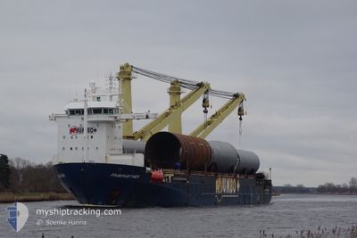
FAIRPARTNER
Heavy Load Carrier
Current Trip
| Time Travelled | 6 days |
|---|---|
| Remaining Time | --- |
| Distance Travelled | 1884.23 nm |
| Remaining Distance | --- |
| AVG Speed | 13.4 Knots |
| MAX Speed | 16.9 Knots |
| AVG Wind | 7.3 knots |
| MAX Wind | 14 knots |
| MIN Temp | 26.8°C / 80.24°F |
| MAX Temp | 30.6°C / 87.08°F |
| Draught | 5.8 m |
| Position Received | 11 h, 20 m ago |
Current Position
| Longitude | 105.47704° |
|---|---|
| Latitude | 3.17728° |
| Status | Under way using engine |
| Speed | 14.9 Knots |
| Course | 31.7° |
| Area | South China Sea |
| Station | T-AIS |
| Position Received | 11 h, 20 m ago |
Info
Information
The current position of FAIRPARTNER is in South China Sea with coordinates 3.17728° / 105.47704° as reported on 2024-04-15 20:15 by AIS to our vessel tracker app. The vessel's current speed is 14.9 Knots and is heading at the port of HUANGPU. The estimated time of arrival as calculated by MyShipTracking vessel tracking app is 2024-04-19 15:00 LT
The vessel FAIRPARTNER (IMO: 9243849, MMSI: 246467000) is a Heavy Load Carrier that was built in 2004 ( 20 years old ). It's sailing under the flag of [NL] Netherlands.
In this page you can find informations about the vessels current position, last detected port calls, and current voyage information. If the vessels is not in coverage by AIS you will find the latest position.
The current position of FAIRPARTNER is detected by our AIS receivers and we are not responsible for the reliability of the data. The last position was recorded while the vessel was in Coverage by the Ais receivers of our vessel tracking app.
The current draught of FAIRPARTNER as reported by AIS is 5.8 meters
Weather
| Temperature | 28.8°C / 83.84°F |
|---|---|
| Wind Speed | 10 knots |
| Direction | 70° ENE |
| Pressure | 1008.3 hPa |
| Humidity | 73.3 % |
| Cloud Coverage | 41 % |
Featured Company
Last Port Calls
| Port | Arrival | Departure | Time In Port |
|---|---|---|---|
| 2024-04-08 10:42 | 2024-04-09 13:56 | 1 d | |
| 2024-04-06 11:00 | 2024-04-08 04:36 | 1 d | |
| 2024-04-03 10:08 | 2024-04-05 12:03 | 2 d | |
| 2024-03-24 06:38 | 2024-03-25 04:18 | 21 h | |
| 2024-03-19 07:34 | 2024-03-23 08:42 | 4 d | |
| 2024-03-16 04:02 | 2024-03-18 06:08 | 2 d | |
| 2024-03-13 05:22 | 2024-03-15 08:43 | 2 d | |
| 2024-03-04 14:15 | 2024-03-11 06:46 | 6 d | |
| 2024-02-02 07:34 | 2024-02-03 19:30 | 1 d |
Most Visited Ports (Last year)
| Port | Arrivals | |
|---|---|---|
| 4 | ||
| 3 | ||
| 3 | ||
| 2 | ||
| 2 | ||
| 2 |
Last Trips
| Origin | Departure | Destination | Arrival | Distance | |
|---|---|---|---|---|---|
| 2024-04-08 10:06 | 2024-04-08 16:12 | 76.03 nm | |||
| 2024-04-05 17:33 | 2024-04-06 16:30 | 15.90 nm | |||
| 2024-03-25 08:18 | 2024-04-03 15:38 | 3123.77 nm | |||
| 2024-03-23 11:42 | 2024-03-24 10:38 | 327.20 nm | |||
| 2024-03-18 10:08 | 2024-03-19 10:34 | 378.76 nm | |||
| 2024-03-15 12:43 | 2024-03-16 08:02 | 12.26 nm | |||
| 2024-03-11 10:46 | 2024-03-13 09:22 | 193.38 nm | |||
| 2024-02-03 19:30 | 2024-03-04 18:15 | 9584.88 nm | |||
| 2024-01-23 15:03 | 2024-02-02 07:34 | 3000.83 nm |
Events
| Time | Event | Details | Position / Dest | Info |
|---|---|---|---|---|
| 2024-04-15 20:18 | Status Changed | Default Under way using engine |
3.18667 / 105.48333
HUANGPU
|
Speed: 14.9 kn Course: 31.7° |
| 2024-04-15 20:15 | Status Changed | Under way using engine Default |
3.17728 / 105.47704
HUANGPU
|
Speed: 14 kn Course: 32° |
| 2024-04-15 20:15 | OUT of Coverage |
3.17728 / 105.47704
South China Sea
HUANGPU
|
Speed: 14.9 kn Course: 31.7° |
|
| 2024-04-15 20:06 | Status Changed | Default Under way using engine |
3.14500 / 105.45667
HUANGPU
|
Speed: 14.9 kn Course: 32.2° |
| 2024-04-15 19:52 | Status Changed | Under way using engine Default |
3.09542 / 105.42592
HUANGPU
|
Speed: 14.9 kn Course: 33° |
| 2024-04-15 19:38 | Status Changed | Default Under way using engine |
3.04861 / 105.39631
HUANGPU
|
Speed: 14.9 kn Course: 34.3° |
| 2024-04-15 19:33 | Status Changed | Under way using engine Default |
3.02953 / 105.38370
HUANGPU
|
Speed: 14 kn Course: 30° |
| 2024-04-15 19:24 | Status Changed | Default Under way using engine |
2.99667 / 105.36166
HUANGPU
|
Speed: 14.8 kn Course: 30.4° |
| 2024-04-15 19:17 | Status Changed | Under way using engine Default |
2.97462 / 105.34949
HUANGPU
|
Speed: 14.7 kn Course: 37° |
| 2024-04-15 19:11 | Status Changed | Default Under way using engine |
2.95158 / 105.33568
HUANGPU
|
Speed: 14.6 kn Course: 39.9° |