
FACTOTUM
Cargo
Current Trip
ENGIS>
| Time Travelled | --- |
|---|---|
| Remaining Time | --- |
| Distance Travelled | --- |
| Remaining Distance | --- |
| AVG Speed | --- |
| MAX Speed | --- |
| AVG Wind | --- |
| MAX Wind | --- |
| MIN Temp | --- |
| MAX Temp | --- |
| Draught | 1.9 m |
| Position Received | 2 d ago |
Current Position
| Longitude | 4.74526° |
|---|---|
| Latitude | 51.33082° |
| Status | Under way using engine |
| Speed | 0.9 Knots |
| Course | --- |
| Area | North Sea |
| Station | T-AIS |
| Position Received | 2 d ago |
Info
Information
The current position of FACTOTUM is in North Sea with coordinates 51.33082° / 4.74526° as reported on 2024-04-18 06:29 by AIS to our vessel tracker app. The vessel's current speed is 0.9 Knots
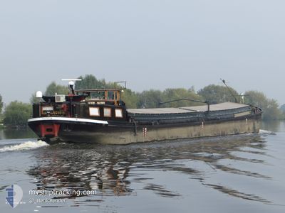
The vessel FACTOTUM (MMSI: 244660694) is a Cargo It's sailing under the flag of [NL] Netherlands.
In this page you can find informations about the vessels current position, last detected port calls, and current voyage information. If the vessels is not in coverage by AIS you will find the latest position.
The current position of FACTOTUM is detected by our AIS receivers and we are not responsible for the reliability of the data. The last position was recorded while the vessel was in Coverage by the Ais receivers of our vessel tracking app.
The current draught of FACTOTUM as reported by AIS is 1.9 meters
Weather
| Temperature | 3.4°C / 38.12°F |
|---|---|
| Wind Speed | 5 knots |
| Direction | 358° N |
| Pressure | 1019.1 hPa |
| Humidity | 89.1 % |
| Cloud Coverage | 46 % |
Featured Company
Most Visited Ports (Last year)
| Port | Arrivals | |
|---|---|---|
| 4 | ||
| 2 | ||
| 1 | ||
| 1 | ||
| 1 |
Last Trips
| Origin | Departure | Destination | Arrival | Distance |
|---|
Events
| Time | Event | Details | Position / Dest | Info |
|---|---|---|---|---|
| 2024-04-18 06:29 | OUT of Coverage |
51.33082 / 4.74526
North Sea
|
Speed: 0.9 kn Course: 330° |
|
| 2024-04-18 06:28 | IN Coverage |
51.33082 / 4.74526
North Sea
|
Speed: 0.9 kn Course: 330° |
|
| 2024-04-17 13:13 | OUT of Coverage |
51.32949 / 4.76904
North Sea
|
Speed: 2.5 kn Course: 267.9° |
|
| 2024-04-17 13:13 | IN Coverage |
51.32949 / 4.76904
North Sea
|
Speed: 2.5 kn Course: 267.9° |
|
| 2024-04-16 08:17 | OUT of Coverage |
50.79582 / 5.68692
North Sea
|
Speed: 5.9 kn Course: 335.7° |
|
| 2024-04-16 08:12 | IN Coverage |
50.78865 / 5.68932
North Sea
|
Speed: 5.8 kn Course: 358.9° |
|
| 2024-04-15 09:58 | OUT of Coverage |
50.78721 / 5.68984
North Sea
|
Speed: 7.9 kn Course: 197.5° |
|
| 2024-04-15 09:56 | START Moving | 0.54 nm, South West of WAOLENWIERT |
50.79131 / 5.69104
ENGIS> |
Speed: 7.8 kn Course: 180.1° |
| 2024-04-15 09:41 | STOP Moving | 0.48 nm, South West of WAOLENWIERT |
50.79328 / 5.69094
ENGIS> |
Speed: Course: 511° |
| 2024-04-15 08:50 | IN Coverage |
50.82064 / 5.69713
North Sea
|
Speed: 5.4 kn Course: 188.3° |