
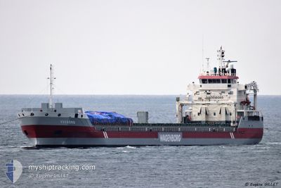
EXEBORG
General Cargo
Current Trip
| Trip Time | 30 mins |
|---|---|
| Trip Distance | 3.53 nm |
| AVG Speed | 6.8 Knots |
| MAX Speed | 9.5 Knots |
| Draught | 8.4 m |
| AVG Wind | 5.7 knots |
| MAX Wind | 5.9 knots |
| MIN Temp | 9.3°C / 48.74°F |
| MAX Temp | 9.7°C / 49.46°F |
| Position Received | 1 m ago |
Current Position
| Longitude | -8.33000° |
|---|---|
| Latitude | 51.83517° |
| Status | Moored |
| Speed | |
| Course | 142° |
| Area | Celtic Sea |
| Station | T-AIS |
| Position Received | 1 m ago |
Info
Information
The current position of EXEBORG is in Celtic Sea with coordinates 51.83517° / -8.33000° as reported on 2024-04-18 15:03 by AIS to our vessel tracker app. The vessel's current speed is 0 Knots and is currently inside the port of CORK.
The vessel EXEBORG (IMO: 9650482, MMSI: 244750716) is a General Cargo that was built in 2013 ( 11 years old ). It's sailing under the flag of [NL] Netherlands.
In this page you can find informations about the vessels current position, last detected port calls, and current voyage information. If the vessels is not in coverage by AIS you will find the latest position.
The current position of EXEBORG is detected by our AIS receivers and we are not responsible for the reliability of the data. The last position was recorded while the vessel was in Coverage by the Ais receivers of our vessel tracking app.
The current draught of EXEBORG as reported by AIS is 8.4 meters
Weather
| Temperature | 11.3°C / 52.34°F |
|---|---|
| Wind Speed | 10 knots |
| Direction | 243° WSW |
| Pressure | 1025.2 hPa |
| Humidity | 80.4 % |
| Cloud Coverage | 100 % |
Featured Company
Last Port Calls
| Port | Arrival | Departure | Time In Port |
|---|---|---|---|
| 2024-04-18 09:42 | |||
| 2024-04-18 09:04 | 2024-04-18 09:12 | 7 m | |
| 2024-04-07 09:52 | 2024-04-07 11:22 | 1 h | |
| 2024-04-06 01:18 | 2024-04-06 01:53 | 35 m | |
| 2024-04-01 00:19 | 2024-04-04 23:00 | 3 d | |
| 2024-03-28 13:31 | 2024-03-30 13:01 | 1 d | |
| 2024-03-25 12:30 | 2024-03-26 12:05 | 23 h | |
| 2024-03-24 04:18 | 2024-03-24 04:57 | 38 m | |
| 2024-03-21 08:19 | 2024-03-22 21:42 | 1 d | |
| 2024-03-04 11:45 | 2024-03-06 10:10 | 1 d |
Last Trips
| Origin | Departure | Destination | Arrival | Distance | |
|---|---|---|---|---|---|
| 2024-04-18 10:12 | 2024-04-18 10:42 | 3.53 nm | |||
| 2024-04-07 07:22 | 2024-04-18 10:04 | 2775.84 nm | |||
| 2024-04-05 21:53 | 2024-04-07 05:52 | 299.85 nm | |||
| 2024-04-04 19:00 | 2024-04-05 21:18 | 229.96 nm | |||
| 2024-03-30 08:01 | 2024-03-31 20:19 | 453.57 nm | |||
| 2024-03-26 08:05 | 2024-03-28 08:31 | 491.63 nm | |||
| 2024-03-24 00:57 | 2024-03-25 08:30 | 228.04 nm | |||
| 2024-03-22 17:42 | 2024-03-24 00:18 | 297.73 nm | |||
| 2024-03-06 12:10 | 2024-03-21 04:19 | 4023.59 nm | |||
| 2024-03-02 17:12 | 2024-03-04 13:45 | 381.91 nm |
Events
| Time | Event | Details | Position / Dest | Info |
|---|---|---|---|---|
| 2024-04-18 10:00 | Status Changed | Moored Under way using engine |
51.83517 / -8.33000
[IE] CORK
|
Speed: Course: 143° |
| 2024-04-18 09:42 | STOP Moving |
51.83600 / -8.32933
[IE] CORK
|
Speed: 0.3 kn Course: 187° |
|
| 2024-04-18 09:42 | PORT ARRIVAL |
|
51.83600 / -8.32933
[IE] CORK
|
Speed: 0.6 kn Course: 188° |
| 2024-04-18 09:12 | PORT DEPARTURE |
|
51.83583 / -8.26333
IERIN
|
Speed: 11 kn Course: 21° |
| 2024-04-18 09:04 | PORT ARRIVAL |
|
51.81417 / -8.27117
[IE] CORK
|
Speed: 11.2 kn Course: 333° |
| 2024-04-17 23:14 | Draught Changed | 8.4 8 |
51.27500 / -9.52767
IERIN
|
Speed: 6.4 kn Course: 77° |
| 2024-04-17 23:14 | ETA Changed | 2024/04/18 07:00 2024/04/19 08:00 |
51.27500 / -9.52767
IERIN
|
Speed: 6.4 kn Course: 77° |
| 2024-04-17 21:56 | Status Changed | Under way using engine Default |
51.24983 / -9.74217
IERIN
|
Speed: 6 kn Course: 81° |
| 2024-04-17 21:48 | Status Changed | Default Under way using engine |
51.24667 / -9.76167
IERIN
|
Speed: 6.2 kn Course: 81° |
| 2024-04-17 21:44 | Status Changed | Under way using engine Default |
51.24717 / -9.77433
IERIN
|
Speed: 6 kn Course: 83° |