
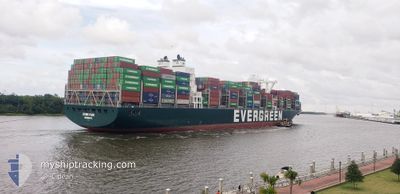
EVER FAIR
Cargo A
Current Trip
LAST UPDATE TIME
| Time Travelled | 5 days |
|---|---|
| Remaining Time | --- |
| Distance Travelled | 1892.41 nm |
| Remaining Distance | --- |
| AVG Speed | 14.7 Knots |
| MAX Speed | 23.1 Knots |
| AVG Wind | 10.9 knots |
| MAX Wind | 19.5 knots |
| MIN Temp | 9.2°C / 48.56°F |
| MAX Temp | 28.1°C / 82.58°F |
| Draught | 10.5 m |
| Position Received | 1 d ago |
Current Position
| Longitude | -74.67201° |
|---|---|
| Latitude | 18.81647° |
| Status | Under way using engine |
| Speed | 20.9 Knots |
| Course | 206° |
| Area | Caribbean Sea |
| Station | T-AIS |
| Position Received | 1 d ago |
Info
Information
The current position of EVER FAIR is in Caribbean Sea with coordinates 18.81647° / -74.67201° as reported on 2024-04-23 12:12 by AIS to our vessel tracker app. The vessel's current speed is 20.9 Knots
The vessel EVER FAIR (IMO: 9850886, MMSI: 636020536) is a Cargo A It's sailing under the flag of [LR] Liberia.
In this page you can find informations about the vessels current position, last detected port calls, and current voyage information. If the vessels is not in coverage by AIS you will find the latest position.
The current position of EVER FAIR is detected by our AIS receivers and we are not responsible for the reliability of the data. The last position was recorded while the vessel was in Coverage by the Ais receivers of our vessel tracking app.
The current draught of EVER FAIR as reported by AIS is 10.5 meters
Weather
| Temperature | 27.8°C / 82.04°F |
|---|---|
| Wind Speed | 18 knots |
| Direction | 20° NNE |
| Pressure | 1009.7 hPa |
| Humidity | 80.2 % |
| Cloud Coverage | 80 % |
Featured Company
Last Port Calls
| Port | Arrival | Departure | Time In Port |
|---|---|---|---|
| 2024-04-18 19:39 | 2024-04-20 05:18 | 1 d | |
| 2024-04-16 04:09 | 2024-04-17 12:25 | 1 d | |
| 2024-04-12 20:12 | 2024-04-13 18:02 | 21 h | |
| 2024-04-08 10:57 | 2024-04-09 23:50 | 1 d | |
| 2024-04-01 01:12 | 2024-04-01 22:38 | 21 h | |
| 2024-03-29 08:38 | 2024-03-30 02:28 | 17 h | |
| 2024-02-19 19:29 | 2024-02-20 17:43 | 22 h | |
| 2024-02-16 04:10 | 2024-02-16 19:18 | 15 h | |
| 2024-02-10 12:06 | 2024-02-11 08:58 | 20 h | |
| 2024-02-04 16:26 | 2024-02-06 03:49 | 1 d |
Last Trips
| Origin | Departure | Destination | Arrival | Distance | |
|---|---|---|---|---|---|
| 2024-04-17 08:25 | 2024-04-18 15:39 | 391.00 nm | |||
| 2024-04-13 14:02 | 2024-04-16 00:09 | 911.66 nm | |||
| 2024-04-09 19:50 | 2024-04-12 16:12 | 145.79 nm | |||
| 2024-04-01 17:38 | 2024-04-08 06:57 | 1588.47 nm | |||
| 2024-03-29 21:28 | 2024-03-31 20:12 | 72.48 nm | |||
| 2024-02-21 02:43 | 2024-03-29 03:38 | 8566.07 nm | |||
| 2024-02-17 03:18 | 2024-02-20 04:29 | 657.56 nm | |||
| 2024-02-11 16:58 | 2024-02-16 12:10 | 717.62 nm | |||
| 2024-02-06 11:49 | 2024-02-10 20:06 | 980.17 nm | |||
| 2024-01-22 07:52 | 2024-02-05 00:26 | 5639.68 nm |
Events
| Time | Event | Details | Position / Dest | Info |
|---|---|---|---|---|
| 2024-04-23 12:16 | Status Changed | Default Under way using engine |
18.79668 / -74.68201
LAST UPDATE TIME
|
Speed: 20.9 kn Course: 206° |
| 2024-04-23 12:12 | OUT of Coverage |
18.81647 / -74.67201
Caribbean Sea
|
Speed: 20.9 kn Course: 206° |
|
| 2024-04-23 10:40 | Change Sea Area | Haitian part of the Caribbean Sea Bahamas part of the North Atlantic Ocean |
19.34500 / -74.40495
Caribbean Sea
|
Speed: 22.3 kn Course: 209.1° |
| 2024-04-23 10:40 | Status Changed | Under way using engine Default |
19.34500 / -74.40495
LAST UPDATE TIME
|
Speed: 21.1 kn Course: 206° |
| 2024-04-23 10:24 | IN Coverage |
19.34500 / -74.40495
Caribbean Sea
|
Speed: 22.3 kn Course: 209.1° |
|
| 2024-04-23 04:14 | Status Changed | Default Under way using engine |
20.66278 / -73.94501
LAST UPDATE TIME
|
Speed: 11.7 kn Course: 198.2° |
| 2024-04-23 03:57 | OUT of Coverage |
20.71534 / -73.92624
North Atlantic Ocean
|
Speed: 11.7 kn Course: 198.2° |
|
| 2024-04-22 22:33 | Status Changed | Under way using engine Default |
21.71964 / -73.60498
LAST UPDATE TIME
|
Speed: 11.1 kn Course: 196° |
| 2024-04-22 22:17 | Status Changed | Default Under way using engine |
21.76559 / -73.59127
LAST UPDATE TIME
|
Speed: 11.2 kn Course: 196.4° |
| 2024-04-22 21:26 | Status Changed | Under way using engine Default |
21.91847 / -73.54182
LAST UPDATE TIME
|
Speed: 11.3 kn Course: 197° |