
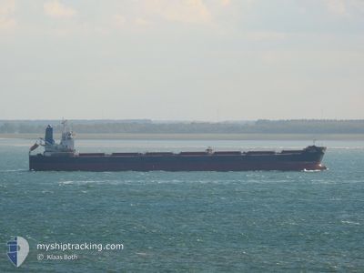
EVANGELISTRIA
Bulk Carrier
Current Trip
| Time Travelled | 9 days |
|---|---|
| Remaining Time | --- |
| Distance Travelled | 2710.89 nm |
| Remaining Distance | --- |
| AVG Speed | 11 Knots |
| MAX Speed | 14.4 Knots |
| AVG Wind | 19.1 knots |
| MAX Wind | 32.8 knots |
| MIN Temp | 7.1°C / 44.78°F |
| MAX Temp | 17.1°C / 62.78°F |
| Draught | 7.1 m |
| Position Received | 1 d ago |
Current Position
| Longitude | 14.84719° |
|---|---|
| Latitude | 36.37947° |
| Status | Under way using engine |
| Speed | 13.2 Knots |
| Course | 105.4° |
| Area | Mediterranean Sea - Eastern Basin |
| Station | T-AIS |
| Position Received | 1 d ago |
Info
Information
The current position of EVANGELISTRIA is in Mediterranean Sea - Eastern Basin with coordinates 36.37947° / 14.84719° as reported on 2024-04-24 07:36 by AIS to our vessel tracker app. The vessel's current speed is 13.2 Knots and is heading at the port of CANAKKALE. The estimated time of arrival as calculated by MyShipTracking vessel tracking app is 2024-04-26 20:00 LT
The vessel EVANGELISTRIA (IMO: 9383857, MMSI: 636020573) is a Bulk Carrier that was built in 2008 ( 16 years old ). It's sailing under the flag of [LR] Liberia.
In this page you can find informations about the vessels current position, last detected port calls, and current voyage information. If the vessels is not in coverage by AIS you will find the latest position.
The current position of EVANGELISTRIA is detected by our AIS receivers and we are not responsible for the reliability of the data. The last position was recorded while the vessel was in Coverage by the Ais receivers of our vessel tracking app.
The current draught of EVANGELISTRIA as reported by AIS is 7.1 meters
Weather
| Temperature | 15.9°C / 60.62°F |
|---|---|
| Wind Speed | 23 knots |
| Direction | 294° WNW |
| Pressure | 1010.4 hPa |
| Humidity | 66.3 % |
| Cloud Coverage | 31 % |
Featured Company
Last Port Calls
| Port | Arrival | Departure | Time In Port |
|---|---|---|---|
| 2024-04-05 10:50 | 2024-04-15 20:48 | 10 d | |
| 2024-03-29 12:22 | 2024-03-29 16:47 | 4 h | |
| 2024-03-22 03:44 | 2024-03-22 04:58 | 1 h | |
| 2024-03-10 13:55 | 2024-03-17 14:20 | 7 d | |
| 2024-02-20 06:54 | 2024-02-24 04:42 | 3 d | |
| 2024-02-13 16:23 | 2024-02-19 22:03 | 6 d | |
| 2024-02-03 05:33 |
Last Trips
| Origin | Departure | Destination | Arrival | Distance | |
|---|---|---|---|---|---|
| 2024-03-29 17:47 | 2024-04-05 12:50 | 1469.00 nm | |||
| 2024-03-22 07:58 | 2024-03-29 13:22 | 1766.65 nm | |||
| 2024-03-17 16:20 | 2024-03-22 06:44 | 363.74 nm | |||
| 2024-02-24 05:42 | 2024-03-10 15:55 | 1997.19 nm | |||
| 2024-02-19 23:03 | 2024-02-20 07:54 | 66.73 nm | |||
| 2024-02-03 07:33 | 2024-02-13 17:23 | 1905.51 nm |
Events
| Time | Event | Details | Position / Dest | Info |
|---|---|---|---|---|
| 2024-04-24 07:50 | Status Changed | Default Under way using engine |
36.36577 / 14.90938
CANAKKALE STRAIT
|
Speed: 13.2 kn Course: 105.4° |
| 2024-04-24 07:36 | OUT of Coverage |
36.37947 / 14.84719
Mediterranean Sea - Eastern Basin
CANAKKALE STRAIT
|
Speed: 13.2 kn Course: 105.4° |
|
| 2024-04-24 05:02 | Status Changed | Under way using engine Default |
36.53266 / 14.19828
CANAKKALE STRAIT
|
Speed: 12.4 kn Course: 106° |
| 2024-04-24 04:49 | Status Changed | Default Under way using engine |
36.54458 / 14.14595
CANAKKALE STRAIT
|
Speed: 12.4 kn Course: 106.6° |
| 2024-04-24 04:26 | Change Sea Area | Italian part of the Mediterranean Sea - Eastern Basin Algerian part of the Mediterranean Sea - Western Basin |
36.56820 / 14.05071
Mediterranean Sea - Eastern Basin
CANAKKALE STRAIT
|
Speed: 12.2 kn Course: 107.5° |
| 2024-04-24 04:26 | Status Changed | Under way using engine Default |
36.56820 / 14.05071
CANAKKALE STRAIT
|
Speed: 12 kn Course: 107° |
| 2024-04-24 04:15 | IN Coverage |
36.56820 / 14.05071
Mediterranean Sea - Eastern Basin
CANAKKALE STRAIT
|
Speed: 12.2 kn Course: 107.5° |
|
| 2024-04-21 19:45 | Status Changed | Default Under way using engine |
36.68333 / .24167
CANAKKALE STRAIT
|
Speed: 11 kn Course: 79.2° |
| 2024-04-21 19:42 | Status Changed | Under way using engine Default |
36.68163 / .23110
CANAKKALE STRAIT
|
Speed: 10 kn Course: 78° |
| 2024-04-21 19:42 | OUT of Coverage |
36.68163 / .23110
Mediterranean Sea - Western Basin
CANAKKALE STRAIT
|
Speed: 11 kn Course: 79.2° |