
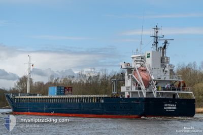
ESTEMAR
General Cargo
Current Trip
| Trip Time | 7 h, 33 mins |
|---|---|
| Trip Distance | 81.32 nm |
| AVG Speed | 11.2 Knots |
| MAX Speed | 12.3 Knots |
| Draught | 6.3 m |
| AVG Wind | 15.1 knots |
| MAX Wind | 20.4 knots |
| MIN Temp | -3.8°C / 25.16°F |
| MAX Temp | 0.3°C / 32.54°F |
| Position Received | 3 d ago |
Current Position
| Longitude | 20.88871° |
|---|---|
| Latitude | 63.55579° |
| Status | Under way using engine |
| Speed | 7.5 Knots |
| Course | 75.7° |
| Area | Gulf of Bothnia |
| Station | T-AIS |
| Position Received | 3 d ago |
Info
Information
The current position of ESTEMAR is in Gulf of Bothnia with coordinates 63.55579° / 20.88871° as reported on 2024-04-21 10:07 by AIS to our vessel tracker app. The vessel's current speed is 7.5 Knots and is currently inside the port of VIRPIPERA.
The vessel ESTEMAR (IMO: 9552068, MMSI: 253361000) is a General Cargo that was built in 2011 ( 13 years old ). It's sailing under the flag of [LU] Luxembourg.
In this page you can find informations about the vessels current position, last detected port calls, and current voyage information. If the vessels is not in coverage by AIS you will find the latest position.
The current position of ESTEMAR is detected by our AIS receivers and we are not responsible for the reliability of the data. The last position was recorded while the vessel was in Coverage by the Ais receivers of our vessel tracking app.
The current draught of ESTEMAR as reported by AIS is 6.3 meters
Weather
| Temperature | 1.6°C / 34.88°F |
|---|---|
| Wind Speed | 6 knots |
| Direction | 130° SE |
| Pressure | 1015.2 hPa |
| Humidity | 83.8 % |
| Cloud Coverage | 100 % |
Featured Company
Last Port Calls
| Port | Arrival | Departure | Time In Port |
|---|---|---|---|
| 2024-04-23 14:45 | |||
| 2024-04-22 05:28 | 2024-04-23 07:12 | 1 d | |
| 2024-04-12 21:42 | 2024-04-15 20:53 | 2 d | |
| 2024-04-11 04:37 | 2024-04-12 04:10 | 23 h | |
| 2024-04-09 06:21 | 2024-04-09 07:02 | 41 m | |
| 2024-04-05 19:26 | 2024-04-07 08:31 | 1 d | |
| 2024-03-18 17:14 | 2024-04-04 12:14 | 16 d | |
| 2024-03-16 07:59 | 2024-03-17 05:43 | 21 h | |
| 2024-03-03 17:46 | 2024-03-05 21:32 | 2 d | |
| 2024-02-20 09:45 | 2024-03-02 23:58 | 11 d |
Last Trips
| Origin | Departure | Destination | Arrival | Distance | |
|---|---|---|---|---|---|
| 2024-04-23 09:12 | 2024-04-23 17:45 | 81.32 nm | |||
| 2024-04-15 22:53 | 2024-04-22 07:28 | 1387.04 nm | |||
| 2024-04-12 06:10 | 2024-04-12 23:42 | 173.33 nm | |||
| 2024-04-09 09:02 | 2024-04-11 06:37 | 354.03 nm | |||
| 2024-04-07 10:31 | 2024-04-09 08:21 | 432.41 nm | |||
| 2024-04-04 14:14 | 2024-04-05 21:26 | 323.30 nm | |||
| 2024-03-17 06:43 | 2024-03-18 18:14 | 366.81 nm | |||
| 2024-03-05 23:32 | 2024-03-16 08:59 | 973.60 nm | |||
| 2024-03-03 01:58 | 2024-03-03 19:46 | 155.83 nm | |||
| 2024-02-15 01:04 | 2024-02-20 11:45 | 962.30 nm |
Events
| Time | Event | Details | Position / Dest | Info |
|---|---|---|---|---|
| 2024-04-23 14:59 | STOP Moving |
64.65414 / 24.41014
[FI] VIRPIPERA
|
Speed: Course: 359° |
|
| 2024-04-23 14:45 | PORT ARRIVAL |
|
64.65687 / 24.40941
[FI] VIRPIPERA
|
Speed: 3.5 kn Course: 90° |
| 2024-04-23 07:44 | START Moving | 7.95 nm, South East of LULEA |
65.49082 / 22.41327
SELLA
|
Speed: 10.9 kn Course: 130° |
| 2024-04-23 07:40 | STOP Moving | 7.46 nm, South East of LULEA |
65.49590 / 22.39783
SELLA
|
Speed: 0.3 kn Course: 134° |
| 2024-04-23 07:12 | PORT DEPARTURE |
|
65.53918 / 22.30518
SELLA
|
Speed: 9.8 kn Course: 107° |
| 2024-04-23 07:04 | START Moving |
65.54555 / 22.25589
[SE] LULEA
|
Speed: 8 kn Course: 103° |
|
| 2024-04-22 05:52 | STOP Moving |
65.54775 / 22.24661
[SE] LULEA
|
Speed: Course: 287° |
|
| 2024-04-22 05:28 | PORT ARRIVAL |
|
65.54408 / 22.27439
[SE] LULEA
|
Speed: 7.6 kn Course: 288° |
| 2024-04-22 04:48 | START Moving | 8.35 nm, South East of LULEA |
65.48679 / 22.42570
SELLA
|
Speed: 8 kn Course: 309° |
| 2024-04-22 04:40 | STOP Moving | 8.79 nm, South East of LULEA |
65.48216 / 22.43953
SELLA
|
Speed: Course: 312° |