
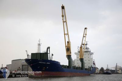
INDUSTRIAL EMMA
General Cargo
Current Trip
CIABJ
| Time Travelled | 3 days |
|---|---|
| Remaining Time | --- |
| Distance Travelled | 862.36 nm |
| Remaining Distance | --- |
| AVG Speed | 11.3 Knots |
| MAX Speed | 12.3 Knots |
| AVG Wind | 9.1 knots |
| MAX Wind | 25.4 knots |
| MIN Temp | 26°C / 78.8°F |
| MAX Temp | 29.6°C / 85.28°F |
| Draught | 7.1 m |
| Position Received | 16 d ago |
Current Position
| Longitude | -41.14081° |
|---|---|
| Latitude | -22.56975° |
| Status | Under way using engine |
| Speed | 12.4 Knots |
| Course | 47.7° |
| Area | South Atlantic Ocean |
| Station | T-AIS |
| Position Received | 16 d ago |
Info
Information
The current position of INDUSTRIAL EMMA is in South Atlantic Ocean with coordinates -22.56975° / -41.14081° as reported on 2024-04-03 21:07 by AIS to our vessel tracker app. The vessel's current speed is 12.4 Knots
The vessel INDUSTRIAL EMMA (IMO: 9474371, MMSI: 305514000) is a General Cargo that was built in 2009 ( 15 years old ). It's sailing under the flag of [AG] Antigua Barbuda.
In this page you can find informations about the vessels current position, last detected port calls, and current voyage information. If the vessels is not in coverage by AIS you will find the latest position.
The current position of INDUSTRIAL EMMA is detected by our AIS receivers and we are not responsible for the reliability of the data. The last position was recorded while the vessel was in Coverage by the Ais receivers of our vessel tracking app.
The current draught of INDUSTRIAL EMMA as reported by AIS is 7.1 meters
Weather
| Temperature | 26°C / 78.8°F |
|---|---|
| Wind Speed | 14 knots |
| Direction | 220° SW |
| Pressure | 1009.9 hPa |
| Humidity | 89.5 % |
| Cloud Coverage | 83 % |
Featured Company
Last Port Calls
| Port | Arrival | Departure | Time In Port |
|---|---|---|---|
| 2024-04-16 04:25 | 2024-04-16 18:29 | 14 h | |
| 2024-03-21 08:04 | 2024-04-03 10:17 | 13 d | |
| 2024-03-17 09:05 | 2024-03-17 09:10 | 5 m | |
| 2024-03-13 11:43 | 2024-03-13 11:53 | 10 m | |
| 2024-03-09 00:07 | 2024-03-10 00:00 | 23 h | |
| 2024-02-24 11:54 | 2024-02-25 06:51 | 18 h | |
| 2024-02-22 07:17 | 2024-02-22 17:21 | 10 h | |
| 2024-02-10 04:38 | 2024-02-13 05:12 | 3 d |
Most Visited Ports (Last year)
| Port | Arrivals | |
|---|---|---|
| 6 | ||
| 6 | ||
| 5 | ||
| 4 | ||
| 4 | ||
| 3 |
Last Trips
| Origin | Departure | Destination | Arrival | Distance | |
|---|---|---|---|---|---|
| 2024-04-03 07:17 | 2024-04-16 04:25 | 2954.47 nm | |||
| 2024-03-17 06:10 | 2024-03-21 05:04 | 4.31 nm | |||
| 2024-03-13 08:53 | 2024-03-17 06:05 | 406.52 nm | |||
| 2024-03-09 21:00 | 2024-03-13 08:43 | 231.00 nm | |||
| 2024-02-25 02:51 | 2024-03-08 21:07 | 3025.12 nm | |||
| 2024-02-22 13:21 | 2024-02-24 07:54 | 397.73 nm | |||
| 2024-02-12 23:12 | 2024-02-22 03:17 | 2288.80 nm | |||
| 2024-01-29 08:40 | 2024-02-09 22:38 | 2766.63 nm |
Events
| Time | Event | Details | Position / Dest | Info |
|---|---|---|---|---|
| 2024-04-16 18:29 | PORT DEPARTURE |
|
5.24542 / -3.99831
CIABJ
|
Speed: 11 kn Course: 129° |
| 2024-04-16 18:02 | START Moving |
5.29906 / -4.02275
[CI] ABIDJAN
|
Speed: 5.4 kn Course: 181° |
|
| 2024-04-16 05:13 | STOP Moving |
5.30073 / -4.02434
[CI] ABIDJAN
|
Speed: 0.3 kn Course: 75° |
|
| 2024-04-16 04:25 | PORT ARRIVAL |
|
5.24923 / -4.00244
[CI] ABIDJAN
|
Speed: 8.7 kn Course: 321° |
| 2024-04-15 20:53 | START Moving |
5.00485 / -3.72883
CIABJ
|
Speed: 5.9 kn Course: 251° |
|
| 2024-04-14 07:15 | STOP Moving | 19.45 nm, South of ABIDJAN |
4.99172 / -4.05182
CIABJ
|
Speed: 0.2 kn Course: 244° |
| 2024-04-13 14:37 | START Moving |
3.43834 / -6.28728
CIABJ
|
Speed: 5.8 kn Course: 63° |
|
| 2024-04-13 13:07 | STOP Moving |
3.42287 / -6.29715
CIABJ
|
Speed: 0.1 kn Course: 286° |