
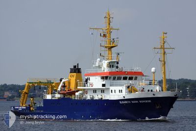
ELISABETH M. BORGESE
Naval Research Vessel
Current Trip
BALTIC RESEARCH
| Time Travelled | 6 days |
|---|---|
| Remaining Time | --- |
| Distance Travelled | 693.91 nm |
| Remaining Distance | --- |
| AVG Speed | 4.7 Knots |
| MAX Speed | 8.6 Knots |
| AVG Wind | 13.5 knots |
| MAX Wind | 25.6 knots |
| MIN Temp | 3.6°C / 38.48°F |
| MAX Temp | 12.9°C / 55.22°F |
| Draught | 3.9 m |
| Position Received | Now |
Current Position
| Longitude | 10.74572° |
|---|---|
| Latitude | 54.53186° |
| Status | Restricted manoeuverability |
| Speed | 5 Knots |
| Course | 271.5° |
| Area | Baltic Sea |
| Station | T-AIS |
| Position Received | Now |
Info
Information
The current position of ELISABETH M. BORGESE is in Baltic Sea with coordinates 54.53186° / 10.74572° as reported on 2024-04-19 13:28 by AIS to our vessel tracker app. The vessel's current speed is 5 Knots
The vessel ELISABETH M. BORGESE (IMO: 8521438, MMSI: 218601000) is a Naval Research Vessel that was built in 1987 ( 37 years old ). It's sailing under the flag of [DE] Germany.
In this page you can find informations about the vessels current position, last detected port calls, and current voyage information. If the vessels is not in coverage by AIS you will find the latest position.
The current position of ELISABETH M. BORGESE is detected by our AIS receivers and we are not responsible for the reliability of the data. The last position was recorded while the vessel was in Coverage by the Ais receivers of our vessel tracking app.
The current draught of ELISABETH M. BORGESE as reported by AIS is 3.9 meters
Weather
| Temperature | 8.2°C / 46.76°F |
|---|---|
| Wind Speed | 8 knots |
| Direction | 313° NW |
| Pressure | 997.4 hPa |
| Humidity | 80.8 % |
| Cloud Coverage | 100 % |
Featured Company
Last Port Calls
| Port | Arrival | Departure | Time In Port |
|---|---|---|---|
| 2024-04-10 05:03 | 2024-04-13 07:41 | 3 d | |
| 2024-04-03 05:00 | 2024-04-06 06:51 | 3 d | |
| 2024-03-28 09:37 | 2024-03-29 11:17 | 1 d | |
| 2024-03-15 12:06 | 2024-03-19 08:21 | 3 d | |
| 2024-03-13 13:05 | 2024-03-14 07:56 | 18 h | |
| 2024-03-01 05:59 | 2024-03-12 07:43 | 11 d | |
| 2024-02-21 06:04 | 2024-02-26 07:49 | 5 d | |
| 2024-02-10 17:32 | 2024-02-12 05:07 | 1 d | |
| 2024-02-09 10:30 | 2024-02-10 07:18 | 20 h | |
| 2024-02-03 06:00 | 2024-02-07 12:00 | 4 d |
Last Trips
| Origin | Departure | Destination | Arrival | Distance | |
|---|---|---|---|---|---|
| 2024-04-06 08:51 | 2024-04-10 07:03 | 306.02 nm | |||
| 2024-03-29 12:17 | 2024-04-03 07:00 | 657.13 nm | |||
| 2024-03-19 09:21 | 2024-03-28 10:37 | 1293.53 nm | |||
| 2024-03-14 08:56 | 2024-03-15 13:06 | 101.29 nm | |||
| 2024-03-12 08:43 | 2024-03-13 14:05 | 70.98 nm | |||
| 2024-02-26 08:49 | 2024-03-01 06:59 | 323.66 nm | |||
| 2024-02-12 06:07 | 2024-02-21 07:04 | 1201.30 nm | |||
| 2024-02-10 08:18 | 2024-02-10 18:32 | 90.28 nm | |||
| 2024-02-07 13:00 | 2024-02-09 11:30 | 295.03 nm | |||
| 2024-02-01 16:56 | 2024-02-03 07:00 | 294.36 nm |
Events
| Time | Event | Details | Position / Dest | Info |
|---|---|---|---|---|
| 2024-04-18 15:52 | START Moving | 13.69 nm, North West of HEILIGENHAFEN |
54.53916 / 10.74001
BALTIC RESEARCH
|
Speed: 5.5 kn Course: 88° |
| 2024-04-18 15:43 | STOP Moving | 13.73 nm, North West of HEILIGENHAFEN |
54.53833 / 10.73715
BALTIC RESEARCH
|
Speed: 0.3 kn Course: 301° |
| 2024-04-18 14:37 | START Moving | 12.65 nm, North West of HEILIGENHAFEN |
54.53005 / 10.76704
BALTIC RESEARCH
|
Speed: 4.2 kn Course: 269° |
| 2024-04-18 14:20 | STOP Moving | 12.64 nm, North West of HEILIGENHAFEN |
54.53119 / 10.76963
BALTIC RESEARCH
|
Speed: 0.3 kn Course: 297° |
| 2024-04-17 14:00 | Status Changed | Restricted manoeuverability Under way using engine |
54.53941 / 10.73881
BALTIC RESEARCH
|
Speed: 4.4 kn Course: 123° |
| 2024-04-17 11:05 | Detected in Sea | German part of the Baltic Sea |
54.56433 / 11.32783
Baltic Sea
BALTIC RESEARCH
|
Speed: 7.8 kn Course: 296.8° |
| 2024-04-17 08:20 | Change Sea Area | Danish part of the Baltic Sea German part of the Baltic Sea |
54.36924 / 11.83472
Baltic Sea
BALTIC RESEARCH
|
Speed: 7.6 kn Course: 321.2° |
| 2024-04-17 06:33 | START Moving | 4.08 nm, North of ROSTOCK |
54.19491 / 12.07779
BALTIC RESEARCH
|
Speed: 4.2 kn Course: 323° |
| 2024-04-17 05:38 | STOP Moving | 3.98 nm, North of ROSTOCK |
54.19331 / 12.07967
BALTIC RESEARCH
|
Speed: 0.3 kn Course: 27° |
| 2024-04-17 03:56 | START Moving | 1.35 nm, North East of KUEHLUNGSBORN |
54.16609 / 11.80240
BALTIC RESEARCH
|
Speed: 3.1 kn Course: 327° |