
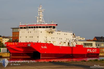
ELBEPILOT
Pilot Ship
Current Trip
ELBE PILOT
| Time Travelled | 2 days |
|---|---|
| Remaining Time | --- |
| Distance Travelled | 136.67 nm |
| Remaining Distance | --- |
| AVG Speed | 5.5 Knots |
| MAX Speed | 13.7 Knots |
| AVG Wind | 13.7 knots |
| MAX Wind | 22.9 knots |
| MIN Temp | 6.2°C / 43.16°F |
| MAX Temp | 9.5°C / 49.1°F |
| Draught | 6.2 m |
| Position Received | Now |
Current Position
| Longitude | 8.29392° |
|---|---|
| Latitude | 53.99567° |
| Status | Under way using engine |
| Speed | 1.1 Knots |
| Course | 149° |
| Area | North Sea |
| Station | T-AIS |
| Position Received | Now |
Info
Information
The current position of ELBEPILOT is in North Sea with coordinates 53.99567° / 8.29392° as reported on 2024-04-19 00:47 by AIS to our vessel tracker app. The vessel's current speed is 1.1 Knots
The vessel ELBEPILOT (IMO: 9514793, MMSI: 211464420) is a Pilot Ship that was built in 2009 ( 15 years old ). It's sailing under the flag of [DE] Germany.
In this page you can find informations about the vessels current position, last detected port calls, and current voyage information. If the vessels is not in coverage by AIS you will find the latest position.
The current position of ELBEPILOT is detected by our AIS receivers and we are not responsible for the reliability of the data. The last position was recorded while the vessel was in Coverage by the Ais receivers of our vessel tracking app.
The current draught of ELBEPILOT as reported by AIS is 6.2 meters
Weather
| Temperature | 6.3°C / 43.34°F |
|---|---|
| Wind Speed | 19 knots |
| Direction | 220° SW |
| Pressure | 1009.4 hPa |
| Humidity | 90 % |
| Cloud Coverage | 100 % |
Featured Company
Last Port Calls
| Port | Arrival | Departure | Time In Port |
|---|---|---|---|
| 2024-04-16 09:19 | 2024-04-16 11:38 | 2 h | |
| 2024-04-03 09:47 | 2024-04-03 13:18 | 3 h | |
| 2024-03-19 10:32 | 2024-03-19 15:32 | 5 h | |
| 2024-03-05 11:02 | 2024-03-05 15:56 | 4 h | |
| 2024-02-20 10:36 | 2024-02-20 14:24 | 3 h | |
| 2024-02-06 08:00 | 2024-02-06 14:06 | 6 h |
Most Visited Ports (Last year)
| Port | Arrivals | |
|---|---|---|
| 22 | ||
| 1 |
Last Trips
| Origin | Departure | Destination | Arrival | Distance | |
|---|---|---|---|---|---|
| 2024-04-03 15:18 | 2024-04-16 11:19 | 827.63 nm | |||
| 2024-03-19 16:32 | 2024-04-03 11:47 | 739.10 nm | |||
| 2024-03-05 16:56 | 2024-03-19 11:32 | 856.18 nm | |||
| 2024-02-20 15:24 | 2024-03-05 12:02 | 803.48 nm | |||
| 2024-02-06 15:06 | 2024-02-20 11:36 | 910.27 nm | |||
| 2024-01-23 13:22 | 2024-02-06 09:00 | 596.87 nm |
Events
| Time | Event | Details | Position / Dest | Info |
|---|---|---|---|---|
| 2024-04-19 00:23 | STOP Moving | 16.68 nm, North West of CUXHAVEN |
53.99659 / 8.29326
ELBE PILOT
|
Speed: 0.2 kn Course: 160° |
| 2024-04-19 00:04 | START Moving | 16.91 nm, South East of HELGOLAND |
53.99850 / 8.27164
ELBE PILOT
|
Speed: 3.2 kn Course: 264° |
| 2024-04-18 23:16 | STOP Moving | 16.8 nm, North West of CUXHAVEN |
53.99911 / 8.29176
ELBE PILOT
|
Speed: 0.2 kn Course: 178° |
| 2024-04-18 21:28 | IN Coverage |
53.99848 / 8.25936
North Sea
|
Speed: 9.6 kn Course: 6.4° |
|
| 2024-04-18 19:13 | OUT of Coverage |
53.99742 / 8.19373
North Sea
|
Speed: 2.2 kn Course: 33.7° |
|
| 2024-04-18 17:50 | START Moving | 15.4 nm, South East of HELGOLAND |
53.99696 / 8.21266
ELBE PILOT
|
Speed: 5.2 kn Course: 262.4° |
| 2024-04-18 16:39 | STOP Moving | 15.76 nm, South East of HELGOLAND |
53.99760 / 8.22764
ELBE PILOT
|
Speed: 0.3 kn Course: 278° |
| 2024-04-18 14:11 | START Moving | 15.34 nm, South East of HELGOLAND |
53.99791 / 8.21198
ELBE PILOT
|
Speed: 6.9 kn Course: 254.9° |
| 2024-04-18 13:25 | STOP Moving | 16.1 nm, South East of HELGOLAND |
53.99626 / 8.23845
ELBE PILOT
|
Speed: 0.3 kn Course: 285° |
| 2024-04-18 10:47 | START Moving | 14.58 nm, South East of HELGOLAND |
53.99763 / 8.18130
ELBE PILOT
|
Speed: 6 kn Course: 72.5° |