
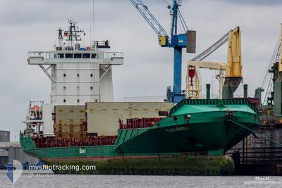
ELBCARRIER
Container Ship
Current Trip
| Time Travelled | 1 day |
|---|---|
| Remaining Time | 5 h, 11 mins |
| Distance Travelled | 558.27 nm |
| Remaining Distance | 82.02 nm |
| AVG Speed | 16.1 Knots |
| MAX Speed | 19.6 Knots |
| AVG Wind | 11.9 knots |
| MAX Wind | 21.5 knots |
| MIN Temp | 7°C / 44.6°F |
| MAX Temp | 10.2°C / 50.36°F |
| Draught | 6.3 m |
| Position Received | 1 m ago |
Current Position
| Longitude | 2.25434° |
|---|---|
| Latitude | 51.50972° |
| Status | Under way using engine |
| Speed | 14.5 Knots |
| Course | 47.4° |
| Area | North Sea |
| Station | T-AIS |
| Position Received | 1 m ago |
Info
Information
The current position of ELBCARRIER is in North Sea with coordinates 51.50972° / 2.25434° as reported on 2024-04-25 19:48 by AIS to our vessel tracker app. The vessel's current speed is 14.5 Knots and is heading at the port of ROTTERDAM. The estimated time of arrival as calculated by MyShipTracking vessel tracking app is 2024-04-26 01:00 LT
The vessel ELBCARRIER (IMO: 9388510, MMSI: 212935000) is a Container Ship that was built in 2007 ( 17 years old ). It's sailing under the flag of [CY] Cyprus.
In this page you can find informations about the vessels current position, last detected port calls, and current voyage information. If the vessels is not in coverage by AIS you will find the latest position.
The current position of ELBCARRIER is detected by our AIS receivers and we are not responsible for the reliability of the data. The last position was recorded while the vessel was in Coverage by the Ais receivers of our vessel tracking app.
The current draught of ELBCARRIER as reported by AIS is 6.3 meters
Weather
| Temperature | 7.8°C / 46.04°F |
|---|---|
| Wind Speed | 10 knots |
| Direction | 317° NW |
| Pressure | 1001.6 hPa |
| Humidity | 86.6 % |
| Cloud Coverage | 100 % |
Featured Company
Last Port Calls
| Port | Arrival | Departure | Time In Port |
|---|---|---|---|
| 2024-04-22 14:28 | 2024-04-24 09:49 | 1 d | |
| 2024-04-19 10:14 | 2024-04-20 17:15 | 1 d | |
| 2024-04-15 21:40 | 2024-04-17 14:21 | 1 d | |
| 2024-04-12 16:04 | 2024-04-13 22:13 | 1 d | |
| 2024-04-08 18:16 | 2024-04-10 21:24 | 2 d | |
| 2024-04-05 04:08 | 2024-04-06 12:52 | 1 d | |
| 2024-04-01 15:31 | 2024-04-03 08:44 | 1 d | |
| 2024-03-29 16:47 | 2024-03-30 18:54 | 1 d | |
| 2024-03-25 09:32 | 2024-03-27 00:27 | 1 d | |
| 2024-03-22 02:27 | 2024-03-23 10:19 | 1 d |
Most Visited Ports (Last year)
| Port | Arrivals | |
|---|---|---|
| 38 | ||
| 33 | ||
| 22 | ||
| 15 | ||
| 14 |
Last Trips
| Origin | Departure | Destination | Arrival | Distance | |
|---|---|---|---|---|---|
| 2024-04-20 19:15 | 2024-04-22 15:28 | 639.01 nm | |||
| 2024-04-17 15:21 | 2024-04-19 12:14 | 652.82 nm | |||
| 2024-04-14 00:13 | 2024-04-15 22:40 | 639.47 nm | |||
| 2024-04-10 22:24 | 2024-04-12 18:04 | 651.76 nm | |||
| 2024-04-06 14:52 | 2024-04-08 19:16 | 640.53 nm | |||
| 2024-04-03 09:44 | 2024-04-05 06:08 | 652.47 nm | |||
| 2024-03-30 19:54 | 2024-04-01 16:31 | 639.98 nm | |||
| 2024-03-27 00:27 | 2024-03-29 17:47 | 964.15 nm | |||
| 2024-03-23 11:19 | 2024-03-25 09:32 | 641.84 nm | |||
| 2024-03-20 09:23 | 2024-03-22 03:27 | 653.42 nm |
Events
| Time | Event | Details | Position / Dest | Info |
|---|---|---|---|---|
| 2024-04-25 19:10 | Change Sea Area | French part of the North Sea United Kingdom part of the North Sea |
51.40035 / 2.07730
North Sea
NLRTM
|
Speed: 14.8 kn Course: 42.8° |
| 2024-04-25 17:26 | Change Sea Area | United Kingdom part of the North Sea French part of the North Sea |
51.06867 / 1.62047
North Sea
NLRTM
|
Speed: 15.8 kn Course: 38° |
| 2024-04-25 17:14 | Change Sea Area | French part of the North Sea French part of the English Channel |
51.02743 / 1.56902
North Sea
NLRTM
|
Speed: 15.7 kn Course: 38.9° |
| 2024-04-25 15:05 | Status Changed | Under way using engine Default |
50.56974 / 1.06743
NLRTM
|
Speed: 15.8 kn Course: 67° |
| 2024-04-25 15:04 | Status Changed | Default Under way using engine |
50.56875 / 1.06435
NLRTM
|
Speed: 15.5 kn Course: 54.6° |
| 2024-04-25 14:50 | Change Sea Area | French part of the English Channel United Kingdom part of the English Channel |
50.53549 / .97866
English Channel
NLRTM
|
Speed: 15.9 kn Course: 59.9° |
| 2024-04-25 10:00 | ETA Changed | 2024/04/26 01:00 2024/04/26 03:00 |
50.29285 / -1.07208
NLRTM
|
Speed: 19.1 kn Course: 85.7° |
| 2024-04-25 10:00 | Status Changed | Under way using engine Default |
50.29285 / -1.07208
NLRTM
|
Speed: 19.2 kn Course: 85° |
| 2024-04-25 09:42 | IN Coverage |
50.29394 / -1.05160
English Channel
NLRTM
|
Speed: 19 kn Course: 84.8° |
|
| 2024-04-25 07:12 | OUT of Coverage |
50.22504 / -2.45871
English Channel
NLRTM
|
Speed: 17.8 kn Course: 84.7° |