
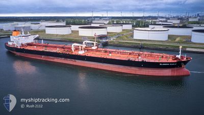
ELANDRA EAGLE
Not available
Current Trip
| Time Travelled | 3 days |
|---|---|
| Remaining Time | --- |
| Distance Travelled | 981.74 nm |
| Remaining Distance | --- |
| AVG Speed | 11.8 Knots |
| MAX Speed | 14.3 Knots |
| AVG Wind | 15 knots |
| MAX Wind | 22 knots |
| MIN Temp | 18.1°C / 64.58°F |
| MAX Temp | 25.8°C / 78.44°F |
| Draught | 13.7 m |
| Position Received | 3 d ago |
Current Position
| Longitude | -94.78563° |
|---|---|
| Latitude | 29.35174° |
| Status | Under way using engine |
| Speed | 9.4 Knots |
| Course | 139.4° |
| Area | Gulf of Mexico |
| Station | T-AIS |
| Position Received | 3 d ago |
Info
Information
The current position of ELANDRA EAGLE is in Gulf of Mexico with coordinates 29.35174° / -94.78563° as reported on 2024-04-22 02:14 by AIS to our vessel tracker app. The vessel's current speed is 9.4 Knots and is heading at the port of ROTTERDAM. The estimated time of arrival as calculated by MyShipTracking vessel tracking app is 2024-05-08 21:00 LT
The vessel ELANDRA EAGLE (IMO: 9792474, MMSI: 538007153) is a Not available It's sailing under the flag of [MH] Marshall Is.
In this page you can find informations about the vessels current position, last detected port calls, and current voyage information. If the vessels is not in coverage by AIS you will find the latest position.
The current position of ELANDRA EAGLE is detected by our AIS receivers and we are not responsible for the reliability of the data. The last position was recorded while the vessel was in Coverage by the Ais receivers of our vessel tracking app.
The current draught of ELANDRA EAGLE as reported by AIS is 13.7 meters
Weather
| Temperature | 23.1°C / 73.58°F |
|---|---|
| Wind Speed | 8 knots |
| Direction | 68° ENE |
| Pressure | 1018.7 hPa |
| Humidity | 62.3 % |
| Cloud Coverage | 4 % |
Featured Company
Last Port Calls
| Port | Arrival | Departure | Time In Port |
|---|---|---|---|
| 2024-04-19 15:40 | 2024-04-22 00:20 | 2 d | |
| 2024-04-12 23:07 | 2024-04-14 20:46 | 1 d | |
| 2024-03-18 12:55 | 2024-03-18 14:21 | 1 h | |
| 2024-03-13 18:52 | 2024-03-15 14:08 | 1 d |
Last Trips
| Origin | Departure | Destination | Arrival | Distance | |
|---|---|---|---|---|---|
| 2024-04-14 15:46 | 2024-04-19 10:40 | 163.46 nm | |||
| 2024-03-18 09:21 | 2024-04-12 18:07 | 4926.54 nm | |||
| 2024-03-15 09:08 | 2024-03-18 07:55 | 129.23 nm | |||
| 2024-01-31 09:34 | 2024-03-13 13:52 | 8241.43 nm |
Events
| Time | Event | Details | Position / Dest | Info |
|---|---|---|---|---|
| 2024-04-22 02:23 | Status Changed | Default Under way using engine |
29.34276 / -94.76203
NL RTM
|
Speed: 9.4 kn Course: 139.4° |
| 2024-04-22 02:14 | OUT of Coverage |
29.35174 / -94.78563
Gulf of Mexico
NL RTM
|
Speed: 9.4 kn Course: 139.4° |
|
| 2024-04-22 02:05 | Status Changed | Under way using engine Default |
29.36859 / -94.80286
NL RTM
|
Speed: 9.5 kn Course: 156° |
| 2024-04-22 01:44 | Status Changed | Default Under way using engine |
29.41816 / -94.82733
NL RTM
|
Speed: 9.3 kn Course: 156.3° |
| 2024-04-22 01:32 | ETA Changed | 2024/05/08 21:00 2024/05/08 21:07 |
29.44820 / -94.84242
NL RTM
|
Speed: 9.3 kn Course: 155.5° |
| 2024-04-22 01:28 | Status Changed | Under way using engine Default |
29.45758 / -94.84708
NL RTM
|
Speed: 9.1 kn Course: 156° |
| 2024-04-22 01:22 | Status Changed | Default Under way using engine |
29.46981 / -94.85333
NL RTM
|
Speed: 7.6 kn Course: 155.3° |
| 2024-04-22 00:50 | ETA Changed | 2024/05/08 21:07 |
29.53297 / -94.89542
NL RTM
|
Speed: 9.1 kn Course: 147.8° |
| 2024-04-22 00:20 | PORT DEPARTURE |
|
29.59060 / -94.93990
NL RTM
|
Speed: 8 kn Course: 146° |
| 2024-04-21 22:44 | Draught Changed | 13.7 9.5 |
29.73783 / -95.05724
[US] HOUSTON
|
Speed: 6 kn Course: 130° |