
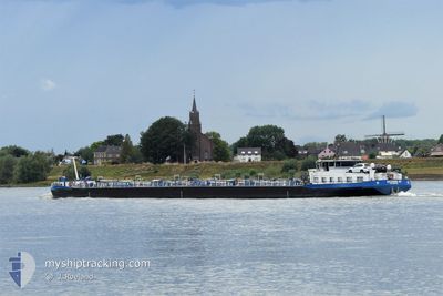
EILTANK 69
Tanker
Current Trip
| Time Travelled | 18 h, 54 mins |
|---|---|
| Remaining Time | 16 h, 19 mins |
| Distance Travelled | 165.11 nm |
| Remaining Distance | 171.59 nm |
| AVG Speed | 10.4 Knots |
| MAX Speed | 11.8 Knots |
| AVG Wind | 10 knots |
| MAX Wind | 16.4 knots |
| MIN Temp | 4°C / 39.2°F |
| MAX Temp | 8.1°C / 46.58°F |
| Draught | 1.7 m |
| Position Received | 1 m ago |
Current Position
| Longitude | 6.95396° |
|---|---|
| Latitude | 51.03730° |
| Status | Under way using engine |
| Speed | 11 Knots |
| Course | 308.2° |
| Area | North Sea |
| Station | T-AIS |
| Position Received | 1 m ago |
Info
Information
The current position of EILTANK 69 is in North Sea with coordinates 51.03730° / 6.95396° as reported on 2024-04-19 16:21 by AIS to our vessel tracker app. The vessel's current speed is 11 Knots and is heading at the port of ROTTERDAM. The estimated time of arrival as calculated by MyShipTracking vessel tracking app is 2024-04-20 08:41 LT
The vessel EILTANK 69 (MMSI: 211555440) is a Tanker It's sailing under the flag of [DE] Germany.
In this page you can find informations about the vessels current position, last detected port calls, and current voyage information. If the vessels is not in coverage by AIS you will find the latest position.
The current position of EILTANK 69 is detected by our AIS receivers and we are not responsible for the reliability of the data. The last position was recorded while the vessel was in Coverage by the Ais receivers of our vessel tracking app.
The current draught of EILTANK 69 as reported by AIS is 1.7 meters
Weather
| Temperature | 8.2°C / 46.76°F |
|---|---|
| Wind Speed | 13 knots |
| Direction | 311° NW |
| Pressure | 1008.3 hPa |
| Humidity | 82.2 % |
| Cloud Coverage | 99 % |
Featured Company
Last Port Calls
| Port | Arrival | Departure | Time In Port |
|---|---|---|---|
| 2024-04-18 01:34 | 2024-04-18 21:28 | 19 h | |
| 2024-04-15 15:40 | 2024-04-15 16:45 | 1 h | |
| 2024-04-13 22:33 | 2024-04-15 04:31 | 1 d | |
| 2024-04-12 13:50 | 2024-04-13 02:50 | 13 h | |
| 2024-04-10 12:04 | 2024-04-11 19:52 | 1 d | |
| 2024-04-10 01:22 | 2024-04-10 03:51 | 2 h | |
| 2024-04-08 08:40 | 2024-04-08 09:40 | 59 m | |
| 2024-04-07 22:36 | 2024-04-07 23:21 | 44 m | |
| 2024-04-06 22:34 | 2024-04-07 10:36 | 12 h | |
| 2024-04-05 21:51 | 2024-04-06 21:57 | 1 d |
Last Trips
| Origin | Departure | Destination | Arrival | Distance | |
|---|---|---|---|---|---|
| 2024-04-15 18:45 | 2024-04-18 03:34 | 246.72 nm | |||
| 2024-04-15 06:31 | 2024-04-15 17:40 | 77.38 nm | |||
| 2024-04-13 04:50 | 2024-04-14 00:33 | 176.21 nm | |||
| 2024-04-11 21:52 | 2024-04-12 15:50 | 148.76 nm | |||
| 2024-04-10 05:51 | 2024-04-10 14:04 | 28.85 nm | |||
| 2024-04-08 11:40 | 2024-04-10 03:22 | 171.35 nm | |||
| 2024-04-08 01:21 | 2024-04-08 10:40 | 38.80 nm | |||
| 2024-04-07 12:36 | 2024-04-08 00:36 | 77.94 nm | |||
| 2024-04-06 23:57 | 2024-04-07 00:34 | 2.80 nm | |||
| 2024-04-04 19:07 | 2024-04-05 23:51 | 285.43 nm |
Events
| Time | Event | Details | Position / Dest | Info |
|---|---|---|---|---|
| 2024-04-19 12:17 | IN Coverage |
50.50332 / 7.31218
North Sea
ROTTERDAM
|
Speed: 10.9 kn Course: 323.3° |
|
| 2024-04-19 07:35 | OUT of Coverage |
49.97291 / 7.91088
North Sea
ROTTERDAM
|
Speed: 9.2 kn Course: 263.4° |
|
| 2024-04-19 07:32 | START Moving | 11.24 nm, West of SCHIERSTEIN |
49.97252 / 7.92133
ROTTERDAM
|
Speed: 8.7 kn Course: 279.8° |
| 2024-04-19 07:25 | Status Changed | Under way using engine Moored |
49.97116 / 7.92692
ROTTERDAM
|
Speed: Course: 96° |
| 2024-04-19 06:15 | Status Changed | Moored Under way using engine |
49.97109 / 7.92667
ROTTERDAM
|
Speed: Course: 97° |
| 2024-04-19 05:58 | STOP Moving | 11.08 nm, West of SCHIERSTEIN |
49.97108 / 7.92664
ROTTERDAM
|
Speed: 0.3 kn Course: 96° |
| 2024-04-19 04:45 | Draught Changed | 1.7 2.7 |
50.02933 / 8.15666
ROTTERDAM
|
Speed: 9.1 kn Course: 240.6° |
| 2024-04-19 04:45 | Destination Changed | ROTTERDAM KARLSRUHE |
50.02933 / 8.15666
ROTTERDAM
|
Speed: 9.1 kn Course: 240.6° |
| 2024-04-19 04:45 | ETA Changed | 2024/04/20 09:00 2024/04/17 20:00 |
50.02933 / 8.15666
ROTTERDAM
|
Speed: 9.1 kn Course: 240.6° |
| 2024-04-19 01:54 | IN Coverage |
49.71554 / 8.42193
North Sea
|
Speed: 10.2 kn Course: 75.1° |