
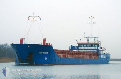
EEMS STREAM
General Cargo
Current Trip
| Time Travelled | 7 days |
|---|---|
| Remaining Time | --- |
| Distance Travelled | 1435.49 nm |
| Remaining Distance | --- |
| AVG Speed | 8.8 Knots |
| MAX Speed | 11.4 Knots |
| AVG Wind | 7.2 knots |
| MAX Wind | 27 knots |
| MIN Temp | 12.2°C / 53.96°F |
| MAX Temp | 24°C / 75.2°F |
| Draught | 4.5 m |
| Position Received | 1 m ago |
Current Position
| Longitude | 29.08342° |
|---|---|
| Latitude | 40.80135° |
| Status | Under way using engine |
| Speed | 0.4 Knots |
| Course | 161° |
| Area | Sea of Marmara |
| Station | T-AIS |
| Position Received | 1 m ago |
Info
Information
The current position of EEMS STREAM is in Sea of Marmara with coordinates 40.80135° / 29.08342° as reported on 2024-04-19 05:50 by AIS to our vessel tracker app. The vessel's current speed is 0.4 Knots
The vessel EEMS STREAM (IMO: 9559638, MMSI: 245926000) is a General Cargo that was built in 2010 ( 14 years old ). It's sailing under the flag of [NL] Netherlands.
In this page you can find informations about the vessels current position, last detected port calls, and current voyage information. If the vessels is not in coverage by AIS you will find the latest position.
The current position of EEMS STREAM is detected by our AIS receivers and we are not responsible for the reliability of the data. The last position was recorded while the vessel was in Coverage by the Ais receivers of our vessel tracking app.
The current draught of EEMS STREAM as reported by AIS is 4.5 meters
Weather
| Temperature | 12.8°C / 55.04°F |
|---|---|
| Wind Speed | 8 knots |
| Direction | 76° ENE |
| Pressure | 1012 hPa |
| Humidity | 89.5 % |
| Cloud Coverage | 98 % |
Featured Company
Last Port Calls
| Port | Arrival | Departure | Time In Port |
|---|---|---|---|
| 2024-04-11 21:02 | 2024-04-11 21:38 | 36 m | |
| 2024-04-10 10:30 | 2024-04-10 11:15 | 45 m | |
| 2024-04-07 10:13 | 2024-04-08 16:11 | 1 d | |
| 2024-03-20 00:59 | 2024-03-22 13:59 | 2 d | |
| 2024-03-10 09:08 | 2024-03-13 16:44 | 3 d | |
| 2024-02-29 08:12 | 2024-03-01 19:21 | 1 d | |
| 2024-02-14 18:42 | 2024-02-15 19:15 | 1 d | |
| 2024-02-09 15:03 | 2024-02-14 05:15 | 4 d | |
| 2024-02-03 11:52 |
Most Visited Ports (Last year)
| Port | Arrivals | |
|---|---|---|
| 14 | ||
| 11 | ||
| 5 | ||
| 4 | ||
| 2 | ||
| 2 |
Last Trips
| Origin | Departure | Destination | Arrival | Distance | |
|---|---|---|---|---|---|
| 2024-04-10 13:15 | 2024-04-11 23:02 | 49.67 nm | |||
| 2024-04-08 18:11 | 2024-04-10 12:30 | 277.01 nm | |||
| 2024-03-22 14:59 | 2024-04-07 12:13 | 1956.72 nm | |||
| 2024-03-13 17:44 | 2024-03-20 01:59 | 1220.12 nm | |||
| 2024-03-01 20:21 | 2024-03-10 10:08 | 1485.63 nm | |||
| 2024-02-15 20:15 | 2024-02-29 09:12 | 2700.40 nm | |||
| 2024-02-14 06:15 | 2024-02-14 19:42 | 26.56 nm | |||
| 2024-02-03 12:52 | 2024-02-09 16:03 | 1214.36 nm |
Events
| Time | Event | Details | Position / Dest | Info |
|---|---|---|---|---|
| 2024-04-18 17:24 | STOP Moving | 7.84 nm, South West of KARTAL |
40.78048 / 29.09476
TRHER
|
Speed: 0.3 kn Course: 140° |
| 2024-04-18 08:59 | IN Coverage |
40.73512 / 28.36731
Sea of Marmara
TRHER
|
Speed: 8.8 kn Course: 89.9° |
|
| 2024-04-18 07:39 | Status Changed | Default Under way using engine |
40.73594 / 28.09160
TRHER
|
Speed: 9.5 kn Course: 80.4° |
| 2024-04-18 07:36 | OUT of Coverage |
40.73482 / 28.08242
Sea of Marmara
TRHER
|
Speed: 9.5 kn Course: 80.4° |
|
| 2024-04-18 03:08 | Status Changed | Under way using engine Default |
40.57555 / 27.21853
TRHER
|
Speed: 8.9 kn Course: 67° |
| 2024-04-18 02:24 | Status Changed | Default Under way using engine |
40.53169 / 27.08720
TRHER
|
Speed: 9 kn Course: 66.3° |
| 2024-04-18 02:23 | Status Changed | Under way using engine Default |
40.53032 / 27.08320
TRHER
|
Speed: 8 kn Course: 65° |
| 2024-04-18 02:07 | IN Coverage |
40.53032 / 27.08320
Sea of Marmara
TRHER
|
Speed: 9 kn Course: 64.9° |
|
| 2024-04-17 23:06 | Status Changed | Default Under way using engine |
40.27167 / 26.55500
TRHER
|
Speed: 9 kn Course: 47.3° |
| 2024-04-17 22:52 | OUT of Coverage |
40.24788 / 26.52079
Sea of Marmara
TRHER
|
Speed: 9 kn Course: 47.3° |