
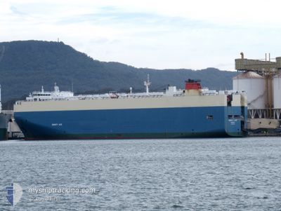
DIGNITY LEADER
Vehicles Carrier
Current Trip
| Time Travelled | 23 days |
|---|---|
| Remaining Time | 2 h, 6 mins |
| Distance Travelled | 7974.31 nm |
| Remaining Distance | 17.45 nm |
| AVG Speed | 14.5 Knots |
| MAX Speed | 19.4 Knots |
| AVG Wind | 14.1 knots |
| MAX Wind | 35.8 knots |
| MIN Temp | 7°C / 44.6°F |
| MAX Temp | 33.1°C / 91.58°F |
| Draught | 9.8 m |
| Position Received | 9 m ago |
Current Position
| Longitude | -119.03174° |
|---|---|
| Latitude | 33.96931° |
| Status | Under way using engine |
| Speed | 7.6 Knots |
| Course | 300.5° |
| Area | North Pacific Ocean |
| Station | T-AIS |
| Position Received | 9 m ago |
Info
Information
The current position of DIGNITY LEADER is in North Pacific Ocean with coordinates 33.96931° / -119.03174° as reported on 2024-04-23 10:22 by AIS to our vessel tracker app. The vessel's current speed is 7.6 Knots and is heading at the port of HUENEME. The estimated time of arrival as calculated by MyShipTracking vessel tracking app is 2024-04-23 12:37 LT
The vessel DIGNITY LEADER (IMO: 9441506, MMSI: 311002900) is a Vehicles Carrier that was built in 2010 ( 14 years old ). It's sailing under the flag of [BS] Bahamas.
In this page you can find informations about the vessels current position, last detected port calls, and current voyage information. If the vessels is not in coverage by AIS you will find the latest position.
The current position of DIGNITY LEADER is detected by our AIS receivers and we are not responsible for the reliability of the data. The last position was recorded while the vessel was in Coverage by the Ais receivers of our vessel tracking app.
The current draught of DIGNITY LEADER as reported by AIS is 9.8 meters
Weather
| Temperature | 13.4°C / 56.12°F |
|---|---|
| Wind Speed | 6 knots |
| Direction | 294° WNW |
| Pressure | 1013.5 hPa |
| Humidity | 86 % |
| Cloud Coverage | 100 % |
Featured Company
Last Port Calls
| Port | Arrival | Departure | Time In Port |
|---|---|---|---|
| 2024-03-30 05:09 | 2024-03-30 23:13 | 18 h | |
| 2024-03-26 23:38 | 2024-03-29 10:22 | 2 d | |
| 2024-03-22 16:24 | 2024-03-23 12:56 | 20 h | |
| 2024-03-19 04:20 | 2024-03-19 14:37 | 10 h | |
| 2024-03-10 19:21 | 2024-03-11 05:27 | 10 h | |
| 2024-03-09 06:08 | 2024-03-09 12:25 | 6 h | |
| 2024-03-05 20:37 | 2024-03-06 14:49 | 18 h | |
| 2024-02-01 08:43 | 2024-02-01 20:04 | 11 h |
Most Visited Ports (Last year)
| Port | Arrivals | |
|---|---|---|
| 3 | ||
| 2 | ||
| 2 | ||
| 2 | ||
| 2 | ||
| 2 |
Last Trips
| Origin | Departure | Destination | Arrival | Distance | |
|---|---|---|---|---|---|
| 2024-03-29 11:22 | 2024-03-30 05:09 | 206.87 nm | |||
| 2024-03-23 12:56 | 2024-03-27 00:38 | 1399.10 nm | |||
| 2024-03-19 15:37 | 2024-03-22 16:24 | 319.87 nm | |||
| 2024-03-11 07:27 | 2024-03-19 05:20 | 1878.41 nm | |||
| 2024-03-09 14:25 | 2024-03-10 21:21 | 379.65 nm | |||
| 2024-03-06 17:49 | 2024-03-09 08:08 | 903.54 nm | |||
| 2024-02-02 04:04 | 2024-03-05 23:37 | 12599.89 nm | |||
| 2024-01-30 16:32 | 2024-02-01 16:43 | 820.07 nm |
Events
| Time | Event | Details | Position / Dest | Info |
|---|---|---|---|---|
| 2024-04-23 10:30 | Status Changed | Default Under way using engine |
33.97868 / -119.05111
US NTD
|
Speed: 7.6 kn Course: 300.5° |
| 2024-04-23 09:45 | Status Changed | Under way using engine Default |
33.92990 / -118.95124
US NTD
|
Speed: 7 kn Course: 299° |
| 2024-04-23 09:41 | Status Changed | Default Under way using engine |
33.92500 / -118.94167
US NTD
|
Speed: 7.6 kn Course: 299.8° |
| 2024-04-23 09:36 | Status Changed | Under way using engine Default |
33.91997 / -118.93040
US NTD
|
Speed: 7.6 kn Course: 300° |
| 2024-04-23 09:30 | Status Changed | Default Under way using engine |
33.91435 / -118.91854
US NTD
|
Speed: 7.6 kn Course: 296.4° |
| 2024-04-23 09:22 | Status Changed | Under way using engine Default |
33.90551 / -118.89907
US NTD
|
Speed: 7.6 kn Course: 296° |
| 2024-04-23 09:18 | Status Changed | Default Under way using engine |
33.90247 / -118.89172
US NTD
|
Speed: 7.5 kn Course: 296.7° |
| 2024-04-23 05:32 | Status Changed | Under way using engine Default |
33.66249 / -118.39507
US NTD
|
Speed: 7.5 kn Course: 300° |
| 2024-04-23 05:22 | Status Changed | Default Under way using engine |
33.65240 / -118.37452
US NTD
|
Speed: 7.5 kn Course: 298.7° |
| 2024-04-22 19:29 | Change Sea Area | United States part of the North Pacific Ocean Mexican part of the North Pacific Ocean |
32.61337 / -117.65053
North Pacific Ocean
US NTD
|
Speed: 9.1 kn Course: 335.5° |