
DAMSGAARD
Tanker B
Current Trip
| Time Travelled | 3 h, 26 mins |
|---|---|
| Remaining Time | --- |
| Distance Travelled | 33.84 nm |
| Remaining Distance | --- |
| AVG Speed | 11.4 Knots |
| MAX Speed | 11.9 Knots |
| AVG Wind | 14.9 knots |
| MAX Wind | 17.3 knots |
| MIN Temp | 25.3°C / 77.54°F |
| MAX Temp | 25.8°C / 78.44°F |
| Draught | 7 m |
| Position Received | 8 d ago |
Current Position
| Longitude | 129.20711° |
|---|---|
| Latitude | 34.78964° |
| Status | Under way using engine |
| Speed | 11.3 Knots |
| Course | 191° |
| Area | Japan Sea |
| Station | T-AIS |
| Position Received | 8 d ago |
Info
Information
The current position of DAMSGAARD is in Japan Sea with coordinates 34.78964° / 129.20711° as reported on 2024-04-15 03:01 by AIS to our vessel tracker app. The vessel's current speed is 11.3 Knots and is heading at the port of YEOSU. The estimated time of arrival as calculated by MyShipTracking vessel tracking app is 2024-04-15 16:00 LT
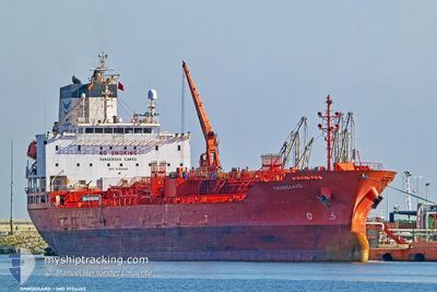
The vessel DAMSGAARD (IMO: 9724453, MMSI: 257087000) is a Tanker B It's sailing under the flag of [NO] Norway.
In this page you can find informations about the vessels current position, last detected port calls, and current voyage information. If the vessels is not in coverage by AIS you will find the latest position.
The current position of DAMSGAARD is detected by our AIS receivers and we are not responsible for the reliability of the data. The last position was recorded while the vessel was in Coverage by the Ais receivers of our vessel tracking app.
The current draught of DAMSGAARD as reported by AIS is 7 meters
Weather
| Temperature | 25.3°C / 77.54°F |
|---|---|
| Wind Speed | 13 knots |
| Direction | 234° SW |
| Pressure | 1010.5 hPa |
| Humidity | 87 % |
| Cloud Coverage | 100 % |
Featured Company
Last Port Calls
| Port | Arrival | Departure | Time In Port |
|---|---|---|---|
| 2024-04-23 01:59 | 2024-04-23 12:12 | 10 h | |
| 2024-04-20 02:20 | |||
| 2024-04-14 17:23 | 2024-04-14 23:36 | 6 h | |
| 2024-04-13 22:27 | 2024-04-14 16:28 | 18 h | |
| 2024-04-13 10:52 | 2024-04-13 21:45 | 10 h | |
| 2024-03-17 21:29 | |||
| 2024-03-14 10:08 | 2024-03-17 02:33 | 2 d | |
| 2024-02-11 13:23 | 2024-02-13 04:26 | 1 d |
Last Trips
| Origin | Departure | Destination | Arrival | Distance | |
|---|---|---|---|---|---|
| 2024-04-20 11:20 | 2024-04-23 09:59 | 825.67 nm | |||
| 2024-04-15 01:28 | 2024-04-15 02:23 | 9.06 nm | |||
| 2024-04-14 06:45 | 2024-04-14 07:27 | 4.98 nm | |||
| 2024-04-14 06:45 | 2024-04-13 19:52 | 4.98 nm | |||
| 2024-03-17 05:33 | 2024-03-18 00:29 | 6.92 nm | |||
| 2024-02-13 09:56 | 2024-03-14 13:08 | 2897.81 nm | |||
| 2023-12-24 11:49 | 2024-02-11 18:53 | 9358.24 nm |
Events
| Time | Event | Details | Position / Dest | Info |
|---|---|---|---|---|
| 2024-04-23 12:12 | PORT DEPARTURE |
|
24.29468 / 120.49001
YEOSU,KOREA
|
Speed: 7.5 kn Course: 286° |
| 2024-04-23 11:52 | START Moving |
24.27475 / 120.51089
[TW] TAICHUNG
|
Speed: 4.2 kn Course: 49° |
|
| 2024-04-23 02:31 | STOP Moving |
24.27189 / 120.50743
[TW] TAICHUNG
|
Speed: 0.3 kn Course: 22° |
|
| 2024-04-23 01:59 | PORT ARRIVAL |
|
24.29185 / 120.50241
[TW] TAICHUNG
|
Speed: 7.2 kn Course: 89° |
| 2024-04-20 02:20 | PORT DEPARTURE |
|
34.86319 / 127.77751
YEOSU,KOREA
|
Speed: 4.2 kn Course: 112° |
| 2024-04-20 02:15 | START Moving |
34.86768 / 127.76762
[KR] GWANGYANG
|
Speed: 4.2 kn Course: 112° |
|
| 2024-04-17 10:32 | STOP Moving | 4.54 nm, South East of GWANGYANG |
34.87142 / 127.78387
YEOSU,KOREA
|
Speed: 0.2 kn Course: 314° |
| 2024-04-17 09:16 | START Moving | 6.43 nm, East of YEOSU |
34.72713 / 127.79417
YEOSU,KOREA
|
Speed: 3.4 kn Course: 120° |
| 2024-04-15 15:23 | STOP Moving | 6.34 nm, East of YEOSU |
34.72833 / 127.79251
YEOSU,KOREA
|
Speed: 0.2 kn Course: 92° |
| 2024-04-15 03:01 | OUT of Coverage |
34.78964 / 129.20711
Japan Sea
YEOSU,KOREA
|
Speed: 11.3 kn Course: 191° |