
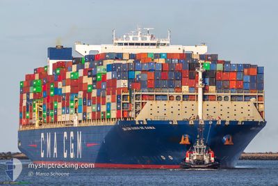
CMACGM VASCO DE GAMA
Cargo A
Current Trip
| Time Travelled | 13 days |
|---|---|
| Remaining Time | --- |
| Distance Travelled | 6003.52 nm |
| Remaining Distance | --- |
| AVG Speed | 18.5 Knots |
| MAX Speed | 23 Knots |
| AVG Wind | 11.3 knots |
| MAX Wind | 26.5 knots |
| MIN Temp | 14.3°C / 57.74°F |
| MAX Temp | 31.6°C / 88.88°F |
| Draught | 15.6 m |
| Position Received | 19 h, 1 m ago |
Current Position
| Longitude | 17.66957° |
|---|---|
| Latitude | -34.13343° |
| Status | Under way using engine |
| Speed | 18.5 Knots |
| Course | 311.5° |
| Area | South Atlantic Ocean |
| Station | T-AIS |
| Position Received | 19 h, 1 m ago |
Info
Information
The current position of CMACGM VASCO DE GAMA is in South Atlantic Ocean with coordinates -34.13343° / 17.66957° as reported on 2024-04-23 05:41 by AIS to our vessel tracker app. The vessel's current speed is 18.5 Knots and is heading at the port of LE HAVRE. The estimated time of arrival as calculated by MyShipTracking vessel tracking app is 2024-05-06 10:00 LT
The vessel CMACGM VASCO DE GAMA (IMO: 9706889, MMSI: 215173000) is a Cargo A It's sailing under the flag of [MT] Malta.
In this page you can find informations about the vessels current position, last detected port calls, and current voyage information. If the vessels is not in coverage by AIS you will find the latest position.
The current position of CMACGM VASCO DE GAMA is detected by our AIS receivers and we are not responsible for the reliability of the data. The last position was recorded while the vessel was in Coverage by the Ais receivers of our vessel tracking app.
The current draught of CMACGM VASCO DE GAMA as reported by AIS is 15.6 meters
Weather
| Temperature | 20.2°C / 68.36°F |
|---|---|
| Wind Speed | 11 knots |
| Direction | 181° S |
| Pressure | 1018.1 hPa |
| Humidity | 72.6 % |
| Cloud Coverage | 100 % |
Featured Company
Last Port Calls
| Port | Arrival | Departure | Time In Port |
|---|---|---|---|
| 2024-04-09 17:04 | 2024-04-10 18:04 | 1 d | |
| 2024-04-03 01:53 | 2024-04-04 13:45 | 1 d | |
| 2024-03-29 10:41 | 2024-03-30 20:17 | 1 d | |
| 2024-03-21 11:58 | 2024-03-23 07:43 | 1 d | |
| 2024-03-13 09:14 | 2024-03-15 11:03 | 2 d | |
| 2024-02-11 21:39 | 2024-02-13 14:37 | 1 d | |
| 2024-02-05 17:39 | 2024-02-06 21:33 | 1 d |
Most Visited Ports (Last year)
| Port | Arrivals | |
|---|---|---|
| 7 | ||
| 7 | ||
| 4 | ||
| 4 | ||
| 4 | ||
| 4 |
Last Trips
| Origin | Departure | Destination | Arrival | Distance | |
|---|---|---|---|---|---|
| 2024-04-04 21:45 | 2024-04-10 01:04 | 1500.24 nm | |||
| 2024-03-31 04:17 | 2024-04-03 09:53 | 822.23 nm | |||
| 2024-03-23 16:43 | 2024-03-29 18:41 | 691.49 nm | |||
| 2024-03-15 19:03 | 2024-03-21 20:58 | 2710.26 nm | |||
| 2024-02-13 15:37 | 2024-03-13 17:14 | 11710.54 nm | |||
| 2024-02-06 22:33 | 2024-02-11 22:39 | 1073.49 nm | |||
| 2024-01-31 02:21 | 2024-02-05 18:39 | 1232.06 nm |
Events
| Time | Event | Details | Position / Dest | Info |
|---|---|---|---|---|
| 2024-04-23 05:47 | Status Changed | Default Under way using engine |
-34.11483 / 17.64625
FRLEH
|
Speed: 18.5 kn Course: 311.5° |
| 2024-04-23 05:41 | OUT of Coverage |
-34.13343 / 17.66957
South Atlantic Ocean
FRLEH
|
Speed: 18.5 kn Course: 311.5° |
|
| 2024-04-23 03:05 | Draught Changed | 15.6 15.9 |
-34.60077 / 18.50700
FRLEH
|
Speed: 19 kn Course: 275.5° |
| 2024-04-23 02:27 | Status Changed | Under way using engine Default |
-34.64348 / 18.74060
FRLEH
|
Speed: 18.9 kn Course: 288° |
| 2024-04-23 01:58 | Status Changed | Default Under way using engine |
-34.69223 / 18.91387
FRLEH
|
Speed: 18.6 kn Course: 289.5° |
| 2024-04-23 00:32 | Change Sea Area | South African part of the South Atlantic Ocean Malaysian part of the Malacca Strait |
-34.86180 / 19.42690
South Atlantic Ocean
FRLEH
|
Speed: 18.9 kn Course: 291.1° |
| 2024-04-23 00:31 | Status Changed | Under way using engine Default |
-34.86332 / 19.43167
FRLEH
|
Speed: 18.8 kn Course: 291° |
| 2024-04-23 00:31 | IN Coverage |
-34.86180 / 19.42690
South Atlantic Ocean
FRLEH
|
Speed: 18.9 kn Course: 291.1° |