
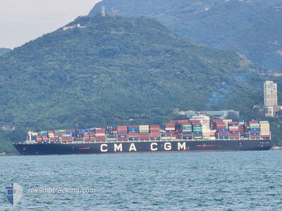
CMA CGM COCHIN
Cargo A
Current Trip
| Time Travelled | 1 day |
|---|---|
| Remaining Time | --- |
| Distance Travelled | 870.62 nm |
| Remaining Distance | --- |
| AVG Speed | 17.6 Knots |
| MAX Speed | 23.2 Knots |
| AVG Wind | 13.4 knots |
| MAX Wind | 31.5 knots |
| MIN Temp | 5.4°C / 41.72°F |
| MAX Temp | 16.5°C / 61.7°F |
| Draught | 14.6 m |
| Position Received | 6 h, 51 m ago |
Current Position
| Longitude | 141.60378° |
|---|---|
| Latitude | 41.70399° |
| Status | Under way using engine |
| Speed | 20.5 Knots |
| Course | 81.7° |
| Area | North Pacific Ocean |
| Station | T-AIS |
| Position Received | 6 h, 51 m ago |
Info
Information
The current position of CMA CGM COCHIN is in North Pacific Ocean with coordinates 41.70399° / 141.60378° as reported on 2024-04-19 14:22 by AIS to our vessel tracker app. The vessel's current speed is 20.5 Knots and is heading at the port of SEATTLE. The estimated time of arrival as calculated by MyShipTracking vessel tracking app is 2024-04-28 07:00 LT
The vessel CMA CGM COCHIN (IMO: 9768007, MMSI: 477166700) is a Cargo A It's sailing under the flag of [HK] Hong Kong.
In this page you can find informations about the vessels current position, last detected port calls, and current voyage information. If the vessels is not in coverage by AIS you will find the latest position.
The current position of CMA CGM COCHIN is detected by our AIS receivers and we are not responsible for the reliability of the data. The last position was recorded while the vessel was in Coverage by the Ais receivers of our vessel tracking app.
The current draught of CMA CGM COCHIN as reported by AIS is 14.6 meters
Weather
| Temperature | 6.9°C / 44.42°F |
|---|---|
| Wind Speed | 27 knots |
| Direction | 336° NNW |
| Pressure | 1000.9 hPa |
| Humidity | 79 % |
| Cloud Coverage | 100 % |
Featured Company
Last Port Calls
| Port | Arrival | Departure | Time In Port |
|---|---|---|---|
| 2024-04-16 18:39 | 2024-04-17 22:53 | 1 d | |
| 2024-04-15 00:45 | 2024-04-15 01:14 | 29 m | |
| 2024-04-15 00:24 | 2024-04-15 00:41 | 17 m | |
| 2024-04-14 21:03 | 2024-04-15 00:17 | 3 h | |
| 2024-04-14 19:21 | 2024-04-14 20:59 | 1 h | |
| 2024-04-14 18:33 | 2024-04-14 19:17 | 44 m | |
| 2024-04-14 18:09 | 2024-04-14 18:29 | 20 m | |
| 2024-04-14 17:33 | 2024-04-14 18:05 | 32 m | |
| 2024-04-14 15:09 | 2024-04-14 17:29 | 2 h | |
| 2024-04-14 14:33 | 2024-04-14 15:05 | 32 m |
Last Trips
| Origin | Departure | Destination | Arrival | Distance | |
|---|---|---|---|---|---|
| 2024-04-15 09:14 | 2024-04-17 03:39 | 480.20 nm | |||
| 2024-04-15 08:41 | 2024-04-15 08:45 | 0.12 nm | |||
| 2024-04-15 08:17 | 2024-04-15 08:24 | 0.12 nm | |||
| 2024-04-15 04:59 | 2024-04-15 05:03 | 0.11 nm | |||
| 2024-04-15 03:17 | 2024-04-15 03:21 | 0.12 nm | |||
| 2024-04-15 02:29 | 2024-04-15 02:33 | 0.12 nm | |||
| 2024-04-15 02:05 | 2024-04-15 02:09 | 0.12 nm | |||
| 2024-04-15 01:29 | 2024-04-15 01:33 | 0.11 nm | |||
| 2024-04-14 23:05 | 2024-04-14 23:09 | 0.12 nm | |||
| 2024-04-14 22:29 | 2024-04-14 22:33 | 0.12 nm |
Events
| Time | Event | Details | Position / Dest | Info |
|---|---|---|---|---|
| 2024-04-19 14:22 | OUT of Coverage |
41.70399 / 141.60378
North Pacific Ocean
USSEA
|
Speed: 20.5 kn Course: 81.7° |
|
| 2024-04-19 13:38 | Change Sea Area | Japanese part of the North Pacific Ocean Japanese part of the Japan Sea |
41.67544 / 141.27369
North Pacific Ocean
USSEA
|
Speed: 19.6 kn Course: 90.3° |
| 2024-04-19 10:01 | Change Sea Area | Japanese part of the Japan Sea South Korean part of the Japan Sea |
41.03498 / 139.88431
Japan Sea
USSEA
|
Speed: 18.7 kn Course: 47.2° |
| 2024-04-19 10:01 | IN Coverage |
41.03498 / 139.88431
Japan Sea
USSEA
|
Speed: 18.7 kn Course: 47.2° |
|
| 2024-04-18 05:21 | OUT of Coverage |
35.63737 / 130.55972
Japan Sea
USSEA
|
Speed: 18.9 kn Course: 54.1° |
|
| 2024-04-18 05:21 | Status Changed | Under way using engine Default |
35.63672 / 130.55860
USSEA
|
Speed: 19.1 kn Course: 57° |
| 2024-04-18 05:21 | IN Coverage |
35.63737 / 130.55972
Japan Sea
USSEA
|
Speed: 18.9 kn Course: 54.1° |
|
| 2024-04-18 04:25 | Status Changed | Default Under way using engine |
35.46783 / 130.25363
USSEA
|
Speed: 19.2 kn Course: 56.1° |
| 2024-04-18 04:20 | Status Changed | Under way using engine Default |
35.45343 / 130.22684
USSEA
|
Speed: 19.2 kn Course: 54° |
| 2024-04-18 04:20 | OUT of Coverage |
35.45343 / 130.22684
Japan Sea
USSEA
|
Speed: 19.2 kn Course: 56.1° |