
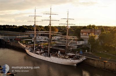
CHRISTIAN RADICH
Sailing Vessel
Current Trip
DK HVS>SE MSD
| Time Travelled | 4 days |
|---|---|
| Remaining Time | --- |
| Distance Travelled | 353.08 nm |
| Remaining Distance | --- |
| AVG Speed | 5.4 Knots |
| MAX Speed | 8.1 Knots |
| AVG Wind | 15.6 knots |
| MAX Wind | 29.2 knots |
| MIN Temp | 2°C / 35.6°F |
| MAX Temp | 7.5°C / 45.5°F |
| Draught | 4.7 m |
| Position Received | 3 m ago |
Current Position
| Longitude | 11.59076° |
|---|---|
| Latitude | 57.88321° |
| Status | At anchor |
| Speed | |
| Course | 60° |
| Area | Kattegat |
| Station | T-AIS |
| Position Received | 3 m ago |
Info
Information
The current position of CHRISTIAN RADICH is in Kattegat with coordinates 57.88321° / 11.59076° as reported on 2024-04-24 01:53 by AIS to our vessel tracker app. The vessel's current speed is 0 Knots
The vessel CHRISTIAN RADICH (IMO: 5071729, MMSI: 258373000) is a Sailing Vessel that was built in 1937 ( 87 years old ). It's sailing under the flag of [NO] Norway.
In this page you can find informations about the vessels current position, last detected port calls, and current voyage information. If the vessels is not in coverage by AIS you will find the latest position.
The current position of CHRISTIAN RADICH is detected by our AIS receivers and we are not responsible for the reliability of the data. The last position was recorded while the vessel was in Coverage by the Ais receivers of our vessel tracking app.
The current draught of CHRISTIAN RADICH as reported by AIS is 4.7 meters
Weather
| Temperature | 4.4°C / 39.92°F |
|---|---|
| Wind Speed | 8 knots |
| Direction | 119° ESE |
| Pressure | 1010.5 hPa |
| Humidity | 79.4 % |
| Cloud Coverage | 75 % |
Featured Company
Last Port Calls
| Port | Arrival | Departure | Time In Port |
|---|---|---|---|
| 2024-04-17 12:03 | 2024-04-19 08:34 | 1 d | |
| 2024-04-06 16:36 | 2024-04-08 11:56 | 1 d | |
| 2024-03-27 07:41 | 2024-04-03 11:25 | 7 d | |
| 2024-03-07 12:57 | 2024-03-10 09:13 | 2 d | |
| 2024-02-28 09:29 | 2024-03-05 08:34 | 5 d | |
| 2024-02-19 07:51 | 2024-02-21 14:37 | 2 d | |
| 2024-02-04 13:57 |
Last Trips
| Origin | Departure | Destination | Arrival | Distance | |
|---|---|---|---|---|---|
| 2024-04-08 13:56 | 2024-04-17 14:03 | 386.19 nm | |||
| 2024-04-03 13:25 | 2024-04-06 18:36 | 176.08 nm | |||
| 2024-03-10 10:13 | 2024-03-27 08:41 | 1719.24 nm | |||
| 2024-03-05 08:34 | 2024-03-07 13:57 | 351.56 nm | |||
| 2024-02-21 15:37 | 2024-02-28 09:29 | 280.74 nm | |||
| 2024-02-04 13:57 | 2024-02-19 08:51 | 948.94 nm |
Events
| Time | Event | Details | Position / Dest | Info |
|---|---|---|---|---|
| 2024-04-22 12:43 | ETA Changed | 2024/04/22 13:13 2024/04/22 13:09 |
57.88225 / 11.59020
DK HVS>SE MSD
|
Speed: 0.1 kn Course: 30° |
| 2024-04-22 12:42 | Status Changed | At anchor Under way using engine |
57.88229 / 11.59021
DK HVS>SE MSD
|
Speed: 0.3 kn Course: 31° |
| 2024-04-22 12:39 | STOP Moving | 3.49 nm, South of STANSVIKS |
57.88255 / 11.59042
DK HVS>SE MSD
|
Speed: 0.3 kn Course: 18° |
| 2024-04-22 11:08 | Change Sea Area | Swedish part of the Kattegat Swedish part of the Skaggerak |
57.88592 / 11.35813
Kattegat
DK HVS>SE MSD
|
Speed: 5 kn Course: 90.9° |
| 2024-04-22 08:44 | Detected in Sea | Swedish part of the Skaggerak |
57.90877 / 10.90684
Skaggerak
DK HVS>SE MSD
|
Speed: 6.6 kn Course: 95.5° |
| 2024-04-22 07:26 | ETA Changed | 2024/04/22 13:09 2024/04/22 09:09 |
57.92857 / 10.65132
DK HVS>SE MSD
|
Speed: 6.1 kn Course: 98.2° |
| 2024-04-22 01:14 | Detected in Sea | Danish part of the Skaggerak |
58.02148 / 9.46770
Skaggerak
DK HVS>SE MSD
|
Speed: 5.7 kn Course: 93.6° |
| 2024-04-21 22:29 | START Moving |
58.04478 / 8.99362
DK HVS>SE MSD
|
Speed: 4 kn Course: 96° |
|
| 2024-04-21 22:25 | Status Changed | Under way using engine Under way sailing |
58.04571 / 8.98832
DK HVS>SE MSD
|
Speed: 0.3 kn Course: 137° |
| 2024-04-21 16:40 | STOP Moving | 16.58 nm, South East of GRIMSTAD |
58.08912 / 8.82190
DK HVS>SE MSD
|
Speed: 0.3 kn Course: 327° |