
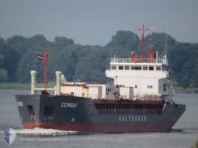
CEMBAY
Cement Carrier
Current Trip
| Time Travelled | 2 days |
|---|---|
| Remaining Time | 19 h, 4 mins |
| Distance Travelled | 231.06 nm |
| Remaining Distance | 223.26 nm |
| AVG Speed | 8.9 Knots |
| MAX Speed | 11.6 Knots |
| AVG Wind | 8.7 knots |
| MAX Wind | 13.3 knots |
| MIN Temp | 7.2°C / 44.96°F |
| MAX Temp | 11.3°C / 52.34°F |
| Draught | 4.3 m |
| Position Received | 1 h, 7 m ago |
Current Position
| Longitude | -5.20461° |
|---|---|
| Latitude | 46.99835° |
| Status | Under way using engine |
| Speed | 10.6 Knots |
| Course | 162.8° |
| Area | Celtic Sea |
| Station | T-AIS |
| Position Received | 1 h, 7 m ago |
Info
Information
The current position of CEMBAY is in Celtic Sea with coordinates 46.99835° / -5.20461° as reported on 2024-04-19 10:46 by AIS to our vessel tracker app. The vessel's current speed is 10.6 Knots and is heading at the port of SANTANDER. The estimated time of arrival as calculated by MyShipTracking vessel tracking app is 2024-04-20 06:57 LT
The vessel CEMBAY (IMO: 9183465, MMSI: 212542000) is a Cement Carrier that was built in 1997 ( 27 years old ). It's sailing under the flag of [CY] Cyprus.
In this page you can find informations about the vessels current position, last detected port calls, and current voyage information. If the vessels is not in coverage by AIS you will find the latest position.
The current position of CEMBAY is detected by our AIS receivers and we are not responsible for the reliability of the data. The last position was recorded while the vessel was in Coverage by the Ais receivers of our vessel tracking app.
The current draught of CEMBAY as reported by AIS is 4.3 meters
Weather
| Temperature | 11.2°C / 52.16°F |
|---|---|
| Wind Speed | 4 knots |
| Direction | 337° NNW |
| Pressure | 1024.8 hPa |
| Humidity | 59.5 % |
| Cloud Coverage | 12 % |
Featured Company
Last Port Calls
| Port | Arrival | Departure | Time In Port |
|---|---|---|---|
| 2024-04-16 21:43 | 2024-04-16 21:49 | 5 m | |
| 2024-04-13 04:12 | 2024-04-14 08:29 | 1 d | |
| 2024-04-09 20:43 | 2024-04-09 21:25 | 41 m | |
| 2024-04-09 20:02 | 2024-04-09 20:22 | 20 m | |
| 2024-04-07 01:04 | 2024-04-09 19:17 | 2 d | |
| 2024-04-06 23:31 | 2024-04-06 23:51 | 20 m | |
| 2024-04-06 22:29 | 2024-04-06 23:08 | 39 m | |
| 2024-04-01 23:47 | 2024-04-03 10:17 | 1 d | |
| 2024-03-30 15:26 | 2024-04-01 15:00 | 1 d | |
| 2024-03-27 10:48 | 2024-03-28 13:04 | 1 d |
Last Trips
| Origin | Departure | Destination | Arrival | Distance | |
|---|---|---|---|---|---|
| 2024-04-14 10:29 | 2024-04-16 22:43 | 443.99 nm | |||
| 2024-04-09 22:25 | 2024-04-13 06:12 | 703.27 nm | |||
| 2024-04-09 21:22 | 2024-04-09 21:43 | 1.19 nm | |||
| 2024-04-09 20:17 | 2024-04-09 21:02 | 4.48 nm | |||
| 2024-04-07 00:51 | 2024-04-07 02:04 | 5.67 nm | |||
| 2024-04-07 00:08 | 2024-04-07 00:31 | 2.02 nm | |||
| 2024-04-03 12:17 | 2024-04-06 23:29 | 627.90 nm | |||
| 2024-04-01 16:00 | 2024-04-02 01:47 | 83.17 nm | |||
| 2024-03-28 14:04 | 2024-03-30 15:26 | 376.85 nm | |||
| 2024-03-27 04:08 | 2024-03-27 11:48 | 49.37 nm |
Events
| Time | Event | Details | Position / Dest | Info |
|---|---|---|---|---|
| 2024-04-19 10:46 | OUT of Coverage |
46.99835 / -5.20461
Celtic Sea
ESSDR
|
Speed: 10.6 kn Course: 162.8° |
|
| 2024-04-19 09:21 | Status Changed | Under way using engine Default |
47.23118 / -5.30827
ESSDR
|
Speed: 10.3 kn Course: 164° |
| 2024-04-19 09:21 | IN Coverage |
47.23118 / -5.30827
Celtic Sea
ESSDR
|
Speed: 10.2 kn Course: 163.4° |
|
| 2024-04-19 07:23 | Status Changed | Default Under way using engine |
47.55335 / -5.45268
ESSDR
|
Speed: 10.6 kn Course: 163.2° |
| 2024-04-19 06:46 | Status Changed | Under way using engine Default |
47.65732 / -5.50038
ESSDR
|
Speed: 11.3 kn Course: 165° |
| 2024-04-19 06:46 | OUT of Coverage |
47.65732 / -5.50038
Celtic Sea
ESSDR
|
Speed: 10.6 kn Course: 163.2° |
|
| 2024-04-19 05:53 | Status Changed | Default Under way using engine |
47.81060 / -5.56792
ESSDR
|
Speed: 11.2 kn Course: 164° |
| 2024-04-19 05:48 | IN Coverage |
47.82718 / -5.57454
Celtic Sea
ESSDR
|
Speed: 11.2 kn Course: 164° |
|
| 2024-04-19 04:40 | Status Changed | Default Under way using engine |
48.03528 / -5.66954
ESSDR
|
Speed: 11.5 kn Course: 164.2° |
| 2024-04-19 04:25 | OUT of Coverage |
48.08305 / -5.68993
Celtic Sea
ESSDR
|
Speed: 11.5 kn Course: 164.2° |