
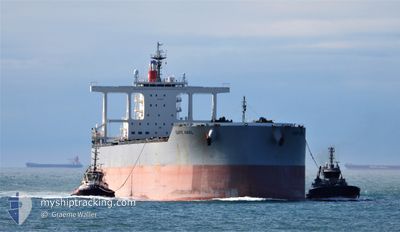
CAPE AMAL
Cargo
Current Trip
| Time Travelled | 28 days |
|---|---|
| Remaining Time | --- |
| Distance Travelled | 3942.75 nm |
| Remaining Distance | --- |
| AVG Speed | 11 Knots |
| MAX Speed | 17.7 Knots |
| AVG Wind | 9.9 knots |
| MAX Wind | 26.7 knots |
| MIN Temp | 6.9°C / 44.42°F |
| MAX Temp | 29.6°C / 85.28°F |
| Draught | 9 m |
| Position Received | 1 m ago |
Current Position
| Longitude | 118.61809° |
|---|---|
| Latitude | -20.10006° |
| Status | At anchor |
| Speed | |
| Course | 114° |
| Area | Indian Ocean |
| Station | T-AIS |
| Position Received | 1 m ago |
Info
Information
The current position of CAPE AMAL is in Indian Ocean with coordinates -20.10006° / 118.61809° as reported on 2024-04-19 20:25 by AIS to our vessel tracker app. The vessel's current speed is 0 Knots
The vessel CAPE AMAL (IMO: 9820879, MMSI: 431936000) is a Cargo It's sailing under the flag of [JP] Japan.
In this page you can find informations about the vessels current position, last detected port calls, and current voyage information. If the vessels is not in coverage by AIS you will find the latest position.
The current position of CAPE AMAL is detected by our AIS receivers and we are not responsible for the reliability of the data. The last position was recorded while the vessel was in Coverage by the Ais receivers of our vessel tracking app.
The current draught of CAPE AMAL as reported by AIS is 9 meters
Weather
| Temperature | 27.1°C / 80.78°F |
|---|---|
| Wind Speed | 22 knots |
| Direction | 108° ESE |
| Pressure | 1014.5 hPa |
| Humidity | 49 % |
| Cloud Coverage | 63 % |
Featured Company
Last Port Calls
| Port | Arrival | Departure | Time In Port |
|---|---|---|---|
| 2024-03-20 08:04 | 2024-03-22 18:17 | 2 d | |
| 2024-02-29 06:46 | 2024-03-01 17:52 | 1 d |
Most Visited Ports (Last year)
| Port | Arrivals | |
|---|---|---|
| 8 | ||
| 1 | ||
| 1 | ||
| 1 | ||
| 1 | ||
| 1 |
Last Trips
| Origin | Departure | Destination | Arrival | Distance | |
|---|---|---|---|---|---|
| 2024-03-02 01:52 | 2024-03-20 16:04 | 3560.40 nm | |||
| 2024-01-21 16:58 | 2024-02-29 14:46 | 6570.68 nm |
Events
| Time | Event | Details | Position / Dest | Info |
|---|---|---|---|---|
| 2024-04-19 19:04 | Status Changed | At anchor Default |
-20.09996 / 118.61823
AU PHE
|
Speed: Course: 118° |
| 2024-04-19 19:01 | Status Changed | Default At anchor |
-20.09989 / 118.61829
AU PHE
|
Speed: 0.1 kn Course: 121° |
| 2024-04-18 06:52 | Status Changed | At anchor Default |
-20.10205 / 118.61816
AU PHE
|
Speed: 0.1 kn Course: 76° |
| 2024-04-18 06:49 | Status Changed | Default At anchor |
-20.10200 / 118.61812
AU PHE
|
Speed: 0.2 kn Course: 81° |
| 2024-04-16 12:01 | Status Changed | At anchor Default |
-20.09899 / 118.62282
AU PHE
|
Speed: 0.1 kn Course: 197° |
| 2024-04-16 11:52 | Status Changed | Default At anchor |
-20.09898 / 118.62258
AU PHE
|
Speed: 0.1 kn Course: 191° |
| 2024-04-16 02:40 | Status Changed | At anchor Default |
-20.10082 / 118.62471
AU PHE
|
Speed: 0.3 kn Course: 260° |
| 2024-04-16 02:34 | Status Changed | Default At anchor |
-20.10043 / 118.62460
AU PHE
|
Speed: 0.3 kn Course: 254° |
| 2024-04-15 18:43 | Status Changed | At anchor Default |
-20.09944 / 118.62414
AU PHE
|
Speed: Course: 229° |
| 2024-04-15 18:40 | Status Changed | Default At anchor |
-20.09946 / 118.62421
AU PHE
|
Speed: 0.1 kn Course: 232° |