
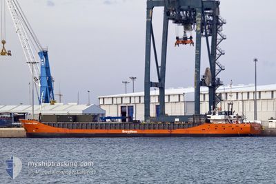
BREADBOX VIPER
General Cargo
Current Trip
| Time Travelled | 1 day |
|---|---|
| Remaining Time | 2 days |
| Distance Travelled | 183.47 nm |
| Remaining Distance | 498.57 nm |
| AVG Speed | 6.7 Knots |
| MAX Speed | 7.2 Knots |
| AVG Wind | 10.4 knots |
| MAX Wind | 13.3 knots |
| MIN Temp | 23.8°C / 74.84°F |
| MAX Temp | 27.3°C / 81.14°F |
| Draught | 3.5 m |
| Position Received | 15 d ago |
Current Position
| Longitude | -14.69941° |
|---|---|
| Latitude | 27.17405° |
| Status | Under way using engine |
| Speed | 8.7 Knots |
| Course | 223.3° |
| Area | North Atlantic Ocean |
| Station | T-AIS |
| Position Received | 15 d ago |
Info
Information
The current position of BREADBOX VIPER is in North Atlantic Ocean with coordinates 27.17405° / -14.69941° as reported on 2024-04-04 11:20 by AIS to our vessel tracker app. The vessel's current speed is 8.7 Knots and is heading at the port of MONROVIA. The estimated time of arrival as calculated by MyShipTracking vessel tracking app is 2024-04-22 19:28 LT
The vessel BREADBOX VIPER (IMO: 9201932, MMSI: 246199000) is a General Cargo that was built in 2000 ( 24 years old ). It's sailing under the flag of [NL] Netherlands.
In this page you can find informations about the vessels current position, last detected port calls, and current voyage information. If the vessels is not in coverage by AIS you will find the latest position.
The current position of BREADBOX VIPER is detected by our AIS receivers and we are not responsible for the reliability of the data. The last position was recorded while the vessel was in Coverage by the Ais receivers of our vessel tracking app.
The current draught of BREADBOX VIPER as reported by AIS is 3.5 meters
Weather
| Temperature | 24°C / 75.2°F |
|---|---|
| Wind Speed | 10 knots |
| Direction | 235° SW |
| Pressure | 1010.7 hPa |
| Humidity | 83.6 % |
| Cloud Coverage | 67 % |
Featured Company
Last Port Calls
| Port | Arrival | Departure | Time In Port |
|---|---|---|---|
| 2024-04-17 16:50 | 2024-04-18 17:48 | 1 d | |
| 2024-04-14 07:31 | 2024-04-14 16:24 | 8 h | |
| 2024-03-19 07:01 | 2024-03-20 01:00 | 17 h | |
| 2024-03-02 10:37 | 2024-03-18 15:56 | 16 d | |
| 2024-02-18 19:17 | |||
| 2024-01-31 21:04 |
Events
| Time | Event | Details | Position / Dest | Info |
|---|---|---|---|---|
| 2024-04-18 17:48 | PORT DEPARTURE |
|
10.65013 / -14.62518
LRMLW
|
Speed: Course: 105° |
| 2024-04-17 16:50 | STOP Moving |
10.65030 / -14.61875
[GN] KAMSAR
|
Speed: Course: 105° |
|
| 2024-04-17 16:50 | PORT ARRIVAL |
|
10.65030 / -14.61875
[GN] KAMSAR
|
Speed: 1.6 kn Course: 110° |
| 2024-04-17 14:07 | START Moving | 13.92 nm, South West of KAMSAR |
10.44101 / -14.75597
LRMLW
|
Speed: 6.1 kn Course: 92° |
| 2024-04-17 12:07 | STOP Moving | 14.09 nm, South West of KAMSAR |
10.44168 / -14.76211
LRMLW
|
Speed: 0.1 kn Course: 213° |
| 2024-04-16 13:53 | START Moving |
8.12510 / -14.58105
LRMLW
|
Speed: 3.2 kn Course: 313° |
|
| 2024-04-16 07:29 | STOP Moving |
8.09501 / -14.55737
LRMLW
|
Speed: 0.2 kn Course: 249° |
|
| 2024-04-14 16:24 | PORT DEPARTURE |
|
6.35217 / -10.81636
LRMLW
|
Speed: 5.9 kn Course: 302° |
| 2024-04-14 16:12 | START Moving |
6.34358 / -10.79999
[LR] MONROVIA
|
Speed: 4.2 kn Course: 280° |
|
| 2024-04-14 07:44 | STOP Moving |
6.34261 / -10.79641
[LR] MONROVIA
|
Speed: 0.3 kn Course: 204° |