
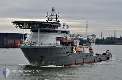
BOKA DA VINCI
Diving Support Vessel
Current Trip
JOHSTON OILFIELD
| Time Travelled | 11 h, 37 mins |
|---|---|
| Remaining Time | --- |
| Distance Travelled | 105.34 nm |
| Remaining Distance | --- |
| AVG Speed | 7.6 Knots |
| MAX Speed | 10.5 Knots |
| AVG Wind | 12.2 knots |
| MAX Wind | 21 knots |
| MIN Temp | 5.9°C / 42.62°F |
| MAX Temp | 6.1°C / 42.98°F |
| Draught | 6.3 m |
| Position Received | Now |
Current Position
| Longitude | 1.21959° |
|---|---|
| Latitude | 54.04546° |
| Status | Restricted manoeuverability |
| Speed | 0.1 Knots |
| Course | 299° |
| Area | North Sea |
| Station | T-AIS |
| Position Received | Now |
Info
Information
The current position of BOKA DA VINCI is in North Sea with coordinates 54.04546° / 1.21959° as reported on 2024-04-25 05:59 by AIS to our vessel tracker app. The vessel's current speed is 0.1 Knots
The vessel BOKA DA VINCI (IMO: 9441233, MMSI: 538003647) is a Diving Support Vessel that was built in 2011 ( 13 years old ). It's sailing under the flag of [MH] Marshall Is.
In this page you can find informations about the vessels current position, last detected port calls, and current voyage information. If the vessels is not in coverage by AIS you will find the latest position.
The current position of BOKA DA VINCI is detected by our AIS receivers and we are not responsible for the reliability of the data. The last position was recorded while the vessel was in Coverage by the Ais receivers of our vessel tracking app.
The current draught of BOKA DA VINCI as reported by AIS is 6.3 meters
Weather
| Temperature | 6.1°C / 42.98°F |
|---|---|
| Wind Speed | 21 knots |
| Direction | 246° WSW |
| Pressure | 1003.7 hPa |
| Humidity | 78.8 % |
| Cloud Coverage | 100 % |
Featured Company
Last Port Calls
| Port | Arrival | Departure | Time In Port |
|---|---|---|---|
| 2024-04-24 04:24 | 2024-04-24 18:23 | 13 h | |
| 2024-04-10 02:14 | 2024-04-10 12:52 | 10 h | |
| 2024-04-04 03:11 | 2024-04-04 10:39 | 7 h | |
| 2024-03-15 07:28 | 2024-03-15 18:53 | 11 h | |
| 2024-03-02 18:25 | 2024-03-05 09:50 | 2 d | |
| 2024-02-28 08:02 | 2024-03-02 15:57 | 3 d | |
| 2024-02-23 02:58 |
Most Visited Ports (Last year)
| Port | Arrivals | |
|---|---|---|
| 11 | ||
| 1 | ||
| 1 | ||
| 1 |
Last Trips
| Origin | Departure | Destination | Arrival | Distance | |
|---|---|---|---|---|---|
| 2024-04-10 13:52 | 2024-04-24 05:24 | 374.44 nm | |||
| 2024-04-04 11:39 | 2024-04-10 03:14 | 276.44 nm | |||
| 2024-03-15 18:53 | 2024-04-04 04:11 | 962.01 nm | |||
| 2024-03-05 09:50 | 2024-03-15 07:28 | 269.48 nm | |||
| 2024-03-02 15:57 | 2024-03-02 18:25 | 4.08 nm | |||
| 2024-02-23 03:58 | 2024-02-28 08:02 | 304.07 nm |
Events
| Time | Event | Details | Position / Dest | Info |
|---|---|---|---|---|
| 2024-04-25 05:16 | STOP Moving |
54.04548 / 1.21941
JOHSTON OILFIELD
|
Speed: 0.3 kn Course: 305° |
|
| 2024-04-25 05:06 | Status Changed | Restricted manoeuverability Under way using engine |
54.04621 / 1.21179
JOHSTON OILFIELD
|
Speed: 5.7 kn Course: 122.3° |
| 2024-04-25 04:34 | IN Coverage |
54.08315 / 1.11813
North Sea
JOHSTON OILFIELD
|
Speed: 10.5 kn Course: 121.8° |
|
| 2024-04-24 21:59 | OUT of Coverage |
54.70740 / -.47120
North Sea
JOHSTON OILFIELD
|
Speed: 9.6 kn Course: 121.5° |
|
| 2024-04-24 18:51 | ETA Changed | 2024/04/25 05:00 2024/04/24 05:00 |
54.91842 / -1.26896
JOHSTON OILFIELD
|
Speed: 9.8 kn Course: 102.3° |
| 2024-04-24 18:23 | START Moving | 1.2 nm, North East of SUNDERLAND |
54.92178 / -1.34823
JOHSTON OILFIELD
|
Speed: 5.2 kn Course: 65° |
| 2024-04-24 18:23 | PORT DEPARTURE |
|
54.92178 / -1.34823
JOHSTON OILFIELD
|
Speed: 0.7 kn Course: 29° |
| 2024-04-24 17:38 | Destination Changed | JOHSTON OILFIELD SUNDERLAND |
54.91338 / -1.36698
[GB] SUNDERLAND
|
Speed: Course: 37° |
| 2024-04-24 17:30 | Status Changed | Under way using engine Moored |
54.91339 / -1.36694
[GB] SUNDERLAND
|
Speed: Course: 37° |
| 2024-04-24 14:17 | IN Coverage |
54.91339 / -1.36698
North Sea
[GB] SUNDERLAND
|
Speed: Course: 138.8° |