
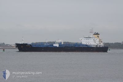
BIXBITE
Oil/Chemical Tanker
Current Trip
| Time Travelled | 6 days |
|---|---|
| Remaining Time | --- |
| Distance Travelled | 1028.34 nm |
| Remaining Distance | --- |
| AVG Speed | 11.7 Knots |
| MAX Speed | 14.2 Knots |
| AVG Wind | 11.8 knots |
| MAX Wind | 31.5 knots |
| MIN Temp | 10.7°C / 51.26°F |
| MAX Temp | 20.2°C / 68.36°F |
| Draught | 8 m |
| Position Received | 1 m ago |
Current Position
| Longitude | 26.58219° |
|---|---|
| Latitude | 40.30685° |
| Status | Under way using engine |
| Speed | 14 Knots |
| Course | 228.7° |
| Area | Sea of Marmara |
| Station | T-AIS |
| Position Received | 1 m ago |
Info
Information
The current position of BIXBITE is in Sea of Marmara with coordinates 40.30685° / 26.58219° as reported on 2024-04-25 01:18 by AIS to our vessel tracker app. The vessel's current speed is 14 Knots and is heading at the port of VALLETTA. The estimated time of arrival as calculated by MyShipTracking vessel tracking app is 2024-04-27 08:00 LT
The vessel BIXBITE (IMO: 9316610, MMSI: 229339000) is a Oil/Chemical Tanker that was built in 2009 ( 15 years old ). It's sailing under the flag of [MT] Malta.
In this page you can find informations about the vessels current position, last detected port calls, and current voyage information. If the vessels is not in coverage by AIS you will find the latest position.
The current position of BIXBITE is detected by our AIS receivers and we are not responsible for the reliability of the data. The last position was recorded while the vessel was in Coverage by the Ais receivers of our vessel tracking app.
The current draught of BIXBITE as reported by AIS is 8 meters
Weather
| Temperature | 15.3°C / 59.54°F |
|---|---|
| Wind Speed | 2 knots |
| Direction | 203° SSW |
| Pressure | 1004.5 hPa |
| Humidity | 86.5 % |
| Cloud Coverage | 100 % |
Featured Company
Last Port Calls
| Port | Arrival | Departure | Time In Port |
|---|---|---|---|
| 2024-04-17 20:47 | 2024-04-18 18:18 | 21 h | |
| 2024-04-15 08:55 | 2024-04-16 12:38 | 1 d | |
| 2024-04-07 19:51 | 2024-04-10 06:39 | 2 d | |
| 2024-04-04 09:20 | 2024-04-06 05:54 | 1 d | |
| 2024-03-25 20:03 | 2024-03-27 10:01 | 1 d | |
| 2024-03-20 02:05 | 2024-03-22 02:58 | 2 d | |
| 2024-03-06 04:23 | 2024-03-06 04:55 | 32 m | |
| 2024-03-04 11:51 | 2024-03-06 02:57 | 1 d | |
| 2024-02-24 22:01 | 2024-02-25 15:09 | 17 h | |
| 2024-02-20 09:26 | 2024-02-23 03:47 | 2 d |
Last Trips
| Origin | Departure | Destination | Arrival | Distance | |
|---|---|---|---|---|---|
| 2024-04-16 14:38 | 2024-04-17 22:47 | 6.68 nm | |||
| 2024-04-10 08:39 | 2024-04-15 10:55 | 642.78 nm | |||
| 2024-04-06 06:54 | 2024-04-07 21:51 | 505.83 nm | |||
| 2024-03-27 11:01 | 2024-04-04 10:20 | 574.23 nm | |||
| 2024-03-22 03:58 | 2024-03-25 21:03 | 527.69 nm | |||
| 2024-03-06 05:55 | 2024-03-20 03:05 | 1814.47 nm | |||
| 2024-03-06 03:57 | 2024-03-06 05:23 | 5.20 nm | |||
| 2024-02-25 16:09 | 2024-03-04 12:51 | 1509.54 nm | |||
| 2024-02-23 04:47 | 2024-02-24 23:01 | 497.23 nm | |||
| 2024-02-19 01:45 | 2024-02-20 10:26 | 6.29 nm |
Events
| Time | Event | Details | Position / Dest | Info |
|---|---|---|---|---|
| 2024-04-25 01:10 | Status Changed | Under way using engine Default |
40.32553 / 26.60972
MALTA
|
Speed: 14 kn Course: 224° |
| 2024-04-25 01:04 | IN Coverage |
40.32553 / 26.60972
Sea of Marmara
MALTA
|
Speed: 14 kn Course: 228.5° |
|
| 2024-04-24 22:56 | Status Changed | Default Under way using engine |
40.56479 / 27.06599
MALTA
|
Speed: 7 kn Course: 219.9° |
| 2024-04-24 22:46 | OUT of Coverage |
40.58705 / 27.10312
Sea of Marmara
MALTA
|
Speed: 7 kn Course: 219.9° |
|
| 2024-04-24 22:44 | START Moving | 1.18 nm, South of SARKOY |
40.58946 / 27.10592
MALTA
|
Speed: 4 kn Course: 220° |
| 2024-04-24 22:41 | Status Changed | Under way using engine At anchor |
40.59058 / 27.10777
MALTA
|
Speed: 0.8 kn Course: 258° |
| 2024-04-24 16:52 | Status Changed | At anchor Default |
40.59052 / 27.11136
MALTA
|
Speed: 0.1 kn Course: 259° |
| 2024-04-24 16:25 | Status Changed | Default At anchor |
40.59052 / 27.11141
MALTA
|
Speed: Course: 255° |
| 2024-04-24 15:22 | Status Changed | At anchor Default |
40.58987 / 27.11134
MALTA
|
Speed: Course: 294° |
| 2024-04-24 15:04 | Status Changed | Default At anchor |
40.58978 / 27.11125
MALTA
|
Speed: Course: 290° |