
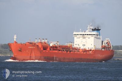
BELLIS THERESA
Oil/Chemical Tanker
Current Trip
| Time Travelled | 16 h, 2 mins |
|---|---|
| Remaining Time | 2 days |
| Distance Travelled | 172.76 nm |
| Remaining Distance | 835.80 nm |
| AVG Speed | 12.2 Knots |
| MAX Speed | 14.6 Knots |
| AVG Wind | 7.8 knots |
| MAX Wind | 13 knots |
| MIN Temp | 23.4°C / 74.12°F |
| MAX Temp | 24.6°C / 76.28°F |
| Draught | 7.2 m |
| Position Received | 2025-11-06 08:30 |
Current Position
| Longitude | --- |
|---|---|
| Latitude | --- |
| Status | Under way using engine |
| Speed | 13.5 Knots |
| Course | 172.9° |
| Area | North Atlantic Ocean |
| Station | T-AIS |
| Position Received | 2025-11-06 08:30 |
Info
Information
The current position of BELLIS THERESA is in North Atlantic Ocean with coordinates 11.20277° / -18.06404° as reported on 2025-11-06 08:30 by AIS to our vessel tracker app. The vessel's current speed is 13.5 Knots and is heading at the port of ABIDJAN. The estimated time of arrival as calculated by MyShipTracking vessel tracking app is 2025-12-12 04:01 LT
The vessel BELLIS THERESA (IMO: 9192375, MMSI: 248604000) is a Oil/Chemical Tanker that was built in 2000 ( 25 years old ). It's sailing under the flag of [MT] Malta.
In this page you can find informations about the vessels current position, last detected port calls, and current voyage information. If the vessels is not in coverage by AIS you will find the latest position.
The current position of BELLIS THERESA is detected by our AIS receivers and we are not responsible for the reliability of the data. The last position was recorded while the vessel was in Coverage by the Ais receivers of our vessel tracking app.
The current draught of BELLIS THERESA as reported by AIS is 7.2 meters
Weather
| Temperature | 23.5°C / 74.3°F |
|---|---|
| Wind Speed | 11 knots |
| Direction | 218° SW |
| Pressure | 1012.9 hPa |
| Humidity | 89.6 % |
| Cloud Coverage | 100 % |
Featured Company
Last Port Calls
| Port | Arrival | Departure | Time In Port |
|---|---|---|---|
| 2025-12-07 19:44 | 2025-12-09 00:57 | 1 d | |
| 2025-12-01 18:21 | 2025-12-04 17:13 | 2 d | |
| 2025-11-25 01:41 | 2025-11-26 21:37 | 1 d | |
| 2025-11-14 01:32 | 2025-11-14 13:00 | 11 h | |
| 2025-11-09 21:38 | 2025-11-11 04:38 | 1 d | |
| 2025-11-04 18:23 | 2025-11-05 09:45 | 15 h | |
| 2025-10-22 12:02 | 2025-10-26 13:36 | 4 d | |
| 2025-10-19 00:57 | 2025-10-20 20:22 | 1 d | |
| 2025-10-16 08:07 | 2025-10-18 09:01 | 2 d | |
| 2025-10-09 15:20 | 2025-10-09 16:20 | 59 m |
Last Trips
| Origin | Departure | Destination | Arrival | Distance | |
|---|---|---|---|---|---|
| 2025-12-04 17:13 | 2025-12-07 19:44 | 260.05 nm | |||
| 2025-11-26 21:37 | 2025-12-01 18:21 | 283.69 nm | |||
| 2025-11-14 13:00 | 2025-11-25 01:41 | 1347.13 nm | |||
| 2025-11-11 04:38 | 2025-11-14 01:32 | 364.11 nm | |||
| 2025-11-05 09:45 | 2025-11-09 21:38 | 1286.98 nm | |||
| 2025-10-26 13:36 | 2025-11-04 18:23 | 2711.15 nm | |||
| 2025-10-20 20:22 | 2025-10-22 12:02 | 414.62 nm | |||
| 2025-10-18 09:01 | 2025-10-19 00:57 | 176.67 nm | |||
| 2025-10-09 16:20 | 2025-10-16 08:07 | 732.36 nm | |||
| 2025-10-09 14:34 | 2025-10-09 15:20 | 2.74 nm |
Events
| Time | Event | Details | Position / Dest | Info |
|---|---|---|---|---|
| 2025-12-08 23:57 | PORT DEPARTURE |
|
.28342 / 9.47801
CIABJ
|
Speed: 4.9 kn Course: 254° |
| 2025-12-08 23:33 | START Moving |
.28232 / 9.50557
[GA] OWENDO
|
Speed: 3.3 kn Course: 73° |
|
| 2025-12-07 18:45 | STOP Moving |
.28446 / 9.50818
[GA] OWENDO
|
Speed: Course: 72° |
|
| 2025-12-07 18:44 | PORT ARRIVAL |
|
.28446 / 9.50818
[GA] OWENDO
|
Speed: 4.2 kn Course: 64° |
| 2025-12-07 17:29 | START Moving | 5.75 nm, South of LIBREVILLE |
.30559 / 9.40986
CIABJ
|
Speed: 6.7 kn Course: 130° |
| 2025-12-05 12:01 | STOP Moving | 5.7 nm, South of LIBREVILLE |
.30748 / 9.40582
CIABJ
|
Speed: 0.1 kn Course: 86° |
| 2025-12-04 16:13 | PORT DEPARTURE |
|
4.03002 / 9.65498
CIABJ
|
Speed: 7 kn Course: 238° |
| 2025-12-04 15:49 | START Moving |
4.05347 / 9.68890
[CM] DOUALA
|
Speed: 3.4 kn Course: 219° |
|
| 2025-12-01 17:25 | STOP Moving |
4.05604 / 9.69217
[CM] DOUALA
|
Speed: 0.1 kn Course: 38° |
|
| 2025-12-01 17:21 | PORT ARRIVAL |
|
4.05599 / 9.69217
[CM] DOUALA
|
Speed: 1.2 kn Course: 43° |