
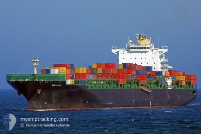
BELLAVIA
Container Ship
Current Trip
| Time Travelled | 29 days |
|---|---|
| Remaining Time | --- |
| Distance Travelled | 8664.10 nm |
| Remaining Distance | --- |
| AVG Speed | 12 Knots |
| MAX Speed | 19.7 Knots |
| AVG Wind | 16.9 knots |
| MAX Wind | 31.5 knots |
| MIN Temp | 5.7°C / 42.26°F |
| MAX Temp | 29.2°C / 84.56°F |
| Draught | 12.2 m |
| Position Received | 5 d ago |
Current Position
| Longitude | 19.39437° |
|---|---|
| Latitude | -35.05146° |
| Status | Under way using engine |
| Speed | 12.1 Knots |
| Course | 111.6° |
| Area | South Atlantic Ocean |
| Station | T-AIS |
| Position Received | 5 d ago |
Info
Information
The current position of BELLAVIA is in South Atlantic Ocean with coordinates -35.05146° / 19.39437° as reported on 2024-04-13 17:33 by AIS to our vessel tracker app. The vessel's current speed is 12.1 Knots and is heading at the port of DA CHAN BAY. The estimated time of arrival as calculated by MyShipTracking vessel tracking app is 2024-05-07 02:00 LT
The vessel BELLAVIA (IMO: 9290440, MMSI: 636092778) is a Container Ship that was built in 2005 ( 19 years old ). It's sailing under the flag of [LR] Liberia.
In this page you can find informations about the vessels current position, last detected port calls, and current voyage information. If the vessels is not in coverage by AIS you will find the latest position.
The current position of BELLAVIA is detected by our AIS receivers and we are not responsible for the reliability of the data. The last position was recorded while the vessel was in Coverage by the Ais receivers of our vessel tracking app.
The current draught of BELLAVIA as reported by AIS is 12.2 meters
Weather
| Temperature | 23.1°C / 73.58°F |
|---|---|
| Wind Speed | 21 knots |
| Direction | 63° ENE |
| Pressure | 1018.4 hPa |
| Humidity | 78.7 % |
| Cloud Coverage | 100 % |
Featured Company
Most Visited Ports (Last year)
| Port | Arrivals | |
|---|---|---|
| 8 | ||
| 7 | ||
| 6 | ||
| 6 | ||
| 5 | ||
| 5 |
Last Trips
| Origin | Departure | Destination | Arrival | Distance | |
|---|---|---|---|---|---|
| 2024-03-19 12:21 | 2024-03-19 17:36 | 63.72 nm | |||
| 2024-03-13 22:53 | 2024-03-18 15:38 | 1091.39 nm | |||
| 2024-02-04 13:42 | 2024-03-11 20:05 | 14198.91 nm | |||
| 2024-01-31 05:58 | 2024-02-03 14:22 | 62.54 nm |
Events
| Time | Event | Details | Position / Dest | Info |
|---|---|---|---|---|
| 2024-04-13 17:38 | Status Changed | Default Under way using engine |
-35.05765 / 19.41361
TRDRC>CNDCB
|
Speed: 12.1 kn Course: 111.6° |
| 2024-04-13 17:33 | Status Changed | Under way using engine Default |
-35.05146 / 19.39437
TRDRC>CNDCB
|
Speed: 12.1 kn Course: 111° |
| 2024-04-13 17:33 | OUT of Coverage |
-35.05146 / 19.39437
South Atlantic Ocean
TRDRC>CNDCB
|
Speed: 12.1 kn Course: 111.6° |
|
| 2024-04-13 17:12 | Status Changed | Default Under way using engine |
-35.02444 / 19.31043
TRDRC>CNDCB
|
Speed: 12.3 kn Course: 110.1° |
| 2024-04-13 17:08 | Status Changed | Under way using engine Default |
-35.01942 / 19.29404
TRDRC>CNDCB
|
Speed: 12.1 kn Course: 112° |
| 2024-04-13 16:20 | Status Changed | Default Under way using engine |
-34.95943 / 19.11114
TRDRC>CNDCB
|
Speed: 11.9 kn Course: 114.5° |
| 2024-04-13 15:29 | Status Changed | Under way using engine Default |
-34.90042 / 18.92432
TRDRC>CNDCB
|
Speed: 11.6 kn Course: 106° |
| 2024-04-13 15:27 | Status Changed | Default Under way using engine |
-34.89774 / 18.91512
TRDRC>CNDCB
|
Speed: 11.4 kn Course: 111.5° |
| 2024-04-13 15:23 | Status Changed | Under way using engine Default |
-34.89291 / 18.89940
TRDRC>CNDCB
|
Speed: 11.4 kn Course: 114° |
| 2024-04-13 14:55 | Status Changed | Default Under way using engine |
-34.85948 / 18.80371
TRDRC>CNDCB
|
Speed: 11.2 kn Course: 113.2° |