
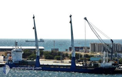
BBC EMSLAND
General Cargo
Current Trip
| Time Travelled | 10 days |
|---|---|
| Remaining Time | --- |
| Distance Travelled | 668.12 nm |
| Remaining Distance | --- |
| AVG Speed | 11 Knots |
| MAX Speed | 12.6 Knots |
| AVG Wind | 13.6 knots |
| MAX Wind | 28 knots |
| MIN Temp | 12.3°C / 54.14°F |
| MAX Temp | 19°C / 66.2°F |
| Draught | 7 m |
| Position Received | 7 d ago |
Current Position
| Longitude | -71.86293° |
|---|---|
| Latitude | -33.05027° |
| Status | Under way using engine |
| Speed | 11.5 Knots |
| Course | 182.6° |
| Area | South Pacific Ocean |
| Station | T-AIS |
| Position Received | 7 d ago |
Info
Information
The current position of BBC EMSLAND is in South Pacific Ocean with coordinates -33.05027° / -71.86293° as reported on 2024-04-17 22:31 by AIS to our vessel tracker app. The vessel's current speed is 11.5 Knots
The vessel BBC EMSLAND (IMO: 9511648, MMSI: 305561000) is a General Cargo that was built in 2010 ( 14 years old ). It's sailing under the flag of [AG] Antigua Barbuda.
In this page you can find informations about the vessels current position, last detected port calls, and current voyage information. If the vessels is not in coverage by AIS you will find the latest position.
The current position of BBC EMSLAND is detected by our AIS receivers and we are not responsible for the reliability of the data. The last position was recorded while the vessel was in Coverage by the Ais receivers of our vessel tracking app.
The current draught of BBC EMSLAND as reported by AIS is 7 meters
Weather
| Temperature | 14.6°C / 58.28°F |
|---|---|
| Wind Speed | 8 knots |
| Direction | 220° SW |
| Pressure | 1016.2 hPa |
| Humidity | 64.5 % |
| Cloud Coverage | 45 % |
Featured Company
Most Visited Ports (Last year)
| Port | Arrivals | |
|---|---|---|
| 4 | ||
| 3 | ||
| 2 | ||
| 2 | ||
| 2 | ||
| 1 |
Last Trips
| Origin | Departure | Destination | Arrival | Distance | |
|---|---|---|---|---|---|
| 2024-03-10 19:38 | 2024-04-13 07:02 | 6336.33 nm | |||
| 2024-03-05 07:42 | 2024-03-10 05:55 | 1377.38 nm | |||
| 2024-02-29 21:04 | 2024-03-02 14:16 | 505.39 nm | |||
| 2024-02-14 21:12 | 2024-02-28 10:50 | 3961.84 nm | |||
| 2024-01-27 21:54 | 2024-02-12 01:36 | 1693.08 nm |
Events
| Time | Event | Details | Position / Dest | Info |
|---|---|---|---|---|
| 2024-04-18 02:34 | STOP Moving | 2.54 nm, South West of SAN ANTONIO |
-33.60901 / -71.66276
CLSAI
|
Speed: 0.1 kn Course: 238° |
| 2024-04-17 22:37 | Status Changed | Default Under way using engine |
-33.06785 / -71.86364
CLSAI
|
Speed: 11.5 kn Course: 182.6° |
| 2024-04-17 22:31 | OUT of Coverage |
-33.05027 / -71.86293
South Pacific Ocean
CLSAI
|
Speed: 11.5 kn Course: 182.6° |
|
| 2024-04-17 18:47 | Draught Changed | 7 6.2 |
-32.34804 / -71.83850
CLSAI
|
Speed: 11.2 kn Course: 179.9° |
| 2024-04-17 18:47 | Destination Changed | CLSAI CL SDI |
-32.34804 / -71.83850
CLSAI
|
Speed: 11.2 kn Course: 179.9° |
| 2024-04-17 18:47 | ETA Changed | 2024/04/17 23:00 2024/03/29 00:00 |
-32.34804 / -71.83850
CLSAI
|
Speed: 11.2 kn Course: 179.9° |
| 2024-04-17 18:34 | Status Changed | Under way using engine Default |
-32.30612 / -71.83488
CL SDI
|
Speed: 11.4 kn Course: 181° |
| 2024-04-17 18:28 | Status Changed | Default Under way using engine |
-32.28988 / -71.83415
CL SDI
|
Speed: 11.3 kn Course: 181.7° |
| 2024-04-17 18:23 | Status Changed | Under way using engine Default |
-32.27307 / -71.83350
CL SDI
|
Speed: 11.3 kn Course: 181° |
| 2024-04-17 18:07 | Status Changed | Default Under way using engine |
-32.22208 / -71.83141
CL SDI
|
Speed: 11.2 kn Course: 180.8° |