
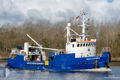
BALTIC TAUCHER II
Offshore Supply Ship
Current Trip
| Trip Time | 7 h, 30 mins |
|---|---|
| Trip Distance | 12.30 nm |
| AVG Speed | 6.5 Knots |
| MAX Speed | 8.4 Knots |
| Draught | 2.8 m |
| AVG Wind | 6.2 knots |
| MAX Wind | 9 knots |
| MIN Temp | 9°C / 48.2°F |
| MAX Temp | 10.2°C / 50.36°F |
| Position Received | 1 m ago |
Current Position
| Longitude | 12.09223° |
|---|---|
| Latitude | 54.11153° |
| Status | Moored |
| Speed | |
| Course | 62° |
| Area | Baltic Sea |
| Station | T-AIS |
| Position Received | 1 m ago |
Info
Information
The current position of BALTIC TAUCHER II is in Baltic Sea with coordinates 54.11153° / 12.09223° as reported on 2024-04-16 23:16 by AIS to our vessel tracker app. The vessel's current speed is 0 Knots and is currently inside the port of ROSTOCK.
The vessel BALTIC TAUCHER II (IMO: 9096387, MMSI: 211436320) is a Offshore Supply Ship that was built in 1978 ( 46 years old ). It's sailing under the flag of [DE] Germany.
In this page you can find informations about the vessels current position, last detected port calls, and current voyage information. If the vessels is not in coverage by AIS you will find the latest position.
The current position of BALTIC TAUCHER II is detected by our AIS receivers and we are not responsible for the reliability of the data. The last position was recorded while the vessel was in Coverage by the Ais receivers of our vessel tracking app.
The current draught of BALTIC TAUCHER II as reported by AIS is 2.8 meters
Weather
| Temperature | 3.4°C / 38.12°F |
|---|---|
| Wind Speed | --- |
| Direction | 262° W |
| Pressure | 1005.8 hPa |
| Humidity | 89.5 % |
| Cloud Coverage | 80 % |
Featured Company
Last Trips
| Origin | Departure | Destination | Arrival | Distance | |
|---|---|---|---|---|---|
| 2024-04-15 11:48 | 2024-04-15 19:18 | 12.30 nm | |||
| 2024-04-03 13:41 | 2024-04-04 22:34 | 121.46 nm | |||
| 2024-03-12 23:36 | 2024-03-14 01:20 | 130.11 nm | |||
| 2024-03-04 09:20 | 2024-03-04 13:14 | 10.88 nm | |||
| 2024-02-27 23:19 | 2024-02-29 00:30 | 130.73 nm |
Events
| Time | Event | Details | Position / Dest | Info |
|---|---|---|---|---|
| 2024-04-15 18:19 | Status Changed | Moored Under way using engine |
54.11154 / 12.09222
[DE] ROSTOCK
|
Speed: Course: 61° |
| 2024-04-15 18:03 | STOP Moving |
54.11153 / 12.09217
[DE] ROSTOCK
|
Speed: 0.3 kn Course: 104° |
|
| 2024-04-15 17:18 | PORT ARRIVAL |
|
54.18765 / 12.08831
[DE] ROSTOCK
|
Speed: 7.9 kn Course: 161.6° |
| 2024-04-15 16:36 | START Moving | 9.09 nm, North of ROSTOCK |
54.27745 / 12.13413
ROSTOCK
|
Speed: 6.6 kn Course: 202.1° |
| 2024-04-15 16:33 | Status Changed | Under way using engine At anchor |
54.27986 / 12.13517
ROSTOCK
|
Speed: 1.3 kn Course: 47° |
| 2024-04-15 13:14 | Status Changed | At anchor Under way using engine |
54.28145 / 12.13470
ROSTOCK
|
Speed: 0.1 kn Course: 2° |
| 2024-04-15 11:09 | STOP Moving | 9.2 nm, North of ROSTOCK |
54.27924 / 12.13448
ROSTOCK
|
Speed: 0.3 kn Course: 344° |
| 2024-04-15 11:06 | START Moving | 9.23 nm, North of ROSTOCK |
54.27963 / 12.13580
ROSTOCK
|
Speed: 3.7 kn Course: 173° |
| 2024-04-15 10:36 | STOP Moving | 9.34 nm, North of ROSTOCK |
54.28144 / 12.13555
ROSTOCK
|
Speed: 0.3 kn Course: 53° |
| 2024-04-15 09:48 | PORT DEPARTURE |
|
54.19018 / 12.08956
ROSTOCK
|
Speed: 7.1 kn Course: 20° |