
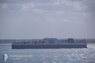
ATLANTIC SKY
Cargo
Current Trip
| Time Travelled | 1 day |
|---|---|
| Remaining Time | --- |
| Distance Travelled | 581.97 nm |
| Remaining Distance | --- |
| AVG Speed | 14.7 Knots |
| MAX Speed | 18.3 Knots |
| AVG Wind | 9.1 knots |
| MAX Wind | 14 knots |
| MIN Temp | 6.8°C / 44.24°F |
| MAX Temp | 11.7°C / 53.06°F |
| Draught | 10.4 m |
| Position Received | 15 h, 46 m ago |
Current Position
| Longitude | -11.19251° |
|---|---|
| Latitude | 51.45376° |
| Status | Under way using engine |
| Speed | 16.8 Knots |
| Course | 275.3° |
| Area | North Atlantic Ocean |
| Station | T-AIS |
| Position Received | 15 h, 46 m ago |
Info
Information
The current position of ATLANTIC SKY is in North Atlantic Ocean with coordinates 51.45376° / -11.19251° as reported on 2024-04-18 17:04 by AIS to our vessel tracker app. The vessel's current speed is 16.8 Knots and is heading at the port of HALIFAX. The estimated time of arrival as calculated by MyShipTracking vessel tracking app is 2024-04-24 08:00 LT
The vessel ATLANTIC SKY (IMO: 9670602, MMSI: 215804000) is a Cargo It's sailing under the flag of [MT] Malta.
In this page you can find informations about the vessels current position, last detected port calls, and current voyage information. If the vessels is not in coverage by AIS you will find the latest position.
The current position of ATLANTIC SKY is detected by our AIS receivers and we are not responsible for the reliability of the data. The last position was recorded while the vessel was in Coverage by the Ais receivers of our vessel tracking app.
The current draught of ATLANTIC SKY as reported by AIS is 10.4 meters
Weather
| Temperature | 10.7°C / 51.26°F |
|---|---|
| Wind Speed | 3 knots |
| Direction | 12° NNE |
| Pressure | 1027.7 hPa |
| Humidity | 84.5 % |
| Cloud Coverage | 33 % |
Featured Company
Last Port Calls
| Port | Arrival | Departure | Time In Port |
|---|---|---|---|
| 2024-04-16 15:23 | 2024-04-17 19:18 | 1 d | |
| 2024-04-12 21:38 | 2024-04-13 23:02 | 1 d | |
| 2024-04-10 15:14 | 2024-04-11 14:50 | 23 h | |
| 2024-04-05 18:39 | 2024-04-07 21:34 | 2 d | |
| 2024-03-29 09:10 | 2024-03-29 21:12 | 12 h | |
| 2024-03-26 13:07 | 2024-03-27 00:41 | 11 h | |
| 2024-03-25 01:41 | 2024-03-26 02:41 | 1 d | |
| 2024-03-24 09:05 | 2024-03-25 01:16 | 16 h | |
| 2024-03-21 10:34 | 2024-03-22 22:25 | 1 d | |
| 2024-03-19 10:15 | 2024-03-19 21:43 | 11 h |
Last Trips
| Origin | Departure | Destination | Arrival | Distance | |
|---|---|---|---|---|---|
| 2024-04-14 01:02 | 2024-04-16 16:23 | 729.74 nm | |||
| 2024-04-11 16:50 | 2024-04-12 23:38 | 405.20 nm | |||
| 2024-04-07 22:34 | 2024-04-10 17:14 | 994.48 nm | |||
| 2024-03-29 18:12 | 2024-04-05 19:39 | 2534.28 nm | |||
| 2024-03-26 20:41 | 2024-03-29 06:10 | 780.24 nm | |||
| 2024-03-25 22:41 | 2024-03-26 09:07 | 163.20 nm | |||
| 2024-03-24 21:16 | 2024-03-24 21:41 | 0.78 nm | |||
| 2024-03-22 18:25 | 2024-03-24 05:05 | 419.96 nm | |||
| 2024-03-19 18:43 | 2024-03-21 06:34 | 590.51 nm | |||
| 2024-03-13 00:17 | 2024-03-19 07:15 | 2470.28 nm |
Events
| Time | Event | Details | Position / Dest | Info |
|---|---|---|---|---|
| 2024-04-18 17:26 | Status Changed | Default Under way using engine |
51.46333 / -11.35667
GBLIV>CAHAL
|
Speed: 16.8 kn Course: 275.3° |
| 2024-04-18 17:04 | OUT of Coverage |
51.45376 / -11.19251
North Atlantic Ocean
GBLIV>CAHAL
|
Speed: 16.8 kn Course: 275.3° |
|
| 2024-04-18 17:03 | Status Changed | Under way using engine Default |
51.45319 / -11.18354
GBLIV>CAHAL
|
Speed: 17 kn Course: 277° |
| 2024-04-18 16:50 | IN Coverage |
51.45376 / -11.19251
North Atlantic Ocean
GBLIV>CAHAL
|
Speed: 16.8 kn Course: 275.3° |
|
| 2024-04-18 15:20 | Status Changed | Default Under way using engine |
51.39500 / -10.41333
GBLIV>CAHAL
|
Speed: 16.9 kn Course: 277.7° |
| 2024-04-18 15:02 | Detected in Sea | Irish part of the North Atlantic Ocean |
51.38482 / -10.28446
North Atlantic Ocean
GBLIV>CAHAL
|
Speed: 16.9 kn Course: 277.7° |
| 2024-04-18 15:02 | Status Changed | Under way using engine Default |
51.38482 / -10.28446
GBLIV>CAHAL
|
Speed: 16.9 kn Course: 278° |
| 2024-04-18 15:02 | OUT of Coverage |
51.38482 / -10.28446
North Atlantic Ocean
GBLIV>CAHAL
|
Speed: 16.9 kn Course: 277.7° |
|
| 2024-04-18 14:32 | Status Changed | Default Under way using engine |
51.36666 / -10.05667
GBLIV>CAHAL
|
Speed: 17 kn Course: 276.6° |
| 2024-04-18 05:23 | Change Sea Area | Irish part of the Celtic Sea Irish part of the Irish Sea and St. George's Channel |
52.13555 / -6.19689
Celtic Sea
GBLIV>CAHAL
|
Speed: 16.2 kn Course: 240.4° |