
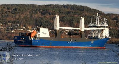
ATLANTIC DAWN
General Cargo
Current Trip
PA PTY
| Time Travelled | 19 days |
|---|---|
| Remaining Time | --- |
| Distance Travelled | 6473.50 nm |
| Remaining Distance | --- |
| AVG Speed | 13.8 Knots |
| MAX Speed | 15.9 Knots |
| AVG Wind | 14 knots |
| MAX Wind | 28 knots |
| MIN Temp | 10.5°C / 50.9°F |
| MAX Temp | 29.1°C / 84.38°F |
| Draught | 6 m |
| Position Received | 2 d ago |
Current Position
| Longitude | -87.62013° |
|---|---|
| Latitude | -2.22923° |
| Status | Under way using engine |
| Speed | 14.4 Knots |
| Course | 45.6° |
| Area | South Pacific Ocean |
| Station | T-AIS |
| Position Received | 2 d ago |
Info
Information
The current position of ATLANTIC DAWN is in South Pacific Ocean with coordinates -2.22923° / -87.62013° as reported on 2024-04-16 00:06 by AIS to our vessel tracker app. The vessel's current speed is 14.4 Knots
The vessel ATLANTIC DAWN (IMO: 9671450, MMSI: 244790606) is a General Cargo that was built in 2013 ( 11 years old ). It's sailing under the flag of [NL] Netherlands.
In this page you can find informations about the vessels current position, last detected port calls, and current voyage information. If the vessels is not in coverage by AIS you will find the latest position.
The current position of ATLANTIC DAWN is detected by our AIS receivers and we are not responsible for the reliability of the data. The last position was recorded while the vessel was in Coverage by the Ais receivers of our vessel tracking app.
The current draught of ATLANTIC DAWN as reported by AIS is 6 meters
Weather
| Temperature | 28.2°C / 82.76°F |
|---|---|
| Wind Speed | 4 knots |
| Direction | 197° SSW |
| Pressure | 1008.2 hPa |
| Humidity | 72.2 % |
| Cloud Coverage | 98 % |
Featured Company
Last Trips
| Origin | Departure | Destination | Arrival | Distance | |
|---|---|---|---|---|---|
| 2024-03-12 17:15 | 2024-03-27 21:00 | 748.23 nm | |||
| 2024-03-08 15:43 | 2024-03-11 17:57 | 707.30 nm | |||
| 2024-03-02 19:48 | 2024-03-07 22:08 | 1394.50 nm | |||
| 2024-02-16 10:54 | 2024-02-29 11:29 | 114.53 nm | |||
| 2024-01-23 10:00 | 2024-02-15 00:48 | 7729.81 nm |
Events
| Time | Event | Details | Position / Dest | Info |
|---|---|---|---|---|
| 2024-04-17 21:41 | START Moving |
6.32167 / -81.28500
PA PTY
|
Speed: 9 kn Course: 56° |
|
| 2024-04-17 21:20 | STOP Moving |
6.31667 / -81.28500
PA PTY
|
Speed: Course: -1° |
|
| 2024-04-16 00:12 | Status Changed | Default Under way using engine |
-2.21305 / -87.60370
PA PTY
|
Speed: 14.4 kn Course: 45.6° |
| 2024-04-16 00:06 | OUT of Coverage |
-2.22923 / -87.62013
South Pacific Ocean
|
Speed: 14.4 kn Course: 45.6° |
|
| 2024-04-15 23:49 | Status Changed | Under way using engine Default |
-2.27536 / -87.66686
PA PTY
|
Speed: 14 kn Course: 45° |
| 2024-04-15 23:47 | Status Changed | Default Under way using engine |
-2.28167 / -87.67333
PA PTY
|
Speed: 14.3 kn Course: 45.5° |
| 2024-04-15 23:41 | Status Changed | Under way using engine Default |
-2.29846 / -87.68999
PA PTY
|
Speed: 14 kn Course: 46° |
| 2024-04-15 23:24 | IN Coverage |
-2.29846 / -87.68999
South Pacific Ocean
|
Speed: 14.2 kn Course: 45.3° |
|
| 2024-04-15 22:35 | Status Changed | Default Under way using engine |
-2.47833 / -87.87334
PA PTY
|
Speed: 13.4 kn Course: 47.9° |
| 2024-04-15 22:29 | OUT of Coverage |
-2.49478 / -87.89132
South Pacific Ocean
|
Speed: 13.4 kn Course: 47.9° |