
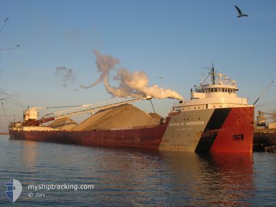
ARTHUR M. ANDERSON
Self Discharging Bulk Carrier
Current Trip
| Time Travelled | 14 h, 6 mins |
|---|---|
| Remaining Time | 14 h, 37 mins |
| Distance Travelled | 161.13 nm |
| Remaining Distance | 174.01 nm |
| AVG Speed | 11.7 Knots |
| MAX Speed | 12.5 Knots |
| AVG Wind | 22 knots |
| MAX Wind | 27 knots |
| MIN Temp | 1.3°C / 34.34°F |
| MAX Temp | 5.3°C / 41.54°F |
| Draught | 0 m |
| Position Received | 1 d ago |
Current Position
| Longitude | -83.80331° |
|---|---|
| Latitude | 45.55380° |
| Status | Under way using engine |
| Speed | 12.5 Knots |
| Course | 349.7° |
| Area | --- |
| Station | T-AIS |
| Position Received | 1 d ago |
Info
Information
The current position of ARTHUR M. ANDERSON is in --- with coordinates 45.55380° / -83.80331° as reported on 2024-04-18 15:30 by AIS to our vessel tracker app. The vessel's current speed is 12.5 Knots and is heading at the port of DULUTH SUPERIOR. The estimated time of arrival as calculated by MyShipTracking vessel tracking app is 2024-04-20 10:26 LT
The vessel ARTHUR M. ANDERSON (IMO: 5025691, MMSI: 366972020) is a Self Discharging Bulk Carrier that was built in 1952 ( 72 years old ). It's sailing under the flag of [US] USA.
In this page you can find informations about the vessels current position, last detected port calls, and current voyage information. If the vessels is not in coverage by AIS you will find the latest position.
The current position of ARTHUR M. ANDERSON is detected by our AIS receivers and we are not responsible for the reliability of the data. The last position was recorded while the vessel was in Coverage by the Ais receivers of our vessel tracking app.
Weather
| Temperature | 1.6°C / 34.88°F |
|---|---|
| Wind Speed | 27 knots |
| Direction | 259° W |
| Pressure | 1010.7 hPa |
| Humidity | 74.3 % |
| Cloud Coverage | 100 % |
Featured Company
Last Port Calls
| Port | Arrival | Departure | Time In Port |
|---|---|---|---|
| 2024-04-19 03:19 | 2024-04-19 05:43 | 2 h | |
| 2024-04-16 22:17 | 2024-04-18 14:37 | 1 d | |
| 2024-04-15 08:40 | 2024-04-15 19:41 | 11 h | |
| 2024-04-13 17:14 | 2024-04-13 18:03 | 49 m | |
| 2024-04-11 01:48 | 2024-04-12 12:46 | 1 d | |
| 2024-04-09 22:36 | 2024-04-10 00:58 | 2 h | |
| 2024-04-08 07:43 | 2024-04-08 16:43 | 8 h | |
| 2024-04-06 20:07 | 2024-04-06 23:42 | 3 h | |
| 2024-04-05 05:24 | 2024-04-05 15:53 | 10 h | |
| 2024-04-02 20:31 | 2024-04-02 22:46 | 2 h |
Most Visited Ports (Last year)
| Port | Arrivals | |
|---|---|---|
| 65 | ||
| 22 | ||
| 21 | ||
| 17 | ||
| 14 | ||
| 8 |
Last Trips
| Origin | Departure | Destination | Arrival | Distance | |
|---|---|---|---|---|---|
| 2024-04-18 10:37 | 2024-04-18 23:19 | 72.46 nm | |||
| 2024-04-15 14:41 | 2024-04-16 18:17 | 338.75 nm | |||
| 2024-04-13 14:03 | 2024-04-15 03:40 | 383.55 nm | |||
| 2024-04-12 07:46 | 2024-04-13 13:14 | 343.51 nm | |||
| 2024-04-09 20:58 | 2024-04-10 20:48 | 318.72 nm | |||
| 2024-04-08 11:43 | 2024-04-09 18:36 | 367.17 nm | |||
| 2024-04-06 19:42 | 2024-04-08 02:43 | 383.87 nm | |||
| 2024-04-05 10:53 | 2024-04-06 16:07 | 324.25 nm | |||
| 2024-04-02 18:46 | 2024-04-05 00:24 | 468.95 nm | |||
| 2024-04-01 08:47 | 2024-04-02 16:31 | 369.61 nm |
Events
| Time | Event | Details | Position / Dest | Info |
|---|---|---|---|---|
| 2024-04-19 05:43 | PORT DEPARTURE |
|
46.48333 / -84.44167
DULUTH
|
Speed: Course: -1° |
| 2024-04-19 03:19 | PORT ARRIVAL |
|
46.49833 / -84.32500
[CA] SAULT STE MARIE
|
Speed: 2.1 kn Course: 331° |
| 2024-04-18 15:35 | Status Changed | Default Under way using engine |
45.56833 / -83.80666
DULUTH
|
Speed: 12.5 kn Course: 349.7° |
| 2024-04-18 15:30 | OUT of Coverage |
45.55380 / -83.80331
DULUTH
|
Speed: 12.5 kn Course: 349.7° |
|
| 2024-04-18 14:46 | START Moving | 0.5 nm, North of CALCITE |
45.41994 / -83.77050
DULUTH
|
Speed: 3.1 kn Course: 318° |
| 2024-04-18 14:41 | STOP Moving | 0.47 nm, North East of CALCITE |
45.41845 / -83.76775
DULUTH
|
Speed: 0.3 kn Course: 259° |
| 2024-04-18 14:37 | PORT DEPARTURE |
|
45.41763 / -83.76944
DULUTH
|
Speed: 3 kn Course: 233° |
| 2024-04-18 14:35 | START Moving |
45.41693 / -83.77161
[US] CALCITE
|
Speed: 3.1 kn Course: 237° |
|
| 2024-04-18 13:58 | ETA Changed | 2024/04/20 04:00 2024/04/17 00:00 |
45.41087 / -83.78566
[US] CALCITE
|
Speed: Course: 236° |
| 2024-04-18 13:52 | Destination Changed | DULUTH CALCITE |
45.41087 / -83.78565
[US] CALCITE
|
Speed: 0.1 kn Course: 236° |