
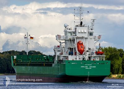
ARKLOW ARCHER
Cargo
Current Trip
| Trip Time | 2 days |
|---|---|
| Trip Distance | 635.53 nm |
| AVG Speed | 8.9 Knots |
| MAX Speed | 12.2 Knots |
| Draught | 6 m |
| AVG Wind | 11.6 knots |
| MAX Wind | 22 knots |
| MIN Temp | 7.3°C / 45.14°F |
| MAX Temp | 13.3°C / 55.94°F |
| Position Received | 1 m ago |
Current Position
| Longitude | -6.13307° |
|---|---|
| Latitude | 54.03490° |
| Status | Moored |
| Speed | |
| Course | 220° |
| Area | Irish Sea and St. George's Channel |
| Station | T-AIS |
| Position Received | 1 m ago |
Info
Information
The current position of ARKLOW ARCHER is in Irish Sea and St. George's Channel with coordinates 54.03490° / -6.13307° as reported on 2024-04-23 07:43 by AIS to our vessel tracker app. The vessel's current speed is 0 Knots and is currently inside the port of GREENORE.
The vessel ARKLOW ARCHER (IMO: 9851969, MMSI: 250005981) is a Cargo It's sailing under the flag of [IE] Ireland.
In this page you can find informations about the vessels current position, last detected port calls, and current voyage information. If the vessels is not in coverage by AIS you will find the latest position.
The current position of ARKLOW ARCHER is detected by our AIS receivers and we are not responsible for the reliability of the data. The last position was recorded while the vessel was in Coverage by the Ais receivers of our vessel tracking app.
The current draught of ARKLOW ARCHER as reported by AIS is 6 meters
Weather
| Temperature | 6.7°C / 44.06°F |
|---|---|
| Wind Speed | 9 knots |
| Direction | 343° NNW |
| Pressure | 1027.5 hPa |
| Humidity | 85.6 % |
| Cloud Coverage | 94 % |
Featured Company
Last Port Calls
| Port | Arrival | Departure | Time In Port |
|---|---|---|---|
| 2024-04-22 21:59 | |||
| 2024-04-18 06:22 | 2024-04-19 22:26 | 1 d | |
| 2024-04-13 23:00 | 2024-04-15 22:29 | 1 d | |
| 2024-04-09 19:39 | 2024-04-12 15:29 | 2 d | |
| 2024-04-02 22:04 | 2024-04-05 18:16 | 2 d | |
| 2024-03-31 05:35 | 2024-04-02 12:17 | 2 d | |
| 2024-03-26 14:48 | 2024-03-27 17:04 | 1 d | |
| 2024-03-25 21:03 | 2024-03-26 13:13 | 16 h | |
| 2024-03-18 08:25 | 2024-03-19 21:20 | 1 d | |
| 2024-03-13 19:41 | 2024-03-13 20:24 | 42 m |
Last Trips
| Origin | Departure | Destination | Arrival | Distance | |
|---|---|---|---|---|---|
| 2024-04-20 00:26 | 2024-04-22 22:59 | 635.53 nm | |||
| 2024-04-15 23:29 | 2024-04-18 08:22 | 552.84 nm | |||
| 2024-04-12 16:29 | 2024-04-14 00:00 | 305.14 nm | |||
| 2024-04-05 19:16 | 2024-04-09 20:39 | 682.50 nm | |||
| 2024-04-02 14:17 | 2024-04-02 23:04 | 99.30 nm | |||
| 2024-03-27 18:04 | 2024-03-31 07:35 | 395.08 nm | |||
| 2024-03-26 14:13 | 2024-03-26 15:48 | 11.88 nm | |||
| 2024-03-19 22:20 | 2024-03-25 22:03 | 1033.39 nm | |||
| 2024-03-13 21:24 | 2024-03-18 09:25 | 612.22 nm | |||
| 2024-03-08 19:25 | 2024-03-13 20:41 | 270.65 nm |
Events
| Time | Event | Details | Position / Dest | Info |
|---|---|---|---|---|
| 2024-04-22 22:37 | Status Changed | Moored Under way using engine |
54.03489 / -6.13298
[IE] GREENORE
|
Speed: Course: 220° |
| 2024-04-22 22:03 | STOP Moving |
54.03504 / -6.13293
[IE] GREENORE
|
Speed: 0.1 kn Course: 220° |
|
| 2024-04-22 21:59 | PORT ARRIVAL |
|
54.03577 / -6.13310
[IE] GREENORE
|
Speed: 1.3 kn Course: 199° |
| 2024-04-22 21:47 | Change Sea Area | Irish part of the Irish Sea and St. George's Channel United Kingdom part of the Irish Sea and St. George's Channel |
54.03339 / -6.12367
Irish Sea and St. George's Channel
IEGRN
|
Speed: 4.5 kn Course: 315.9° |
| 2024-04-22 21:07 | START Moving | 4.05 nm, South of KILKEEL |
53.99109 / -6.00018
IEGRN
|
Speed: 3.1 kn Course: 302° |
| 2024-04-22 20:55 | Status Changed | Under way using engine At anchor |
53.98866 / -5.99930
IEGRN
|
Speed: 0.1 kn Course: 12° |
| 2024-04-22 17:36 | Status Changed | At anchor Under way using engine |
53.98944 / -5.99864
IEGRN
|
Speed: 0.5 kn Course: 347° |
| 2024-04-22 17:34 | STOP Moving | 4.14 nm, South of KILKEEL |
53.98953 / -5.99864
IEGRN
|
Speed: 0.3 kn Course: 352° |
| 2024-04-22 16:59 | Change Sea Area | United Kingdom part of the Irish Sea and St. George's Channel Irish part of the Irish Sea and St. George's Channel |
53.93024 / -5.99533
Irish Sea and St. George's Channel
IEGRN
|
Speed: 9.8 kn Course: 356.3° |
| 2024-04-22 05:56 | Change Sea Area | Irish part of the Irish Sea and St. George's Channel United Kingdom part of the Irish Sea and St. George's Channel |
52.19570 / -5.71803
Irish Sea and St. George's Channel
IEGRN
|
Speed: 11.7 kn Course: 4.5° |