
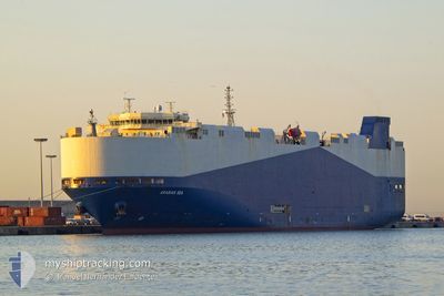
ARABIAN SEA
Vehicles Carrier
Current Trip
| Time Travelled | 1 day |
|---|---|
| Remaining Time | --- |
| Distance Travelled | 560.58 nm |
| Remaining Distance | --- |
| AVG Speed | 15.5 Knots |
| MAX Speed | 17.4 Knots |
| AVG Wind | 14.4 knots |
| MAX Wind | 20.3 knots |
| MIN Temp | 12.1°C / 53.78°F |
| MAX Temp | 14.9°C / 58.82°F |
| Draught | 9 m |
| Position Received | 17 h, 49 m ago |
Current Position
| Longitude | 129.59510° |
|---|---|
| Latitude | 34.96967° |
| Status | Under way using engine |
| Speed | 15.4 Knots |
| Course | 56.7° |
| Area | Japan Sea |
| Station | T-AIS |
| Position Received | 17 h, 49 m ago |
Info
Information
The current position of ARABIAN SEA is in Japan Sea with coordinates 34.96967° / 129.59510° as reported on 2024-04-23 18:22 by AIS to our vessel tracker app. The vessel's current speed is 15.4 Knots and is heading at the port of PUERTO QUETZAL. The estimated time of arrival as calculated by MyShipTracking vessel tracking app is 2024-05-12 22:00 LT
The vessel ARABIAN SEA (IMO: 9483786, MMSI: 538007767) is a Vehicles Carrier that was built in 2010 ( 14 years old ). It's sailing under the flag of [MH] Marshall Is.
In this page you can find informations about the vessels current position, last detected port calls, and current voyage information. If the vessels is not in coverage by AIS you will find the latest position.
The current position of ARABIAN SEA is detected by our AIS receivers and we are not responsible for the reliability of the data. The last position was recorded while the vessel was in Coverage by the Ais receivers of our vessel tracking app.
The current draught of ARABIAN SEA as reported by AIS is 9 meters
Weather
| Temperature | 13.7°C / 56.66°F |
|---|---|
| Wind Speed | 18 knots |
| Direction | 271° W |
| Pressure | 1006.3 hPa |
| Humidity | 78 % |
| Cloud Coverage | 88 % |
Featured Company
Last Port Calls
| Port | Arrival | Departure | Time In Port |
|---|---|---|---|
| 2024-04-21 17:23 | 2024-04-22 19:32 | 1 d | |
| 2024-04-20 14:05 | 2024-04-21 07:45 | 17 h | |
| 2024-03-30 08:08 | 2024-03-31 11:16 | 1 d | |
| 2024-03-28 16:02 | 2024-03-29 14:42 | 22 h | |
| 2024-03-19 18:08 | 2024-03-20 15:48 | 21 h | |
| 2024-02-29 09:42 | 2024-03-02 12:26 | 2 d | |
| 2024-02-28 01:49 | 2024-02-28 11:32 | 9 h | |
| 2024-02-26 01:02 | 2024-02-26 10:37 | 9 h | |
| 2024-02-23 22:26 | 2024-02-24 08:26 | 9 h | |
| 2024-02-23 02:16 | 2024-02-23 08:36 | 6 h |
Most Visited Ports (Last year)
| Port | Arrivals | |
|---|---|---|
| 4 | ||
| 3 | ||
| 3 | ||
| 3 | ||
| 3 | ||
| 3 |
Last Trips
| Origin | Departure | Destination | Arrival | Distance | |
|---|---|---|---|---|---|
| 2024-04-21 16:45 | 2024-04-22 02:23 | 120.45 nm | |||
| 2024-03-31 14:16 | 2024-04-20 23:05 | 6888.10 nm | |||
| 2024-03-29 17:42 | 2024-03-30 11:08 | 197.76 nm | |||
| 2024-03-20 19:48 | 2024-03-28 19:02 | 2985.05 nm | |||
| 2024-03-02 20:26 | 2024-03-19 22:08 | 5957.07 nm | |||
| 2024-02-28 20:32 | 2024-02-29 17:42 | 323.43 nm | |||
| 2024-02-26 19:37 | 2024-02-28 10:49 | 462.24 nm | |||
| 2024-02-24 17:26 | 2024-02-26 10:02 | 596.71 nm | |||
| 2024-02-23 17:36 | 2024-02-24 07:26 | 203.00 nm | |||
| 2024-02-22 19:42 | 2024-02-23 11:16 | 239.81 nm |
Events
| Time | Event | Details | Position / Dest | Info |
|---|---|---|---|---|
| 2024-04-23 18:29 | Status Changed | Default Under way using engine |
34.98521 / 129.62324
GT PRQ
|
Speed: 15.4 kn Course: 56.7° |
| 2024-04-23 18:22 | OUT of Coverage |
34.96967 / 129.59510
Japan Sea
GT PRQ
|
Speed: 15.4 kn Course: 56.7° |
|
| 2024-04-23 17:18 | Status Changed | Under way using engine Default |
34.79919 / 129.32202
GT PRQ
|
Speed: 16.1 kn Course: 48° |
| 2024-04-23 17:16 | Status Changed | Default Under way using engine |
34.79346 / 129.31442
GT PRQ
|
Speed: 16.3 kn Course: 46.7° |
| 2024-04-23 17:05 | Draught Changed | 9 8 |
34.76043 / 129.27132
GT PRQ
|
Speed: 16.5 kn Course: 48° |
| 2024-04-23 17:05 | Destination Changed | GT PRQ KR KUN |
34.76043 / 129.27132
GT PRQ
|
Speed: 16.5 kn Course: 48° |
| 2024-04-23 17:05 | ETA Changed | 2024/05/12 22:00 2024/04/21 16:00 |
34.76043 / 129.27132
GT PRQ
|
Speed: 16.5 kn Course: 48° |
| 2024-04-23 16:21 | Change Sea Area | Japanese part of the Japan Sea South Korean part of the Japan Sea |
34.62881 / 129.09274
Japan Sea
|
Speed: 15.9 kn Course: 65.5° |
| 2024-04-23 16:20 | Status Changed | Under way using engine Default |
34.62660 / 129.08688
KR KUN
|
Speed: 16.1 kn Course: 66° |
| 2024-04-23 16:08 | Status Changed | Default Under way using engine |
34.60435 / 129.02834
KR KUN
|
Speed: 16 kn Course: 60.8° |