
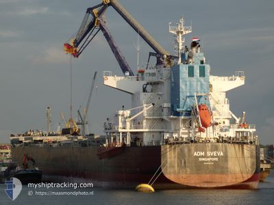
AOM SVEVA
Cargo
Current Trip
| Trip Time | 41 days |
|---|---|
| Trip Distance | 9780.08 nm |
| AVG Speed | 9.9 Knots |
| MAX Speed | 13 Knots |
| Draught | 12.8 m |
| AVG Wind | 12.5 knots |
| MAX Wind | 32 knots |
| MIN Temp | 15.7°C / 60.26°F |
| MAX Temp | 31°C / 87.8°F |
| Position Received | 12 h, 31 m ago |
Current Position
| Longitude | 107.02814° |
|---|---|
| Latitude | 10.58526° |
| Status | Under way using engine |
| Speed | |
| Course | 357° |
| Area | South China Sea |
| Station | T-AIS |
| Position Received | 12 h, 31 m ago |
Info
Information
The current position of AOM SVEVA is in South China Sea with coordinates 10.58526° / 107.02814° as reported on 2024-04-18 07:27 by AIS to our vessel tracker app. The vessel's current speed is 0 Knots and is currently inside the port of PHU MY.
The vessel AOM SVEVA (IMO: 9852793, MMSI: 563077500) is a Cargo It's sailing under the flag of [SG] Singapore.
In this page you can find informations about the vessels current position, last detected port calls, and current voyage information. If the vessels is not in coverage by AIS you will find the latest position.
The current position of AOM SVEVA is detected by our AIS receivers and we are not responsible for the reliability of the data. The last position was recorded while the vessel was in Coverage by the Ais receivers of our vessel tracking app.
The current draught of AOM SVEVA as reported by AIS is 12.8 meters
Weather
| Temperature | 28.4°C / 83.12°F |
|---|---|
| Wind Speed | 11 knots |
| Direction | 133° SE |
| Pressure | 1007.3 hPa |
| Humidity | 74.3 % |
| Cloud Coverage | 48 % |
Featured Company
Last Port Calls
| Port | Arrival | Departure | Time In Port |
|---|---|---|---|
| 2024-04-18 06:28 | |||
| 2024-03-04 00:53 | 2024-03-08 03:25 | 4 d |
Most Visited Ports (Last year)
| Port | Arrivals | |
|---|---|---|
| 2 | ||
| 2 | ||
| 1 | ||
| 1 | ||
| 1 | ||
| 1 |
Last Trips
| Origin | Departure | Destination | Arrival | Distance | |
|---|---|---|---|---|---|
| 2024-03-08 00:25 | 2024-04-18 13:28 | 9780.08 nm | |||
| 2024-01-15 21:11 | 2024-03-03 21:53 | 5314.62 nm |
Events
| Time | Event | Details | Position / Dest | Info |
|---|---|---|---|---|
| 2024-04-18 07:39 | Status Changed | Default Under way using engine |
10.58527 / 107.02813
[VN] PHU MY
|
Speed: Course: 357° |
| 2024-04-18 07:27 | STOP Moving |
10.58526 / 107.02814
[VN] PHU MY
|
Speed: Course: 357° |
|
| 2024-04-18 07:27 | OUT of Coverage |
10.58526 / 107.02814
South China Sea
[VN] PHU MY
|
Speed: Course: 75.4° |
|
| 2024-04-18 06:28 | PORT ARRIVAL |
|
10.57441 / 107.02188
[VN] PHU MY
|
Speed: 3.8 kn Course: 31° |
| 2024-04-18 05:12 | Detected in Sea | Vietnamese part of the South China Sea |
10.45569 / 106.99578
South China Sea
|
Speed: 8.2 kn Course: 344.1° |
| 2024-04-18 05:12 | Status Changed | Under way using engine Default |
10.45569 / 106.99578
VN PHU
|
Speed: 10.2 kn Course: 350° |
| 2024-04-18 05:12 | IN Coverage |
10.45569 / 106.99578
South China Sea
|
Speed: 8.2 kn Course: 344.1° |
|
| 2024-04-18 03:09 | START Moving | 8.6 nm, South of VUNG TAU |
10.26175 / 107.04449
VN PHU
|
Speed: 3.7 kn Course: 114° |
| 2024-04-17 07:28 | STOP Moving | 8.58 nm, South of VUNG TAU |
10.26303 / 107.04223
VN PHU
|
Speed: 0.1 kn Course: 295° |
| 2024-04-15 05:11 | OUT of Coverage |
1.28905 / 104.33024
Singapore Strait
VN PHU
|
Speed: 11.2 kn Course: 70.8° |