
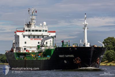
ANUKET SAPPHIRE
Oil/Chemical Tanker
Current Trip
GIGIB>SRPBM
| Time Travelled | 2 days |
|---|---|
| Remaining Time | --- |
| Distance Travelled | 196.31 nm |
| Remaining Distance | --- |
| AVG Speed | 8.4 Knots |
| MAX Speed | 11 Knots |
| AVG Wind | 13.5 knots |
| MAX Wind | 18 knots |
| MIN Temp | 25.1°C / 77.18°F |
| MAX Temp | 31.9°C / 89.42°F |
| Draught | 5.8 m |
| Position Received | 2024-03-06 10:58 |
Current Position
| Longitude | -16.90667° |
|---|---|
| Latitude | 27.62869° |
| Status | Under way using engine |
| Speed | 10.5 Knots |
| Course | 241.2° |
| Area | North Atlantic Ocean |
| Station | T-AIS |
| Position Received | 2024-03-06 10:58 |
Info
Information
The current position of ANUKET SAPPHIRE is in North Atlantic Ocean with coordinates 27.62869° / -16.90667° as reported on 2024-03-06 10:58 by AIS to our vessel tracker app. The vessel's current speed is 10.5 Knots
The vessel ANUKET SAPPHIRE (IMO: 9393670, MMSI: 351007000) is a Oil/Chemical Tanker that was built in 2008 ( 16 years old ). It's sailing under the flag of [PA] Panama.
In this page you can find informations about the vessels current position, last detected port calls, and current voyage information. If the vessels is not in coverage by AIS you will find the latest position.
The current position of ANUKET SAPPHIRE is detected by our AIS receivers and we are not responsible for the reliability of the data. The last position was recorded while the vessel was in Coverage by the Ais receivers of our vessel tracking app.
The current draught of ANUKET SAPPHIRE as reported by AIS is 5.8 meters
Weather
| Temperature | 27.3°C / 81.14°F |
|---|---|
| Wind Speed | 11 knots |
| Direction | 69° ENE |
| Pressure | 1011.6 hPa |
| Humidity | 76.4 % |
| Cloud Coverage | 100 % |
Featured Company
Last Port Calls
| Port | Arrival | Departure | Time In Port |
|---|---|---|---|
| 2024-04-21 18:06 | 2024-04-22 18:13 | 1 d | |
| 2024-04-19 05:15 | 2024-04-20 05:26 | 1 d | |
| 2024-04-10 08:55 | 2024-04-11 08:16 | 23 h | |
| 2024-04-05 16:59 | 2024-04-07 18:37 | 2 d | |
| 2024-04-03 15:11 | 2024-04-04 16:11 | 1 d | |
| 2024-03-27 00:01 | 2024-03-28 14:19 | 1 d | |
| 2024-03-22 06:07 | 2024-03-23 06:23 | 1 d | |
| 2024-03-19 03:37 | 2024-03-20 15:44 | 1 d | |
| 2024-03-18 02:43 | |||
| 2024-02-22 07:45 |
Most Visited Ports (Last year)
| Port | Arrivals | |
|---|---|---|
| 13 | ||
| 10 | ||
| 1 | ||
| 1 |
Last Trips
| Origin | Departure | Destination | Arrival | Distance | |
|---|---|---|---|---|---|
| 2024-04-20 02:26 | 2024-04-21 14:06 | 211.55 nm | |||
| 2024-04-11 05:16 | 2024-04-19 02:15 | 539.68 nm | |||
| 2024-04-07 14:37 | 2024-04-10 05:55 | 219.73 nm | |||
| 2024-04-04 13:11 | 2024-04-05 12:59 | 231.91 nm | |||
| 2024-03-28 10:19 | 2024-04-03 12:11 | 987.64 nm | |||
| 2024-03-23 03:23 | 2024-03-26 20:01 | 983.04 nm | |||
| 2024-03-20 11:44 | 2024-03-22 03:07 | 214.62 nm | |||
| 2024-03-17 23:43 | 2024-03-18 23:37 | 212.03 nm |
Events
| Time | Event | Details | Position / Dest | Info |
|---|---|---|---|---|
| 2024-04-24 17:26 | STOP Moving |
6.20167 / -55.23000
GIGIB>SRPBM
|
Speed: Course: -1° |
|
| 2024-04-23 19:22 | START Moving | 1.9 nm, North of GEORGETOWN |
6.82090 / -58.17075
GIGIB>SRPBM
|
Speed: 9 kn Course: 12° |
| 2024-04-22 18:13 | PORT DEPARTURE |
|
6.80833 / -58.17500
GIGIB>SRPBM
|
Speed: 2.8 kn Course: 225° |
| 2024-04-21 18:06 | STOP Moving |
6.82240 / -58.16705
[GY] GEORGETOWN
|
Speed: 0.1 kn Course: 31° |
|
| 2024-04-21 18:06 | PORT ARRIVAL |
|
6.82240 / -58.16705
[GY] GEORGETOWN
|
Speed: 1.6 kn Course: 48° |
| 2024-04-21 16:43 | START Moving | 13.31 nm, North East of GEORGETOWN |
6.95919 / -58.02920
GIGIB>SRPBM
|
Speed: 10.1 kn Course: 242° |
| 2024-04-20 22:58 | STOP Moving | 13.85 nm, North East of GEORGETOWN |
6.96167 / -58.01833
GIGIB>SRPBM
|
Speed: Course: -1° |
| 2024-04-20 05:26 | PORT DEPARTURE |
|
5.83967 / -55.09518
GIGIB>SRPBM
|
Speed: 7.2 kn Course: 33° |
| 2024-04-20 04:14 | START Moving |
5.76928 / -55.14646
[SR] PARAMARIBO
|
Speed: 3.4 kn Course: 326° |
|
| 2024-04-19 05:15 | PORT ARRIVAL |
|
5.76673 / -55.14545
[SR] PARAMARIBO
|
Speed: 9.8 kn Course: 247° |