
ANNE
Other Type
Current Trip
| Trip Time | 1 day |
|---|---|
| Trip Distance | 41.57 nm |
| AVG Speed | 6.7 Knots |
| MAX Speed | 9.5 Knots |
| Draught | 0 m |
| AVG Wind | 5.2 knots |
| MAX Wind | 16 knots |
| MIN Temp | 5.4°C / 41.72°F |
| MAX Temp | 9.7°C / 49.46°F |
| Position Received | 2 h, 33 m ago |
Current Position
| Longitude | 5.56380° |
|---|---|
| Latitude | 51.95465° |
| Status | Under way using engine |
| Speed | |
| Course | --- |
| Area | North Sea |
| Station | T-AIS |
| Position Received | 2 h, 33 m ago |
Info
Information
The current position of ANNE is in North Sea with coordinates 51.95465° / 5.56380° as reported on 2024-04-24 13:35 by AIS to our vessel tracker app. The vessel's current speed is 0 Knots and is currently inside the port of RHENEN.
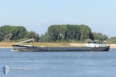
The vessel ANNE (MMSI: 244650162) is a Other Type It's sailing under the flag of [NL] Netherlands.
In this page you can find informations about the vessels current position, last detected port calls, and current voyage information. If the vessels is not in coverage by AIS you will find the latest position.
The current position of ANNE is detected by our AIS receivers and we are not responsible for the reliability of the data. The last position was recorded while the vessel was in Coverage by the Ais receivers of our vessel tracking app.
Weather
| Temperature | 8.7°C / 47.66°F |
|---|---|
| Wind Speed | 17 knots |
| Direction | 333° NNW |
| Pressure | 1008 hPa |
| Humidity | 71.4 % |
| Cloud Coverage | 98 % |
Featured Company
Last Port Calls
| Port | Arrival | Departure | Time In Port |
|---|---|---|---|
| 2024-04-24 11:50 | |||
| 2024-04-22 16:24 | 2024-04-23 07:06 | 14 h | |
| 2024-04-18 21:38 | 2024-04-22 08:24 | 3 d | |
| 2024-04-16 09:25 | 2024-04-17 12:34 | 1 d | |
| 2024-04-16 07:19 | 2024-04-16 08:56 | 1 h | |
| 2024-04-15 20:19 | 2024-04-16 07:06 | 10 h | |
| 2024-04-15 15:49 | 2024-04-15 16:10 | 20 m | |
| 2024-04-15 07:40 | 2024-04-15 08:02 | 22 m | |
| 2024-04-08 14:50 | 2024-04-08 19:53 | 5 h | |
| 2024-04-04 14:59 | 2024-04-05 05:17 | 14 h |
Most Visited Ports (Last year)
| Port | Arrivals | |
|---|---|---|
| 28 | ||
| 27 | ||
| 13 | ||
| 11 | ||
| 9 | ||
| 8 |
Last Trips
| Origin | Departure | Destination | Arrival | Distance | |
|---|---|---|---|---|---|
| 2024-04-23 09:06 | 2024-04-24 13:50 | 41.57 nm | |||
| 2024-04-22 10:24 | 2024-04-22 18:24 | 62.10 nm | |||
| 2024-04-17 14:34 | 2024-04-18 23:38 | 147.21 nm | |||
| 2024-04-16 10:56 | 2024-04-16 11:25 | 3.89 nm | |||
| 2024-04-16 09:06 | 2024-04-16 09:19 | 1.19 nm | |||
| 2024-04-15 18:10 | 2024-04-15 22:19 | 33.01 nm | |||
| 2024-04-15 10:02 | 2024-04-15 17:49 | 11.78 nm | |||
| 2024-04-08 21:53 | 2024-04-15 09:40 | 180.06 nm | |||
| 2024-04-05 07:17 | 2024-04-08 16:50 | 83.08 nm | |||
| 2024-04-03 08:46 | 2024-04-04 16:59 | 75.00 nm |
Events
| Time | Event | Details | Position / Dest | Info |
|---|---|---|---|---|
| 2024-04-24 13:35 | OUT of Coverage |
51.95465 / 5.56380
North Sea
[NL] RHENEN
|
Speed: Course: 0° |
|
| 2024-04-24 13:35 | IN Coverage |
51.95465 / 5.56380
North Sea
[NL] RHENEN
|
Speed: Course: 0° |
|
| 2024-04-24 11:50 | OUT of Coverage |
51.95470 / 5.56386
North Sea
[NL] RHENEN
|
Speed: Course: 64.5° |
|
| 2024-04-24 11:50 | STOP Moving |
51.95470 / 5.56386
[NL] RHENEN
|
Speed: Course: 511° |
|
| 2024-04-24 11:50 | PORT ARRIVAL |
|
51.95470 / 5.56386
[NL] RHENEN
|
Speed: 2.4 kn Course: 511° |
| 2024-04-24 11:24 | IN Coverage |
51.97810 / 5.50262
North Sea
|
Speed: 7.8 kn Course: 126.1° |
|
| 2024-04-24 09:23 | OUT of Coverage |
52.00607 / 5.18365
North Sea
|
Speed: 9.4 kn Course: 107.4° |
|
| 2024-04-24 09:05 | START Moving | 0.56 nm, North East of NIEUWEGEIN |
52.03105 / 5.12056
NWRKRK
|
Speed: 8.9 kn Course: 144.8° |
| 2024-04-23 11:26 | IN Coverage |
52.04655 / 5.10816
North Sea
|
Speed: Course: 0° |
|
| 2024-04-23 10:20 | OUT of Coverage |
52.05984 / 5.09780
North Sea
|
Speed: 5 kn Course: 151.6° |