
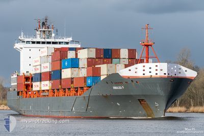
ANNALISA P
Container Ship
Current Trip
| Time Travelled | 2 days |
|---|---|
| Remaining Time | 5 h, 42 mins |
| Distance Travelled | 462.12 nm |
| Remaining Distance | 38.30 nm |
| AVG Speed | 7.7 Knots |
| MAX Speed | 7.7 Knots |
| AVG Wind | 10.8 knots |
| MAX Wind | 24.9 knots |
| MIN Temp | 1.7°C / 35.06°F |
| MAX Temp | 8.4°C / 47.12°F |
| Draught | 8.1 m |
| Position Received | Now |
Current Position
| Longitude | 9.17020° |
|---|---|
| Latitude | 53.90782° |
| Status | Under way using engine |
| Speed | 2.8 Knots |
| Course | 227° |
| Area | Baltic Sea |
| Station | T-AIS |
| Position Received | Now |
Info
Information
The current position of ANNALISA P is in Baltic Sea with coordinates 53.90782° / 9.17020° as reported on 2024-04-24 00:14 by AIS to our vessel tracker app. The vessel's current speed is 2.8 Knots and is heading at the port of HAMBURG. The estimated time of arrival as calculated by MyShipTracking vessel tracking app is 2024-04-24 05:57 LT
The vessel ANNALISA P (IMO: 9437141, MMSI: 305313000) is a Container Ship that was built in 2008 ( 16 years old ). It's sailing under the flag of [AG] Antigua Barbuda.
In this page you can find informations about the vessels current position, last detected port calls, and current voyage information. If the vessels is not in coverage by AIS you will find the latest position.
The current position of ANNALISA P is detected by our AIS receivers and we are not responsible for the reliability of the data. The last position was recorded while the vessel was in Coverage by the Ais receivers of our vessel tracking app.
The current draught of ANNALISA P as reported by AIS is 8.1 meters
Weather
| Temperature | 2.4°C / 36.32°F |
|---|---|
| Wind Speed | 5 knots |
| Direction | 223° SW |
| Pressure | 1006.7 hPa |
| Humidity | 90.9 % |
| Cloud Coverage | 100 % |
Featured Company
Last Port Calls
| Port | Arrival | Departure | Time In Port |
|---|---|---|---|
| 2024-04-21 02:25 | 2024-04-21 16:12 | 13 h | |
| 2024-04-20 04:25 | 2024-04-20 13:51 | 9 h | |
| 2024-04-16 12:03 | 2024-04-18 06:35 | 1 d | |
| 2024-04-13 11:19 | 2024-04-14 08:49 | 21 h | |
| 2024-04-12 10:56 | 2024-04-13 02:37 | 15 h | |
| 2024-04-11 02:09 | 2024-04-11 02:14 | 4 m | |
| 2024-04-08 19:25 | 2024-04-10 12:47 | 1 d | |
| 2024-04-06 05:11 | 2024-04-06 14:55 | 9 h | |
| 2024-04-05 12:18 | 2024-04-05 21:26 | 9 h | |
| 2024-04-02 11:41 | 2024-04-03 21:00 | 1 d |
Most Visited Ports (Last year)
| Port | Arrivals | |
|---|---|---|
| 44 | ||
| 43 | ||
| 41 | ||
| 28 | ||
| 8 |
Last Trips
| Origin | Departure | Destination | Arrival | Distance | |
|---|---|---|---|---|---|
| 2024-04-20 15:51 | 2024-04-21 05:25 | 118.45 nm | |||
| 2024-04-18 08:35 | 2024-04-20 06:25 | 445.96 nm | |||
| 2024-04-14 11:49 | 2024-04-16 14:03 | 505.77 nm | |||
| 2024-04-13 04:37 | 2024-04-13 14:19 | 117.27 nm | |||
| 2024-04-11 04:14 | 2024-04-12 12:56 | 355.47 nm | |||
| 2024-04-10 14:47 | 2024-04-11 04:09 | 88.62 nm | |||
| 2024-04-06 17:55 | 2024-04-08 21:25 | 500.69 nm | |||
| 2024-04-05 23:26 | 2024-04-06 08:11 | 115.89 nm | |||
| 2024-04-03 23:00 | 2024-04-05 14:18 | 444.70 nm | |||
| 2024-04-02 01:07 | 2024-04-02 13:41 | 88.95 nm |
Events
| Time | Event | Details | Position / Dest | Info |
|---|---|---|---|---|
| 2024-04-23 20:20 | START Moving | 6.84 nm, North East of FISCHERHUTTE |
54.19930 / 9.55154
DEHAM VIA NOK
|
Speed: 3.2 kn Course: 231° |
| 2024-04-23 19:55 | STOP Moving | 7 nm, North East of FISCHERHUTTE |
54.20071 / 9.55528
DEHAM VIA NOK
|
Speed: 0.3 kn Course: 238° |
| 2024-04-23 19:03 | START Moving | 4.2 nm, South West of RENDSBURG |
54.25936 / 9.62162
DEHAM VIA NOK
|
Speed: 3.1 kn Course: 201° |
| 2024-04-23 18:28 | STOP Moving | 3.79 nm, South West of RENDSBURG |
54.26618 / 9.62630
DEHAM VIA NOK
|
Speed: 0.3 kn Course: 208° |
| 2024-04-23 15:57 | START Moving | 7.28 nm, West of KIEL |
54.34189 / 9.95295
DEHAM VIA NOK
|
Speed: 3.8 kn Course: 252° |
| 2024-04-23 15:50 | STOP Moving | 7.17 nm, West of KIEL |
54.34203 / 9.95614
DEHAM VIA NOK
|
Speed: 0.3 kn Course: 263° |
| 2024-04-23 14:38 | START Moving | 1.44 nm, South West of STICKENHΟRN SPORT |
54.36597 / 10.13895
DEHAM VIA NOK
|
Speed: 3.2 kn Course: 282° |
| 2024-04-23 14:13 | STOP Moving | 1.38 nm, South West of STICKENHΟRN SPORT |
54.36555 / 10.14203
DEHAM VIA NOK
|
Speed: 0.2 kn Course: 282° |
| 2024-04-23 12:22 | START Moving | 8.95 nm, North East of WENDTORF |
54.54592 / 10.41292
DEHAM VIA NOK
|
Speed: 3.1 kn Course: 226° |
| 2024-04-23 12:03 | Status Changed | Under way using engine At anchor |
54.54898 / 10.42068
DEHAM VIA NOK
|
Speed: 0.7 kn Course: 271° |