
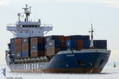
ANNABELLA
Container Ship
Current Trip
| Time Travelled | 8 days |
|---|---|
| Remaining Time | --- |
| Distance Travelled | 1133.31 nm |
| Remaining Distance | --- |
| AVG Speed | 12.1 Knots |
| MAX Speed | 14.4 Knots |
| AVG Wind | 12.3 knots |
| MAX Wind | 25.9 knots |
| MIN Temp | 11.9°C / 53.42°F |
| MAX Temp | 21.7°C / 71.06°F |
| Draught | 5.2 m |
| Position Received | 7 h, 24 m ago |
Current Position
| Longitude | 21.36050° |
|---|---|
| Latitude | 37.37751° |
| Status | Under way using engine |
| Speed | 11.9 Knots |
| Course | 157.3° |
| Area | Ionian Sea |
| Station | T-AIS |
| Position Received | 7 h, 24 m ago |
Info
Information
The current position of ANNABELLA is in Ionian Sea with coordinates 37.37751° / 21.36050° as reported on 2024-04-24 09:09 by AIS to our vessel tracker app. The vessel's current speed is 11.9 Knots and is heading at the port of ISTANBUL. The estimated time of arrival as calculated by MyShipTracking vessel tracking app is 2024-04-24 17:00 LT
The vessel ANNABELLA (IMO: 8919788, MMSI: 620743000) is a Container Ship that was built in 1991 ( 33 years old ). It's sailing under the flag of [KM] Comoros.
In this page you can find informations about the vessels current position, last detected port calls, and current voyage information. If the vessels is not in coverage by AIS you will find the latest position.
The current position of ANNABELLA is detected by our AIS receivers and we are not responsible for the reliability of the data. The last position was recorded while the vessel was in Coverage by the Ais receivers of our vessel tracking app.
The current draught of ANNABELLA as reported by AIS is 5.2 meters
Weather
| Temperature | 16.7°C / 62.06°F |
|---|---|
| Wind Speed | 24 knots |
| Direction | 285° WNW |
| Pressure | 1007.5 hPa |
| Humidity | 72.7 % |
| Cloud Coverage | 100 % |
Featured Company
Last Trips
| Origin | Departure | Destination | Arrival | Distance | |
|---|---|---|---|---|---|
| 2024-04-02 09:54 | 2024-04-10 16:40 | 1601.99 nm | |||
| 2024-03-31 10:13 | 2024-04-02 08:24 | 349.95 nm | |||
| 2024-03-14 19:07 | 2024-03-27 16:05 | 474.70 nm | |||
| 2024-02-27 07:52 | 2024-03-06 15:49 | 440.00 nm | |||
| 2024-01-23 07:44 | 2024-02-18 14:49 | 1687.40 nm |
Events
| Time | Event | Details | Position / Dest | Info |
|---|---|---|---|---|
| 2024-04-24 09:30 | Status Changed | Default Under way using engine |
37.31358 / 21.38899
TRIST
|
Speed: 11.9 kn Course: 157.3° |
| 2024-04-24 09:09 | OUT of Coverage |
37.37751 / 21.36050
Ionian Sea
TRIST
|
Speed: 11.9 kn Course: 157.3° |
|
| 2024-04-24 05:27 | START Moving | 1.97 nm, North of ALIKANAS |
37.87605 / 20.78161
TRIST
|
Speed: 3.4 kn Course: 61° |
| 2024-04-23 10:19 | Status Changed | Under way using engine Default |
37.87423 / 20.77833
TRIST
|
Speed: Course: 123° |
| 2024-04-23 10:15 | Status Changed | Default Under way using engine |
37.87390 / 20.77829
TRIST
|
Speed: 0.5 kn Course: 104° |
| 2024-04-22 11:06 | STOP Moving | 1.86 nm, North of ALIKANAS |
37.87424 / 20.78173
TRIST
|
Speed: Course: 195° |
| 2024-04-22 03:47 | Detected in Sea | Greek part of the Ionian Sea |
37.88113 / 18.99958
Ionian Sea
TRIST
|
Speed: 12.6 kn Course: 88° |
| 2024-04-22 03:47 | IN Coverage |
37.88113 / 18.99958
Ionian Sea
TRIST
|
Speed: 12.6 kn Course: 88° |
|
| 2024-04-21 16:36 | Status Changed | Default Under way using engine |
37.86660 / 16.02950
TRIST
|
Speed: 12.5 kn Course: 91.8° |
| 2024-04-21 16:04 | OUT of Coverage |
37.86873 / 15.89235
Ionian Sea
TRIST
|
Speed: 12.5 kn Course: 91.8° |