
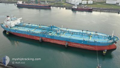
AMAX ANTHEM
Crude Oil Tanker
Current Trip
| Time Travelled | 2 days |
|---|---|
| Remaining Time | --- |
| Distance Travelled | 593.29 nm |
| Remaining Distance | --- |
| AVG Speed | 11.2 Knots |
| MAX Speed | 13.9 Knots |
| AVG Wind | 7.2 knots |
| MAX Wind | 14.6 knots |
| MIN Temp | 15.6°C / 60.08°F |
| MAX Temp | 28.9°C / 84.02°F |
| Draught | 8.1 m |
| Position Received | 13 h, 56 m ago |
Current Position
| Longitude | -12.74770° |
|---|---|
| Latitude | 36.56329° |
| Status | Under way using engine |
| Speed | 13.6 Knots |
| Course | 279.1° |
| Area | North Atlantic Ocean |
| Station | T-AIS |
| Position Received | 13 h, 56 m ago |
Info
Information
The current position of AMAX ANTHEM is in North Atlantic Ocean with coordinates 36.56329° / -12.74770° as reported on 2024-04-18 11:50 by AIS to our vessel tracker app. The vessel's current speed is 13.6 Knots and is heading at the port of HOUSTON. The estimated time of arrival as calculated by MyShipTracking vessel tracking app is 2024-05-02 15:00 LT
The vessel AMAX ANTHEM (IMO: 9472634, MMSI: 538006199) is a Crude Oil Tanker that was built in 2011 ( 13 years old ). It's sailing under the flag of [MH] Marshall Is.
In this page you can find informations about the vessels current position, last detected port calls, and current voyage information. If the vessels is not in coverage by AIS you will find the latest position.
The current position of AMAX ANTHEM is detected by our AIS receivers and we are not responsible for the reliability of the data. The last position was recorded while the vessel was in Coverage by the Ais receivers of our vessel tracking app.
The current draught of AMAX ANTHEM as reported by AIS is 8.1 meters
Weather
| Temperature | 15.8°C / 60.44°F |
|---|---|
| Wind Speed | 6 knots |
| Direction | 307° NW |
| Pressure | 1016.1 hPa |
| Humidity | 70.7 % |
| Cloud Coverage | 100 % |
Featured Company
Last Port Calls
| Port | Arrival | Departure | Time In Port |
|---|---|---|---|
| 2024-04-13 20:53 | 2024-04-16 07:49 | 2 d | |
| 2024-04-05 08:54 | 2024-04-07 11:21 | 2 d | |
| 2024-03-30 22:10 | 2024-04-02 15:05 | 2 d | |
| 2024-03-27 10:09 | 2024-03-28 10:41 | 1 d | |
| 2024-03-07 04:34 | 2024-03-11 14:27 | 4 d | |
| 2024-02-02 14:18 | 2024-02-03 23:35 | 1 d |
Last Trips
| Origin | Departure | Destination | Arrival | Distance | |
|---|---|---|---|---|---|
| 2024-04-07 11:21 | 2024-04-13 20:53 | 575.38 nm | |||
| 2024-04-02 16:05 | 2024-04-05 08:54 | 467.98 nm | |||
| 2024-03-28 10:41 | 2024-03-30 22:10 | 10.63 nm | |||
| 2024-03-11 09:27 | 2024-03-27 10:09 | 4624.43 nm | |||
| 2024-02-04 00:35 | 2024-03-06 22:34 | 7156.25 nm | |||
| 2024-01-28 17:42 | 2024-02-02 15:18 | 1448.12 nm |
Events
| Time | Event | Details | Position / Dest | Info |
|---|---|---|---|---|
| 2024-04-18 11:57 | Status Changed | Default Under way using engine |
36.56695 / -12.78053
US HOU
|
Speed: 13.6 kn Course: 279.1° |
| 2024-04-18 11:50 | Status Changed | Under way using engine Default |
36.56329 / -12.74770
US HOU
|
Speed: 13 kn Course: 277° |
| 2024-04-18 11:50 | OUT of Coverage |
36.56329 / -12.74770
North Atlantic Ocean
US HOU
|
Speed: 13.6 kn Course: 279.1° |
|
| 2024-04-18 11:42 | Status Changed | Default Under way using engine |
36.55833 / -12.71333
US HOU
|
Speed: 13.4 kn Course: 275.5° |
| 2024-04-18 11:24 | Status Changed | Under way using engine Default |
36.54959 / -12.62688
US HOU
|
Speed: 13 kn Course: 276° |
| 2024-04-18 10:38 | Status Changed | Default Under way using engine |
36.52244 / -12.41922
US HOU
|
Speed: 13.3 kn Course: 279.4° |
| 2024-04-18 10:16 | Status Changed | Under way using engine Default |
36.50941 / -12.31887
US HOU
|
Speed: 13 kn Course: 284° |
| 2024-04-18 09:57 | IN Coverage |
36.50941 / -12.31887
North Atlantic Ocean
US HOU
|
Speed: 13.2 kn Course: 283.8° |
|
| 2024-04-18 08:13 | Status Changed | Default Under way using engine |
36.44341 / -11.76097
US HOU
|
Speed: 13 kn Course: 277.5° |
| 2024-04-18 07:56 | OUT of Coverage |
36.43494 / -11.68283
North Atlantic Ocean
US HOU
|
Speed: 13 kn Course: 277.5° |