
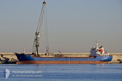
ALTAY
Bulk Carrier
Current Trip
| Time Travelled | 4 days |
|---|---|
| Remaining Time | --- |
| Distance Travelled | 234.64 nm |
| Remaining Distance | --- |
| AVG Speed | 8 Knots |
| MAX Speed | 10.1 Knots |
| AVG Wind | 12 knots |
| MAX Wind | 32.7 knots |
| MIN Temp | 4.6°C / 40.28°F |
| MAX Temp | 15°C / 59°F |
| Draught | 4.1 m |
| Position Received | 5 h, 1 m ago |
Current Position
| Longitude | 6.79798° |
|---|---|
| Latitude | 43.13687° |
| Status | Under way using engine |
| Speed | 9.1 Knots |
| Course | 234° |
| Area | Mediterranean Sea - Western Basin |
| Station | T-AIS |
| Position Received | 5 h, 1 m ago |
Info
Information
The current position of ALTAY is in Mediterranean Sea - Western Basin with coordinates 43.13687° / 6.79798° as reported on 2024-04-24 19:34 by AIS to our vessel tracker app. The vessel's current speed is 9.1 Knots and is heading at the port of TENES. The estimated time of arrival as calculated by MyShipTracking vessel tracking app is 2024-04-27 07:00 LT
The vessel ALTAY (IMO: 9349992, MMSI: 538004502) is a Bulk Carrier that was built in 2006 ( 18 years old ). It's sailing under the flag of [MH] Marshall Is.
In this page you can find informations about the vessels current position, last detected port calls, and current voyage information. If the vessels is not in coverage by AIS you will find the latest position.
The current position of ALTAY is detected by our AIS receivers and we are not responsible for the reliability of the data. The last position was recorded while the vessel was in Coverage by the Ais receivers of our vessel tracking app.
The current draught of ALTAY as reported by AIS is 4.1 meters
Weather
| Temperature | 12.6°C / 54.68°F |
|---|---|
| Wind Speed | 23 knots |
| Direction | 306° NW |
| Pressure | 1006.8 hPa |
| Humidity | 45.9 % |
| Cloud Coverage | --- |
Featured Company
Last Port Calls
| Port | Arrival | Departure | Time In Port |
|---|---|---|---|
| 2024-04-19 11:57 | 2024-04-20 23:46 | 1 d | |
| 2024-04-14 05:57 | 2024-04-16 02:20 | 1 d | |
| 2024-04-09 00:20 | 2024-04-09 11:16 | 10 h | |
| 2024-04-06 12:33 | 2024-04-08 12:01 | 1 d | |
| 2024-03-27 10:21 | 2024-03-29 06:46 | 1 d | |
| 2024-03-26 02:00 | |||
| 2024-03-18 14:46 | 2024-03-19 23:16 | 1 d | |
| 2024-03-14 17:04 | |||
| 2024-03-11 20:18 | |||
| 2024-02-29 13:15 | 2024-02-29 13:21 | 6 m |
Last Trips
| Origin | Departure | Destination | Arrival | Distance | |
|---|---|---|---|---|---|
| 2024-04-16 03:20 | 2024-04-19 13:57 | 505.75 nm | |||
| 2024-04-09 13:16 | 2024-04-14 06:57 | 465.89 nm | |||
| 2024-04-08 14:01 | 2024-04-09 02:20 | 110.56 nm | |||
| 2024-03-29 09:46 | 2024-04-06 14:33 | 1544.60 nm | |||
| 2024-03-26 04:00 | 2024-03-27 13:21 | 180.57 nm | |||
| 2024-03-11 23:18 | 2024-03-14 21:04 | 252.96 nm | |||
| 2024-02-28 15:45 | 2024-02-29 15:15 | 68.17 nm | |||
| 2024-02-21 06:59 | 2024-02-23 15:47 | 60.58 nm | |||
| 2024-02-15 12:03 | 2024-02-20 15:06 | 1035.29 nm | |||
| 2024-02-04 03:21 | 2024-02-12 17:57 | 546.16 nm |
Events
| Time | Event | Details | Position / Dest | Info |
|---|---|---|---|---|
| 2024-04-24 19:37 | Status Changed | Default Under way using engine |
43.13167 / 6.78833
TENES
|
Speed: 9.1 kn Course: 234° |
| 2024-04-24 19:34 | OUT of Coverage |
43.13687 / 6.79798
Mediterranean Sea - Western Basin
TENES
|
Speed: 9.1 kn Course: 234° |
|
| 2024-04-24 15:26 | Change Sea Area | French part of the Mediterranean Sea - Western Basin Mon�gasque part of the Mediterranean Sea - Western Basin |
43.54448 / 7.48988
Mediterranean Sea - Western Basin
TENES
|
Speed: 9.9 kn Course: 234° |
| 2024-04-24 15:17 | Change Sea Area | Mon�gasque part of the Mediterranean Sea - Western Basin French part of the Mediterranean Sea - Western Basin |
43.56032 / 7.51624
Mediterranean Sea - Western Basin
TENES
|
Speed: 9.9 kn Course: 228.3° |
| 2024-04-24 14:44 | Change Sea Area | French part of the Mediterranean Sea - Western Basin Italian part of the Mediterranean Sea - Western Basin |
43.61570 / 7.61342
Mediterranean Sea - Western Basin
TENES
|
Speed: 9.7 kn Course: 230.4° |
| 2024-04-24 13:59 | Detected in Sea | Italian part of the Mediterranean Sea - Western Basin |
43.69214 / 7.74660
Mediterranean Sea - Western Basin
TENES
|
Speed: 9.5 kn Course: 237.4° |
| 2024-04-24 13:03 | Destination Changed | TENES ANNABA |
43.77734 / 7.89567
TENES
|
Speed: 8.4 kn Course: 234.2° |
| 2024-04-24 13:03 | ETA Changed | 2024/04/27 07:00 2024/04/23 21:00 |
43.77734 / 7.89567
TENES
|
Speed: 8.4 kn Course: 234.2° |
| 2024-04-24 12:34 | Status Changed | Under way using engine Default |
43.81517 / 7.97183
ANNABA
|
Speed: 8.3 kn Course: 236° |
| 2024-04-24 12:24 | IN Coverage |
43.81471 / 7.97086
Ligurian Sea
|
Speed: 8.2 kn Course: 235.7° |