
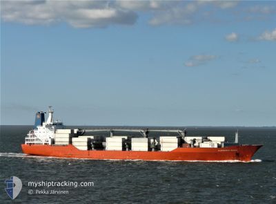
ALBEMARLE ISLAND
Reefer
Current Trip
| Trip Time | 8 days |
|---|---|
| Trip Distance | 2314.17 nm |
| AVG Speed | 13.1 Knots |
| MAX Speed | 13.1 Knots |
| Draught | 7.3 m |
| AVG Wind | 8.8 knots |
| MAX Wind | 19.4 knots |
| MIN Temp | 23.8°C / 74.84°F |
| MAX Temp | 35.8°C / 96.44°F |
| Position Received | 4 d ago |
Current Position
| Longitude | -79.46224° |
|---|---|
| Latitude | 8.47589° |
| Status | Under way using engine |
| Speed | 18 Knots |
| Course | 181° |
| Area | North Pacific Ocean |
| Station | T-AIS |
| Position Received | 4 d ago |
Info
Information
The current position of ALBEMARLE ISLAND is in North Pacific Ocean with coordinates 8.47589° / -79.46224° as reported on 2024-04-20 21:57 by AIS to our vessel tracker app. The vessel's current speed is 18 Knots and is currently inside the port of PUERTO BOLIVAR.
The vessel ALBEMARLE ISLAND (IMO: 9059602, MMSI: 308511000) is a Reefer that was built in 1993 ( 31 years old ). It's sailing under the flag of [BS] Bahamas.
In this page you can find informations about the vessels current position, last detected port calls, and current voyage information. If the vessels is not in coverage by AIS you will find the latest position.
The current position of ALBEMARLE ISLAND is detected by our AIS receivers and we are not responsible for the reliability of the data. The last position was recorded while the vessel was in Coverage by the Ais receivers of our vessel tracking app.
The current draught of ALBEMARLE ISLAND as reported by AIS is 7.3 meters
Weather
| Temperature | 24.7°C / 76.46°F |
|---|---|
| Wind Speed | 3 knots |
| Direction | 229° SW |
| Pressure | 1012.9 hPa |
| Humidity | 89.2 % |
| Cloud Coverage | 100 % |
Featured Company
Last Port Calls
| Port | Arrival | Departure | Time In Port |
|---|---|---|---|
| 2024-04-23 13:46 | |||
| 2024-04-15 01:06 | |||
| 2024-04-11 21:52 | 2024-04-13 09:56 | 1 d | |
| 2024-04-09 08:45 | 2024-04-09 18:22 | 9 h | |
| 2024-04-08 07:23 | 2024-04-08 17:20 | 9 h | |
| 2024-03-29 11:25 | 2024-03-29 21:35 | 10 h | |
| 2024-03-26 02:55 | 2024-03-28 16:56 | 2 d | |
| 2024-03-25 07:44 | 2024-03-25 17:45 | 10 h | |
| 2024-02-29 03:39 | 2024-02-29 07:37 | 3 h | |
| 2024-02-23 19:37 |
Most Visited Ports (Last year)
| Port | Arrivals | |
|---|---|---|
| 10 | ||
| 5 | ||
| 5 | ||
| 5 | ||
| 5 | ||
| 4 |
Last Trips
| Origin | Departure | Destination | Arrival | Distance | |
|---|---|---|---|---|---|
| 2024-04-14 21:06 | 2024-04-23 08:46 | 2314.17 nm | |||
| 2024-04-09 14:22 | 2024-04-11 18:52 | 646.68 nm | |||
| 2024-04-08 13:20 | 2024-04-09 04:45 | 119.22 nm | |||
| 2024-03-29 22:35 | 2024-04-08 03:23 | 3654.88 nm | |||
| 2024-03-28 17:56 | 2024-03-29 12:25 | 256.72 nm | |||
| 2024-03-25 17:45 | 2024-03-26 03:55 | 95.76 nm | |||
| 2024-02-29 02:37 | 2024-03-25 07:44 | 7166.71 nm | |||
| 2024-02-22 03:15 | 2024-02-23 16:37 | 643.71 nm | |||
| 2024-02-20 18:30 | 2024-02-21 20:41 | 11.14 nm | |||
| 2024-02-09 20:19 | 2024-02-20 06:15 | 3831.60 nm |
Events
| Time | Event | Details | Position / Dest | Info |
|---|---|---|---|---|
| 2024-04-23 13:46 | PORT ARRIVAL |
|
-3.25719 / -80.00171
[EC] PUERTO BOLIVAR
|
Speed: 2 kn Course: 112° |
| 2024-04-22 18:14 | STOP Moving | 5.15 nm, North West of PUERTO BOLIVAR |
-3.18318 / -80.04552
PACTB!LMA
|
Speed: Course: 249° |
| 2024-04-20 22:01 | Status Changed | Default Under way using engine |
8.46029 / -79.46247
PACTB!LMA
|
Speed: 18 kn Course: 181° |
| 2024-04-20 21:57 | Status Changed | Under way using engine Default |
8.47589 / -79.46224
PACTB!LMA
|
Speed: 18.6 kn Course: 181° |
| 2024-04-20 21:57 | OUT of Coverage |
8.47589 / -79.46224
North Pacific Ocean
PACTB!LMA
|
Speed: 18 kn Course: 181° |
|
| 2024-04-20 21:52 | Status Changed | Default Under way using engine |
8.50188 / -79.46179
PACTB!LMA
|
Speed: 18.6 kn Course: 180.6° |
| 2024-04-20 20:17 | Change Sea Area | Panamanian part of the North Pacific Ocean Panamanian part of the Caribbean Sea |
8.90802 / -79.53741
North Pacific Ocean
PACTB!LMA
|
Speed: 9.9 kn Course: 140.7° |
| 2024-04-20 19:33 | START Moving | 2.38 nm, North of RODMAN |
8.99298 / -79.58756
PACTB!LMA
|
Speed: 4 kn Course: 135° |
| 2024-04-20 18:23 | STOP Moving | 3.1 nm, North West of RODMAN |
9.00213 / -79.59669
PACTB!LMA
|
Speed: 0.3 kn Course: 136° |
| 2024-04-20 18:02 | START Moving | 3.89 nm, North West of RODMAN |
9.01180 / -79.60660
PACTB!LMA
|
Speed: 4.3 kn Course: 129° |