
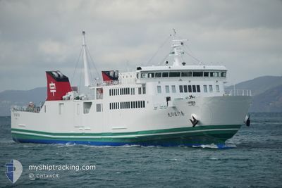
AKEBONO MARU
Passenger
Current Trip
| Time Travelled | 1 h, 53 mins |
|---|---|
| Remaining Time | 3 h, 24 mins |
| Distance Travelled | 29.01 nm |
| Remaining Distance | --- |
| AVG Speed | 17.2 Knots |
| MAX Speed | 18.1 Knots |
| AVG Wind | 5.1 knots |
| MAX Wind | 6.8 knots |
| MIN Temp | 16.1°C / 60.98°F |
| MAX Temp | 17.4°C / 63.32°F |
| Draught | 4.5 m |
| Position Received | 2023-02-13 05:29 |
Current Position
| Longitude | 132.31259° |
|---|---|
| Latitude | 33.42507° |
| Status | Under way using engine |
| Speed | 17 Knots |
| Course | 54.1° |
| Area | Philippine Sea |
| Station | T-AIS |
| Position Received | 2023-02-13 05:29 |
Info
Information
The current position of AKEBONO MARU is in Philippine Sea with coordinates 33.42507° / 132.31259° as reported on 2023-02-13 05:29 by AIS to our vessel tracker app. The vessel's current speed is 17 Knots and is heading at the port of USUKI. The estimated time of arrival as calculated by MyShipTracking vessel tracking app is 2024-04-23 14:55 LT
The vessel AKEBONO MARU (IMO: 9832353, MMSI: 431010539) is a Passenger It's sailing under the flag of [JP] Japan.
In this page you can find informations about the vessels current position, last detected port calls, and current voyage information. If the vessels is not in coverage by AIS you will find the latest position.
The current position of AKEBONO MARU is detected by our AIS receivers and we are not responsible for the reliability of the data. The last position was recorded while the vessel was in Coverage by the Ais receivers of our vessel tracking app.
The current draught of AKEBONO MARU as reported by AIS is 4.5 meters
Weather
| Temperature | 16.4°C / 61.52°F |
|---|---|
| Wind Speed | 7 knots |
| Direction | 28° NNE |
| Pressure | 1007.5 hPa |
| Humidity | 95.4 % |
| Cloud Coverage | 100 % |
Featured Company
Last Port Calls
| Port | Arrival | Departure | Time In Port |
|---|---|---|---|
| 2024-04-23 08:50 | 2024-04-23 09:38 | 47 m | |
| 2024-04-23 05:51 | 2024-04-23 06:41 | 50 m | |
| 2024-04-23 02:50 | 2024-04-23 03:45 | 55 m | |
| 2024-04-22 23:59 | 2024-04-23 00:50 | 50 m | |
| 2024-04-22 18:04 | 2024-04-22 18:24 | 19 m | |
| 2024-04-22 15:11 | 2024-04-22 16:04 | 52 m | |
| 2024-04-22 11:50 | 2024-04-22 13:08 | 1 h | |
| 2024-04-22 08:47 | 2024-04-22 09:36 | 49 m | |
| 2024-04-22 05:55 | 2024-04-22 06:48 | 52 m | |
| 2024-04-22 02:52 | 2024-04-22 03:56 | 1 h |
Most Visited Ports (Last year)
| Port | Arrivals | |
|---|---|---|
| 1235 | ||
| 1051 | ||
| 30 |
Last Trips
| Origin | Departure | Destination | Arrival | Distance | |
|---|---|---|---|---|---|
| 2024-04-23 15:41 | 2024-04-23 17:50 | 35.41 nm | |||
| 2024-04-23 12:45 | 2024-04-23 14:51 | 34.19 nm | |||
| 2024-04-23 09:50 | 2024-04-23 11:50 | 32.49 nm | |||
| 2024-04-23 03:24 | 2024-04-23 08:59 | 1.23 nm | |||
| 2024-04-23 01:04 | 2024-04-23 03:04 | 33.48 nm | |||
| 2024-04-22 22:08 | 2024-04-23 00:11 | 35.78 nm | |||
| 2024-04-22 18:36 | 2024-04-22 20:50 | 35.98 nm | |||
| 2024-04-22 15:48 | 2024-04-22 17:47 | 34.53 nm | |||
| 2024-04-22 12:56 | 2024-04-22 14:55 | 33.03 nm | |||
| 2024-04-22 09:50 | 2024-04-22 11:52 | 35.56 nm |
Events
| Time | Event | Details | Position / Dest | Info |
|---|---|---|---|---|
| 2024-04-23 09:38 | START Moving | 0.76 nm, North East of USUKI |
33.13500 / 131.82666
JP USK
|
Speed: 12 kn Course: -1° |
| 2024-04-23 09:38 | PORT DEPARTURE |
|
33.13500 / 131.82666
JP USK
|
Speed: Course: 103° |
| 2024-04-23 08:50 | STOP Moving |
33.12500 / 131.81166
[JP] USUKI
|
Speed: Course: -1° |
|
| 2024-04-23 08:50 | PORT ARRIVAL |
|
33.12500 / 131.81166
[JP] USUKI
|
Speed: 9 kn Course: 226° |
| 2024-04-23 06:45 | START Moving | 1.06 nm, South of KAWANOISHI |
33.45334 / 132.39352
JP USK
|
Speed: 17 kn Course: 259° |
| 2024-04-23 06:41 | PORT DEPARTURE |
|
33.45334 / 132.39352
JP USK
|
Speed: Course: -1° |
| 2024-04-23 06:20 | STOP Moving |
33.45667 / 132.41333
[JP] YAWATAHAMA
|
Speed: Course: -1° |
|
| 2024-04-23 05:51 | PORT ARRIVAL |
|
33.45667 / 132.41333
[JP] YAWATAHAMA
|
Speed: 12.7 kn Course: 81° |
| 2024-04-23 03:53 | START Moving | 2.05 nm, North East of USUKI |
33.14667 / 131.84833
JP USK
|
Speed: 17 kn Course: -1° |
| 2024-04-23 03:45 | PORT DEPARTURE |
|
33.14667 / 131.84833
JP USK
|
Speed: Course: 103° |