
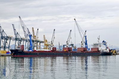
ADELINA
Bulk Carrier
Current Trip
| Time Travelled | 44 days |
|---|---|
| Remaining Time | 17 h, 6 mins |
| Distance Travelled | 11728.78 nm |
| Remaining Distance | 191.61 nm |
| AVG Speed | 10.5 Knots |
| MAX Speed | 15 Knots |
| AVG Wind | 13.7 knots |
| MAX Wind | 32.4 knots |
| MIN Temp | 4.5°C / 40.1°F |
| MAX Temp | 29.8°C / 85.64°F |
| Draught | 8.9 m |
| Position Received | 1 m ago |
Current Position
| Longitude | 14.20086° |
|---|---|
| Latitude | 54.63590° |
| Status | Under way using engine |
| Speed | 10.6 Knots |
| Course | 109.5° |
| Area | Baltic Sea |
| Station | T-AIS |
| Position Received | 1 m ago |
Info
Information
The current position of ADELINA is in Baltic Sea with coordinates 54.63590° / 14.20086° as reported on 2024-04-25 19:01 by AIS to our vessel tracker app. The vessel's current speed is 10.6 Knots and is heading at the port of GDYNIA. The estimated time of arrival as calculated by MyShipTracking vessel tracking app is 2024-04-26 12:08 LT
The vessel ADELINA (IMO: 9595785, MMSI: 215521000) is a Bulk Carrier that was built in 2012 ( 12 years old ). It's sailing under the flag of [MT] Malta.
In this page you can find informations about the vessels current position, last detected port calls, and current voyage information. If the vessels is not in coverage by AIS you will find the latest position.
The current position of ADELINA is detected by our AIS receivers and we are not responsible for the reliability of the data. The last position was recorded while the vessel was in Coverage by the Ais receivers of our vessel tracking app.
The current draught of ADELINA as reported by AIS is 8.9 meters
Weather
| Temperature | 4.8°C / 40.64°F |
|---|---|
| Wind Speed | 16 knots |
| Direction | 116° ESE |
| Pressure | 1005.4 hPa |
| Humidity | 82.1 % |
| Cloud Coverage | 100 % |
Featured Company
Events
| Time | Event | Details | Position / Dest | Info |
|---|---|---|---|---|
| 2024-04-25 16:19 | Status Changed | Under way using engine Default |
54.80212 / 13.40353
GDYNIA
|
Speed: 11.3 kn Course: 110° |
| 2024-04-25 16:16 | Status Changed | Default Under way using engine |
54.80466 / 13.39173
GDYNIA
|
Speed: 11.3 kn Course: 109.6° |
| 2024-04-25 12:40 | Change Sea Area | German part of the Baltic Sea Danish part of the Baltic Sea |
54.59245 / 12.33157
Baltic Sea
GDYNIA
|
Speed: 11 kn Course: 55.9° |
| 2024-04-25 12:32 | Change Sea Area | Danish part of the Baltic Sea German part of the Baltic Sea |
54.57489 / 12.30466
Baltic Sea
GDYNIA
|
Speed: 11.6 kn Course: 18.8° |
| 2024-04-25 11:20 | Change Sea Area | German part of the Baltic Sea Danish part of the Baltic Sea |
54.40673 / 12.10443
Baltic Sea
GDYNIA
|
Speed: 10.7 kn Course: 82.4° |
| 2024-04-25 09:08 | Detected in Sea | Danish part of the Baltic Sea |
54.51319 / 11.42444
Baltic Sea
GDYNIA
|
Speed: 11.3 kn Course: 115.4° |
| 2024-04-25 07:38 | Change Sea Area | German part of the Baltic Sea Danish part of the Baltic Sea |
54.63676 / 11.03008
Baltic Sea
GDYNIA
|
Speed: 10 kn Course: 125.1° |
| 2024-04-25 06:41 | Change Sea Area | Danish part of the Baltic Sea Danish part of the Kattegat |
54.73982 / 10.86591
Baltic Sea
GDYNIA
|
Speed: 9.8 kn Course: 178.4° |
| 2024-04-24 20:24 | ETA Changed | 2024/04/26 11:00 2024/04/26 03:00 |
56.29157 / 11.37836
GDYNIA
|
Speed: 10.5 kn Course: 204.8° |
| 2024-04-24 15:02 | Change Sea Area | Danish part of the Kattegat Swedish part of the Kattegat |
57.18169 / 11.61224
Kattegat
GDYNIA
|
Speed: 11.1 kn Course: 159.6° |