
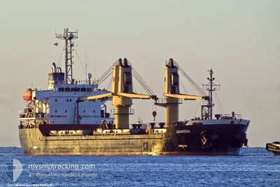
ADAVEGA
Bulk Carrier
Current Trip
| Time Travelled | 2 days |
|---|---|
| Remaining Time | --- |
| Distance Travelled | 618.70 nm |
| Remaining Distance | --- |
| AVG Speed | 11.2 Knots |
| MAX Speed | 13 Knots |
| AVG Wind | 20.5 knots |
| MAX Wind | 37.8 knots |
| MIN Temp | 10.2°C / 50.36°F |
| MAX Temp | 17.2°C / 62.96°F |
| Draught | 5.3 m |
| Position Received | 7 h, 45 m ago |
Current Position
| Longitude | 20.81333° |
|---|---|
| Latitude | 37.55182° |
| Status | Under way using engine |
| Speed | 12.5 Knots |
| Course | 140° |
| Area | Ionian Sea |
| Station | T-AIS |
| Position Received | 7 h, 45 m ago |
Info
Information
The current position of ADAVEGA is in Ionian Sea with coordinates 37.55182° / 20.81333° as reported on 2024-04-18 18:16 by AIS to our vessel tracker app. The vessel's current speed is 12.5 Knots and is heading at the port of HEREKE. The estimated time of arrival as calculated by MyShipTracking vessel tracking app is 2024-04-20 18:00 LT
The vessel ADAVEGA (IMO: 9539339, MMSI: 636019710) is a Bulk Carrier that was built in 2010 ( 14 years old ). It's sailing under the flag of [LR] Liberia.
In this page you can find informations about the vessels current position, last detected port calls, and current voyage information. If the vessels is not in coverage by AIS you will find the latest position.
The current position of ADAVEGA is detected by our AIS receivers and we are not responsible for the reliability of the data. The last position was recorded while the vessel was in Coverage by the Ais receivers of our vessel tracking app.
The current draught of ADAVEGA as reported by AIS is 5.3 meters
Weather
| Temperature | 17.1°C / 62.78°F |
|---|---|
| Wind Speed | 7 knots |
| Direction | 240° WSW |
| Pressure | 1011.4 hPa |
| Humidity | 60.7 % |
| Cloud Coverage | 1 % |
Featured Company
Last Port Calls
| Port | Arrival | Departure | Time In Port |
|---|---|---|---|
| 2024-04-12 11:03 | 2024-04-16 13:40 | 4 d | |
| 2024-04-09 17:50 | 2024-04-12 03:10 | 2 d | |
| 2024-04-03 07:56 | 2024-04-05 00:53 | 1 d | |
| 2024-03-19 11:58 | 2024-03-26 16:26 | 7 d | |
| 2024-03-10 19:10 | 2024-03-12 17:26 | 1 d | |
| 2024-03-02 17:48 | |||
| 2024-02-22 08:30 | 2024-02-23 21:37 | 1 d | |
| 2024-02-16 21:51 | 2024-02-20 15:11 | 3 d | |
| 2024-02-13 05:13 | 2024-02-14 08:27 | 1 d | |
| 2024-02-07 09:25 | 2024-02-10 05:21 | 2 d |
Last Trips
| Origin | Departure | Destination | Arrival | Distance | |
|---|---|---|---|---|---|
| 2024-04-12 05:10 | 2024-04-12 13:03 | 91.38 nm | |||
| 2024-04-05 03:53 | 2024-04-09 19:50 | 1184.66 nm | |||
| 2024-03-26 18:26 | 2024-04-03 10:56 | 523.57 nm | |||
| 2024-03-12 17:26 | 2024-03-19 13:58 | 1850.55 nm | |||
| 2024-02-23 22:37 | 2024-03-02 18:48 | 2082.12 nm | |||
| 2024-02-20 16:11 | 2024-02-22 09:30 | 329.72 nm | |||
| 2024-02-14 10:27 | 2024-02-16 22:51 | 697.34 nm | |||
| 2024-02-10 06:21 | 2024-02-13 07:13 | 695.58 nm | |||
| 2024-02-04 16:22 | 2024-02-07 10:25 | 704.54 nm | |||
| 2024-01-30 18:30 | 2024-02-03 16:25 | 704.20 nm |
Events
| Time | Event | Details | Position / Dest | Info |
|---|---|---|---|---|
| 2024-04-18 18:16 | OUT of Coverage |
37.55182 / 20.81333
Ionian Sea
TR HER
|
Speed: 12.5 kn Course: 140° |
|
| 2024-04-18 09:57 | IN Coverage |
38.94460 / 19.66452
Ionian Sea
TR HER
|
Speed: 11.9 kn Course: 152° |
|
| 2024-04-18 08:30 | OUT of Coverage |
39.20451 / 19.48539
Ionian Sea
TR HER
|
Speed: 11.7 kn Course: 151° |
|
| 2024-04-18 08:30 | Detected in Sea | Greek part of the Ionian Sea |
39.20451 / 19.48539
Ionian Sea
TR HER
|
Speed: 11.7 kn Course: 151° |
| 2024-04-18 08:30 | Status Changed | Under way using engine Default |
39.20451 / 19.48539
TR HER
|
Speed: 12 kn Course: 151° |
| 2024-04-18 08:30 | IN Coverage |
39.20451 / 19.48539
Ionian Sea
TR HER
|
Speed: 11.7 kn Course: 151° |
|
| 2024-04-18 03:52 | Status Changed | Default Under way using engine |
40.03462 / 18.92488
TR HER
|
Speed: 12.1 kn Course: 153° |
| 2024-04-18 03:50 | OUT of Coverage |
40.04228 / 18.91992
Adriatic Sea
TR HER
|
Speed: 12.1 kn Course: 153° |
|
| 2024-04-18 03:21 | Status Changed | Under way using engine Default |
40.12787 / 18.86078
TR HER
|
Speed: 11.7 kn Course: 150° |
| 2024-04-18 03:17 | Status Changed | Default Under way using engine |
40.13900 / 18.85278
TR HER
|
Speed: 11.7 kn Course: 150° |